Submitted: 30 March 2017. Accepted: 30 July 2017.
Global urban transformation caused by population shifts to urban centres has increased exposure to disasters (Killing & Boano 2016). Climate change-driven natural events have severe urban impacts (Watson 2016). Annual flooding is a common urban disaster that occurs in many Asian and Pacific countries, especially during the monsoon season. Flood events are more frequent compared to landslides, wind effects, droughts or forest fires (Marfai, Sekaranom & Ward 2015). In addition, cities are growing ahead of housing and infrastructure planning and development, which affects the capacity to cope of existing urban systems (Watson 2016).
Jakarta is the capital of Indonesia and a megapolitan city with a population of 10 million. It has been dealing with regular flood events for hundreds of years (Hellman 2015). This flooding affects vulnerable communities situated on the riverbank of the Ciliwung River, the main river that runs through the inner city of Jakarta (Hellman 2015). Communities in slum and squatter settlements dominate this area (Marfai, Sekaranom & Ward 2015). Annual flooding is generally classified as a small-to-medium-scale disaster. Such classifications are important for shaping the nature of disaster response (de Boer 1990, Gad El-Hak 2008, Glade & Alexander 2016).
Jakarta is divided into six regions: Central Jakarta, West Jakarta, East Jakarta, South Jakarta, North Jakarta and Thousand Islands. These areas are flat, coastal lowlands with an elevation of less than 10 metres above sea level (Marfai, Sekaranom & Ward 2015) resulting in regular floods that date back to the 1600s (Fiyanto 2014). The Ciliwung River is part of a dense river network susceptible to monsoonal rains and exacerbated by high tides during full moon events (Marfai, Sekaranom & Ward 2015). The worst flood in recent history was in 2007 when 454.8 square kilometres were inundated and caused 5.2 trillion rupiahs in damage (Fiyanto 2014). Eighty people were killed during the flood and around 320,000 people were evacuated (Fiyanto 2014). The urban village of Kampung Melayu in East Jakarta and its neighbourhood precincts has consistently been the area most devastated due to its exposed location.
The impact of flooding is worse for poor or urban communities. Overcrowding, marginal and unstable land, inappropriate or substandard materials and poor building construction are among the factors that increase the vulnerability of riverbank communities during monsoonal floods (Cronin & Guthrie 2013). Some solutions for sheltering people have been proposed in response to flood events but they do not adequately address the needs of the Kampung Melayu community (Marfai, Sekaranom & Ward 2015). This paper outlines results of a study examining the resilience of the Kampung Melayu community during annual flood disasters.
The community of Kampung Melayu in Jakarta Timur was selected for the study due to its location in the centre of Jakarta, and its urban context, as well as being one of the more significantly affected riverbank communities on the Ciliwung River. Flooding has become more frequent and more severe over the past decades (Fiyanto 2014).
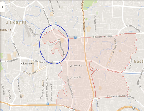
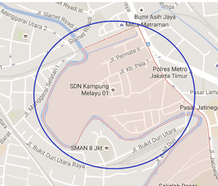
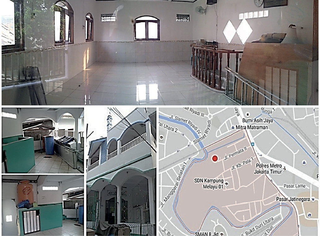
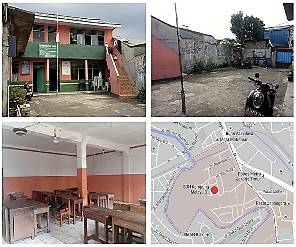
Kampung Melayu, is located in Jatinegara sub-district, East Jakarta (Figure 1). The focus area of this case study are the neighbourhoods of Kebon Pala and Tanah Rendah both are located within the Kampung Melayu precinct, less than 15 metres from the river (Figure 2).
Kampung Melayu was established in the 17th century by Malay communities from the Malay Peninsula (Chilmy & Widyawati 2013). During the Dutch colonial period in Indonesia between the 16th and 19th centuries, Kampung Melayu was a busy trading area (Chilmy & Widyawati 2013, Marfai, Sekaranom & Ward 2015). The Ciliwung River has traditionally been the busiest trading route, facilitating movement of goods and people. The location remains a principle hub for transportation in East Jakarta (Chilmy & Widyawati 2013). The main livelihood of the Kampung Melayu people is from trading, such as street vending or small business owners (Chilmy & Widyawati 2013). The current population is no longer predominantly of Malay descent. Most are migrants from other parts of Java Island including West, East and Central Java. These ‘internal migrants’ have settled in the area for at least three generations.
The most recent worst floods in Jakarta in 2007 affected 60 per cent of Jakarta; being 89 villages including Kampung Melayu. The highest flood level occurred in Kampung Melayu, reaching 3.5 metres (Fiyanto 2014). During this event, the community in Kampung Melayu evacuated to a local mosque as a temporary shelter, particularly for children and the elderly. Assistance from the local government, political parties and the Red Cross came on the second day of the flood. However, response was not very successful, mainly due to a lack of coordination among responding organisations (Marfai, Sekaranom & Ward 2015).
Learning from the 2007 flood, in 2013, the Government of Jakarta City developed and implemented a Flood Contingency Plan through Jakarta Regulation No. 1, 2012, with support from the United Nations Office for the Coordination of Humanitarian Affairs (UNOCHA) (Rakhmat 2013). The government established flood evacuation zones in 13 localities, incorporating 307 temporary shelters (Rahmat 2013). Kampung Melayu was one of the evacuation zones where the temporary shelters were made available. Public buildings, religious buildings, schools and open spaces were used to erect temporary shelters. Statistics from the Jakarta Regional Disaster Management Agency summarising the impact of the 2014 flood are shown in Table 1. Table 1 shows that Kampung Melayu ranked second for the number of people affected, second for the number of ‘internally displaced people’ (IDP) living in temporary shelters and second for the total number of IDP and temporary shelters.
Table 1: Impact of Jakarta flood of 2014.
| Area | Number of People Affected | Flood height (cm) | Number of days | Number of | |||||
|---|---|---|---|---|---|---|---|---|---|
| Sub-district | Urban Vilage | RW* | RT** | RK*** | People | IDPs | Shelters | ||
|
Jatinegara |
Bidara Cina |
13 |
99 |
4,736 |
16,563 |
20-300 |
18 |
5,995 |
21 |
|
K Melayu |
8 |
91 |
4,918 |
15,185 |
30-350 |
20 |
7,713 |
18 |
|
|
Pasar Minggu |
Pejaten Timur |
7 |
23 |
1,108 |
3,577 |
70-120 |
15 |
4,306 |
8 |
|
Tebet |
Bukit Duri |
4 |
36 |
1,358 |
7,139 |
10-200 |
18 |
7,139 |
14 |
|
Kebon baru |
6 |
41 |
2,277 |
10,546 |
10-300 |
16 |
10,546 |
7 |
|
|
Kalideres |
Tegal alur |
16 |
85 |
3,679 |
10,530 |
5-80 |
10 |
6,520 |
12 |
The monsoonal flooding events suggest that the community of Kampung Melayu has a resilience capability, developed in response to the experience of regular flooding events. According to Watson (2016,
While socio-economic factors support the resilience of communities in disaster events, this study argues that cultural and historical connections enable ‘connecting to place’ as a significant factor that helps people survive disasters and adapt to the impact. Therefore, relocating affected communities to safer locations is not always the answer and may contribute to other problems. For example, the community of Kampung Pulo accepted the resettlement program under the Normalisation of Rivers Project proposed by the Jakarta Government in cooperation with the World Bank (Hellman 2015). Under this program, the community relocated to high-rise, government-owned flats. As a result of the move, many residents lost their income and have been struggling with finances and to pay rent. The resettlement program has created insecurity in affected communities (Hellman 2015), not only socio-economically, but also in terms of culture and history. The historical and cultural values of communities in flood-prone areas have developed through, and are bound in with, everyday life. Ignoring these values in disaster response and mitigation is problematic and has negative impacts on the community (Rahmayati 2016, Sanderson 2016). However, resilience, as a community capacity does not diminish community needs for sustainable solutions in responding to and dealing with floods (Marfai, Sekaranom & Ward 2015). Enabling communities to design, procure and maintain temporary shelters and facilities that accommodate their needs without disconnecting them from their place, either permanently or temporarily, becomes critical in addressing the flood challenge.
The research method applied in this research is the case study approach. It consists of desktop research, field observation and ethnography through site visits and participatory research including interviews with community informants. It was supported by in-depth interviews with external stakeholders including urban experts, architects and planners, non-government and government representatives. The external stakeholders were chosen for their broad perspectives of the flood events and associated issues in Jakarta and to provide a comparison with the stated community experience.
In 2016, four site visits to Kebon Pala and Tanah Rendah were conducted to generate data through community consultations. Several other short follow-up visits were made to validate and verify the data with the communities and external stakeholders. The site visits were conducted in September and October 2016 and February and March 2017. The February visit was carried out during a flood event in order to observe the impact on the neighbourhoods and the people, and the combined local and government response to the disaster. It was followed by another site visit 12 days after the flood when community life had reverted to normal.
The site visits consisted of physical direct observation and informal conversations. Activities were conducted by a group of researchers with architecture, urban planning and building science backgrounds. The physical observations focused on the houses including the typology (construction, size, quality and appearance); accessibility (access to the main road and to the river); public buildings, public spaces and markets; streets and pathways and infrastructure and facilities. The observations were recorded using photographs, sketches and note-taking.
Participatory research with community members was carried out with people living closest to the river. About 45 people were involved in interviews; 60 per cent male, 40 per cent female, 70 per cent were adults and 30 per cent were elderly and children. Interview topics included individual background and personal experience. Between site visits, in-depth interviews with experts and external stakeholders were carried out to gain a broad perspective of flood problems and related issues in Jakarta. The data gathered from observation, participatory research through interviews and interviews with experts were recorded and analysed using a qualitative approach.
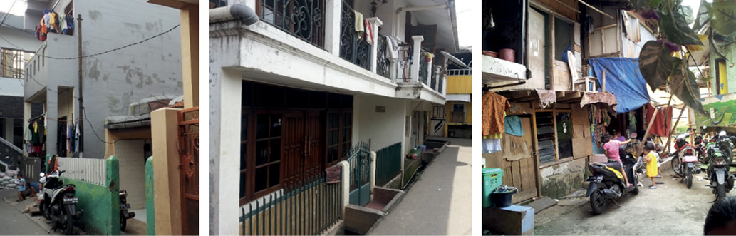
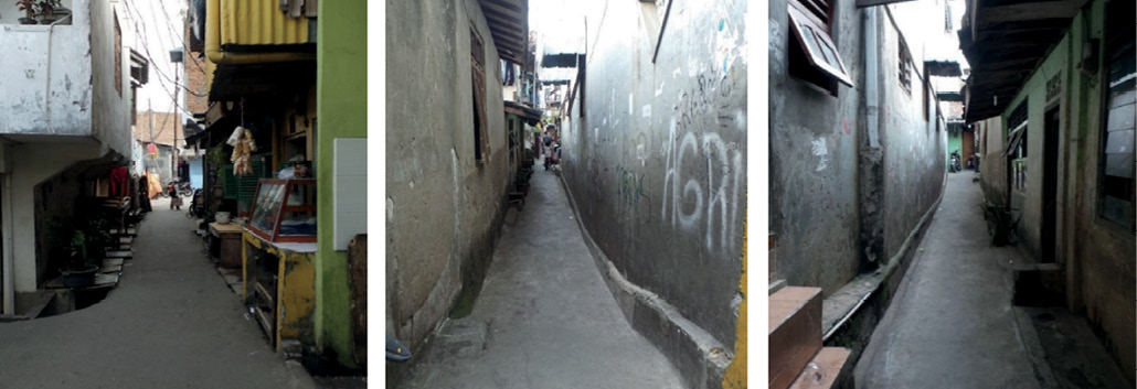
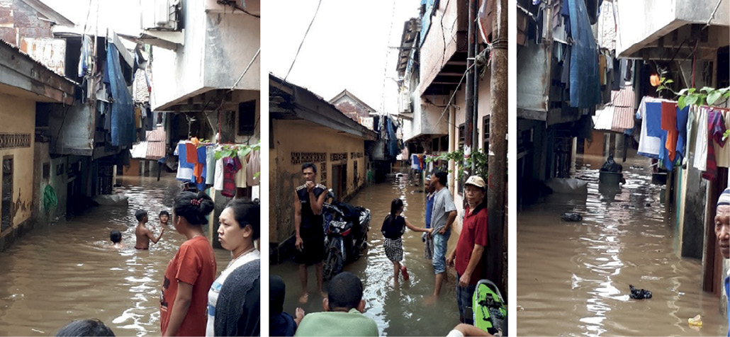
Research activity analysis revealed significant information about the lived behaviours of people in Kampung Melayu during flood events. Responses to flood events were strongly influenced by the village layout, network of streets, street widths and building form and typology. Most of the houses in the two neighbourhoods of Kampung Melayu are two-storey (Figure 3) and densely populated houses with narrow lanes (Figure 4). The location has easy points of access and is located very close to the main arterial road in East Jakarta. However, there is a range of lane widths across the settlement, resulting in different neighbourhoods having varying degrees of access. Some laneways widen to create spaces used for community interaction and small markets. Public buildings and spaces identified in the precinct included a food market, a school, some mushollas (small mosques) and a volleyball field.
In some areas, there are no open sites in a safe place on higher ground suitable for erecting temporary emergency shelters provided by government and agencies. The area has limited sanitation facilities. Not all the houses have toilets, some rely on an inadequate public toilet. In some places, a public toilet serves one residential cluster (about 50-80 people). A clean water supply relies on ground water with reticulation by electric pump. When this fails, and there are no clean drinking water facilities available, residents have to boil water before drinking or buy bottled drinking water.
The only public open site available in the flood-prone lower area is a volleyball field. There is no other appropriate open site available in safer zones on higher ground for temporary shelter. A yard of the primary school is available but has limited space to adequately accommodate the whole community.
This flood-affected area is included in the government’s urban redevelopment program that requires residents to move out from the location permanently. The community rejected the relocation plan for livelihood reasons (as they might lose their job or income from small businesses) and because of their multi-generational connection to Kampung Melayu. Residents feel connected to the place, and their historical-cultural bond has been strengthened by their shared experience during flooding. One community member (female 65) said:
Relocating to high-rise flats is qualitatively different from their current living arrangements and breaks neighbourhood structures. Broader community networks are affected as different neighbourhoods may be relocated separately. This has been experienced by the residents of nearby Kampung Pulo neighbourhood when they were resettled.
Kampung Melayu residents not only refuse to be relocated under government relocation programs, they are also reluctant to be evacuated during flood events. Another community member (female 30) said:
Many residents have lived in Kampung Melayu their entire lives and the community has built an adaptive capacity to respond to floods. For example, if flooding is less than a half metre, people move to the second floor of their houses and access other buildings via the streets (Figure 5). However, it the flood increases to three metres access and egress becomes difficult and they evacuate to safer areas in nearby neighbourhoods. They move their valuable belongings (mostly TVs, fridges, gas stoves, fans), food and groceries to the second floor and lock the house. They relocate livestock (mostly chickens) and vehicles (bikes and motor scooters) to safer areas along the road or in the vicinity of temporary shelters. The men travel between temporary shelters and their houses to ensure their property and stored belongings and valuables are safe.
During this recent flood event, one of the mushollas was used as a temporary shelter (Figure 6). However, due to space limitations, only women and children were sheltered there.
A private primary school established in the location and managed by a religious organisation was used as temporary shelter space during the flood (Fig
Flood events can last for a few days up to two weeks. People expressed their preparedness to adapt to the situation for this period of time. During post-disaster periods, community members participate in community-led recovery and clean-up activities. This usually focuses on public services and infrastructure rehabilitation, then moves to adversely affected houses. Once each neighbourhood is cleared of silt and debris, they return to normal life. Community leaders contribute significantly to leading the recovery. This behaviour, through repeated flood events, has created deep community connection and strengthened the capacity to respond to each event.
The Kampung Melayu community face many problems, including:
These problems are unproblematic, not only for those who choose to stay in their houses, but for those who are evacuated. Resilience does not mean that the community and its residents thrive under the conditions of annual flooding. The community needs solutions and interventions to help them remain as a community during flood events, with improved comfort, amenity, health and safety. The longer-term solution is to design and prototype shelter, health facilities and responses to livelihood continuity and to improve the community’s quality of life.
Community consultations to date have identified several key community preferences in the design of interventions. The preference is to have better temporary shelter with appropriate support facilities,
Based on observed patterns of lived behaviour in this study, the main challenge in designing better temporary shelters is how to find approaches that accommodate the needs of the community without disconnecting them from their place, temporarily or permanently. A solution may be to develop and implement a commun
Other important issues raised in this study:
Questions regarding the nature of shelter and facilities, especially given the lack of open space, remains. Som
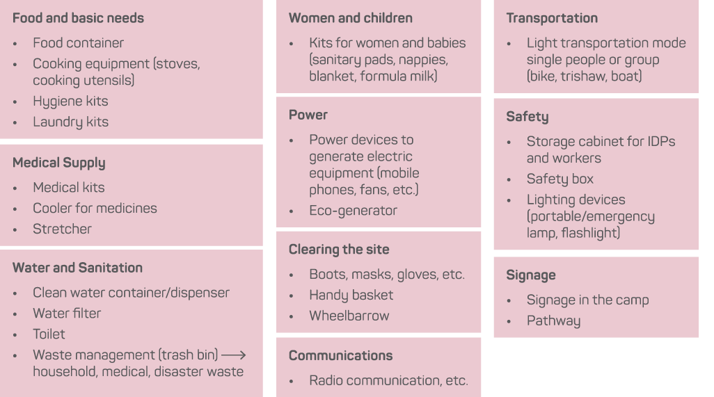
There is a long history of evidence from the Appropriate/Intermediate Technology movement dating from the 1960s of the benefits to small communities of local involvement, not just in the design of technology, but in the making and maintenance of technology (Fathy 1979, Hamdi 1991, Schumacher 1999, Willoughby 1990, Papanek 1991). Such benefits include empowering people by giving them control of the technology, strengthening local technical and organisational capacity (especially through erection, dismantling and management processes) and developing local livelihoods. Design briefs should include sustainable materials and methods and processes at an affordable cost and with appropriate durability to promote low maintenance. Alternative materials and systems may be needed if local resources are limited. Deployment methods for any new shelter systems must also be part of the design process, including storage, distribution and construction during flood events. The facilities most needed to support the design and deployment of temporary shelter systems are likely to require a degree of permanence: public kitchens, sanitation facilities, electricity generation and clean water.
Due to space limitations in the case study location, any outdoor communal temporary shelter is problematic and a low priority for targeting of resources. Therefore, the designs should be focus on the improvement of the current locations and buildings used as temporary shelters, such as the local musholla and school. The improvements should be on the additional facilities needed and the alternative solutions possible to make people comfortable and less stressed during evacuation periods. There is also an urgency to identify vulnerable groups in the design process including women, children and the elderly and to design specific services and shelter types to meet their needs. Alternative designs include portable shelters for single family use, using balconies and other external spaces. Based on the inputs from the community and external experts, some options for facilities are proposed in Figure 8, as complementary to temporary shelters.
The next stage of the project will commence in late 2017, with a series of community-led design workshops on site with community representatives as well as staff, researchers and students from Binus University, Indonesia and Swinburne University of Technology, Australia. Other stakeholders such as non-government and government representatives will be invited.
In this study, the identified, lived behaviours of the residents of Kampung Melayu community and its neighbourhood precincts in responding to annual flood events demonstrates a high degree of community resilience. Such behaviours shows that cultural and historical connection to place is a significant driver of their desire to remain in their flood-affected riverbank location on the Ciliwung River. This paper outlined a community-led design approach to create innovative and appropriate temporary shelter and technical interventions to support community preferences to permanently remain in place. The approach combines community participation as well as advice and input from experts to enable flood-affected communities to produce satisfactory designs in accordance with their immediate and future needs. Further, it is possible that the outcomes of this design approach are applicable to any urban flood events in modern urban villages, not only in developing countries but also in developed cities in the Asia-Pacific region.
Chilmy V & Widyawati K 2013, Perkembangan Pola Permukiman Masyarakat Kampung Melayu, Faktor Exacta, vol. 6, no. 2, pp. 87-98.
Cronin V & Guthrie P 2013, Community-led resettlement: From a flood-affected slum to a new society in Pune, India, Beyond Shelter after Disaster: Practice, Process and Possibilities, Routledge, London and New York, pp. 58-74.
de Boer J 1990, Definition and Classification of Disasters: Introduction of a Disaster Severity Scale, Journal of Emergency Medicine, vol. 8, pp. 591-595.
de Boer J 2016, Risk, resilience and the fragile city, Urban disaster resilience, New dimensions from international practice in the built environment, Routledge, New York and London, pp. 76-86.
Fathy H 1979, Architecture for the Poor: An Experiment in Rural Egypt. (Paperback ed.) Chicago: University of Chicago Press.
Fiyanto A 2014, Memahami Banjir Jakarta, Greenpeace Indonesia. At: http://m.greenpeace.org/seasia/id/high/blog/memahami-banjir-jakarta/blog/47986/.
Gad El-Hak M (ed) 2008, Large-Scale Disasters: Prediction, Control and Mitigation, 1st Edition. Cambridge: Cambridge University Press.
Glade T & Alexander DE 2016, Classification of Natural Disasters, in Bobrowsky PT ed, Encyclopedia of Natural Hazards. Dordrecht: Springer Netherlands.
Hamdi N 1991, Housing Without Houses: Participation, Flexibility, Enablement, London: Intermediate Technology Publications.
Hellman J 2015, Living with floods and coping with vulnerability, Disaster Prevention and Management, vol. 24, issue. 4, pp. 468-483.
International Federation of Red Cross and Red Crescent Societies 2014, IFRC Framework for Community Resilience, Geneva: International Federation of Red Cross and Red Crescent Societies.
Killing A & Boano C 2016, Reconstructing the city, The potential gains of using urban planning and design practices in recovery and why they are so difficult to achieve, Urban disaster resilience, New dimensions from international practice in the built environment, Routledge, New York and London, pp. 35-53.
Marfai MA, Sekaranom AB & Ward P 2015, Community response and adaptation strategies toward flood hazard in Jakarta, Indonesia, Natural Hazard, vol. 75, pp. 1127-1144.
Papanek VJ 1991, Design for the real world: human ecology and social change (2nd ed.). London: Thames & Hudson.
Rahmayati Y 2016, Post-disaster housing: Translating socio-cultural findings into usable design technical inputs, International Journal of Disaster Risk Reduction, issue. 17, pp. 173-184.
Rakhmat B 2013, Contingency plan program DKI Jakarta Province, UNOCHA. At: www.docs.unocha.org/sites/dms/ROAP/Indonesia/Documents/Jakarta%20Contingency%20Plan.pdf.
Rekapitulasi Kejadian Banjir Bulan Januari 2014, Badan Penanggulangan Bencana Daerah (BPBD-DKI Jakarta Province). At: http://bpbd.jakarta.go.id/assets/attachment/document/REKAPITULASI_KEJADIAN__BANJIR_Dari_Bulan_Januari_sd_Agustus__TAHUN__2014.pdf.
Sanderson D 2016, Urban disaster resilience, New dimensions from international practice in the built environment, Routledge, New York and London, pp. 3-15.
Schumacher EF 1999, Small Is Beautiful: Economics As If People Mattered: 25 Years Later...With Commentaries (2nd ed.). Berkeley: Hartley & Marks.
Wates N (ed) 1999, The Community Planning Handbook: How people can shape their cities, towns and villages in any part of the world. London: Earthscan.
Watson GB 2016, Designing resilient cities and neighbourhood, Urban disaster resilience, New dimensions from international practice in the built environment, Routledge, New York and London, pp. 21-34.
Willoughby KW 1990, Technology Choice: A Critique of the Appropriate Technology Movement. London: Intermediate Technology Publications.
Dr Yenny Rahmayati is a Postdoctoral Research Fellow at Centre for Design Innovation, Swinburne University of Technology under the Humanitarian Habitat and Design Project.
Dr Matthew Parnell is a senior lecturer in Design Management and Strategy at Swinburne University of Technology. He is a researcher, educator, author and sustainability practitioner in the built environment, education, research, business and social enterprise.
Vivien Himmayani teaches in applied technology at the Binus University in Indonesia. Her research includes socio-cultural and community resilience in Jakarta to understand community resilience of low-income communities.

