For the purposes of this article, the term ‘landslide’ is used in a very broad sense to include slope failures and cave-ins involving human activity, mine subsidence and cave-ins in paved roads. It also includes the flash flood runout in the distal part of debris flows (distal meaning remote from the point of attachment or origin), slow movements of a few centimetres a year, as well as the well-recognised rock falls, debris slides and other gravity-driven downward movements of material commonly thought of as landslides.
In Australia, 114 landslides are known to have caused injury or death during the period 1842 to December 2011. At least 138 people have been killed and 174 injured. The naturally-occurring events causing death varied from the fall of a single rock to spectacular debris flows and their flash flood runouts. Many landslides that killed or injured people were the result of human activity. During the period 2000-2011, over half the landslides causing injury or death were directly or indirectly human-caused. Most deaths were caused by trench and beach sand or excavation cave-ins, while most injuries were caused by edge-of-road collapses due to vehicle weight.
Around 370 buildings were damaged or destroyed by 83 landslides and mine subsidence events including superficial damage from debris flows and the subsequent runout entering buildings. The estimated cost of landslide, debris flow runout and mine subsidence damage to buildings, residential land, fences, retaining walls, swimming pools and the like during the period 1842-2011 is approximately $82 million in 2010 dollars. Landslides also caused considerable damage and disruption when they impacted or destroyed roads (around 300 landslides during the period 2000-2011), railways and bridges. Unfortunately the readily available data are too few to estimate a monetary cost.
Of the 114 landslide events causing injury or death to December 2011, 36 were rock falls or topples, including rocks displaced by climbers—some involving a single rock. Nineteen landslides involved material falling from cliffs.
The two most lethal landslides were both debris flows.
The Briseis Dam Disaster, Derby, northeast Tasmania happened on 4 April 1929 and killed 14 people. Rainfall of 450mm during the previous two days, followed by 125mm in the catchment in 1.5 hours, caused the rock-filled concrete Briseis Dam on the Cascade River to burst, releasing a wall of water six metres high. The water raced down the river gully, sweeping away a house and killing the family of five, as well as a five-year-old girl. It then cut a channel 30 metres deep and 64 metres wide through a low hill in its path. It demolished stables in its path, killing three people and 12 horses. The torrent was 180 metres wide and tree logs were deposited over 21 metres above normal river level. The width was evident from the gouged-out channel left behind, and the main road was obliterated. By cutting through the low hill, the river’s course was permanently changed to follow the channel gouged out by the torrent. The wave of water at Derby was four metres high, however a rocky outcrop on its outskirts saved the town. The flood was diverted, striking a mining tailings hill about 60 metres high and carrying away half the hill, leaving a sand cliff. Three people lost their lives and several houses were swept away, including the Briseis Company’s powerhouse and offices. Two bridges on the Ringarooma River, one on each side of Derby, were destroyed and the Briseis tin mine was flooded. It did not resume operations for five years after the event. Many people were homeless, two cars were lost, the furniture in flooded houses was damaged, and the recreation ground outbuildings demolished. A total of six houses were destroyed at Derby, and fences were destroyed and houses flooded at nearby Branxholm. Fourteen people were killed in the 4.8km between the Briseis Dam and Derby. The torrent had carried thousands of tonnes of trees, rocks, gravel and boulders. A 10-tonne granite boulder was moved 3km.
The Thredbo, NSW landslide of 30 July 1997 injured one person and killed 18, as well as destroying two ski lodges and several vehicles. According to the Coroner’s report (Hand, 2000), the landslide happened on the slope below the Alpine Way—the highway linking Jindabyne, NSW on the eastern side of the Snowy Mountains with the Murray Valley Highway on the west in Victoria. Perched above the ski resort village of Thredbo, the road was originally built as a short-term construction road and was not intended to be a highway. It rested on uncompacted fill and creep (very slow land movement) in the fill had been occurring for years before the catastrophic slope failure. The creep caused joints in a water main to leak for at least two months, and possibly as long as 12 months, before the landslide. As the separation at the joints worsened, the leakage increased. A portion of the uncompacted fill embankment became saturated with water, triggering the landslide at 11.30pm. The first stage of the failure was between the top ski lodge, Carinya, and the Alpine Way. Carinya Lodge was hit by collapsing soil, toppling it forward. The ski lodge was then impacted by a mudflow that carried it downslope and onto Bimbadeen Lodge. The only occupant of Carinya Lodge was killed and 17 others perished in the wreck of Bimbadeen. The sole surviver was rescued after almost three days in the rubble of Bimbadeen Lodge.
During the period January 2000 to December 2011, 24 people died and 100 were injured in Australia as a result of 46 landslides—an average of two deaths per year.
The most lethal incident happened on the Old Pacific Highway, Somersby, NSW, on 8 June 2007. A low pressure weather system swept across the east coast of NSW dumping more than 200mm of rain over four days, causing flood conditions. A section of the Old Pacific Highway collapsed due to undermining by a flooded creek because of corrosion of the steel pipes of a culvert. A car on the road at the time of the cave-in drove into the hole, killing its five occupants; two adults and three children. Investigations showed that the pipes had been corroding for almost 25 years and sinking of the road was noticed some seven years before the cave-in. The resultant dip in the road had been asphalted over in 2002 and again in 2004.
The largest number of injuries in a single event was due to a landslide on the Cairns-Kuranda scenic railway on 26 March 2010. Heavy rain triggered a debris slide from the slope above the railway line just before the first tunnel. The landslide blocked the line and the first of the two locomotives pulling the train ran into it and was derailed. Luckily, the second locomotive was able to push the train back to Redlynch where five injured passengers were taken to hospital by ambulance. The remaining passengers disembarked at Freshwater and one passenger requiring a wheelchair was taken to hospital. In addition to the injuries, the closure of the railway line adversely affected tourism and business in Kuranda.
During the period 2000-2011, 14 rock falls or topples, some from natural causes and others from human activity, killed or injured people.
In the Wollangambe Canyon, Wollangambe National Park in the Blue Mountains of NSW, six people were reported missing when they failed to return from a day canyoning trip on 12 January 2010. They were well-equipped except they did not have an emergency beacon. About 50 people searched for two days and located them on January 14. One of them, a boy aged 15, had been killed only a few hours earlier, apparently in a rock fall when a sandstone ledge had collapsed. The five survivors were airlifted to Richmond Royal Australian Air Force base by police helicopter and taken to hospital to be treated for dehydration, hypothermia and minor injuries. They were discharged the following day. The boy’s body had been trapped under the fallen rocks and rain had hindered the search and rescue operation. His body was recovered on 15 January.
At about 4.00am on 20 June 2005, rocks with a total volume of about one cubic metre, rolled from the Lake George escarpment, NSW, onto the northbound lanes of the Federal Highway, causing a multi-vehicle accident. Two people were injured. A car collided with a boulder and was undriveable. A semi-trailer jack-knifed after hitting a boulder and ended up in a southbound lane, partly jutting out over Lake George, and a station wagon overturned, caught fire, and was destroyed. The truck driver, though injured, and another person, rescued the injured driver from the car before it was engulfed in the flames.
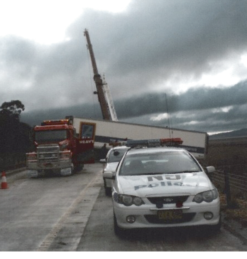
Image: Dr Marion Leiba
A semi-trailer jack-knifed after being hit by rocks falling from the Lake George escarpment.
On 4 November 2001 at Jan Juc in south west Victoria, an 18-year-old man was walking with friends along the beach at the time of a large rock fall from an 80 metre cliff. He was buried up to his shoulders in the landslide. His two companions managed to jump clear. It took three hours to rescue him because of dangerous conditions caused by continuing rock falls. He was flown to hospital with crush injuries to both legs.
On 30 January 2000 a man fell while climbing at Ginninderra Falls, NSW, 18km northwest of Canberra. His rope broke and he dislodged some rocks during the fall causing a human-induced rock fall. The rocks fell on him causing a suspected broken leg, ankle and wrist. After being winched to safety, he was transported to hospital by rescue helicopter.
For over half the landslides, deaths and injuries were either directly or indirectly caused by human activity. A total of 30 landslides killed 13 people and injured 60 as summarised on Table 1.
Table 1. Landslide deaths and injuries caused by human activity during the period January 2000 – December 2011.
Landslide type |
No. of landslides |
No. of deaths |
No. of injured people |
|---|---|---|---|
Trench cave-ins |
9 |
2 |
8 |
Beach sand cave-ins |
9 |
3 |
7 |
Other excavation landslides |
4 |
1 |
3 |
Edge of road collapse from vehicle weight |
3 |
5 |
38 |
Other human involvement landslides |
5 |
2 |
4 |
Total for human involvement landslides |
30 landslides |
13 people killed |
60 people injured |
Of the 30 landslides, nine were trench cave-ins. On 14 May 2009, three men were working at Furber Street, East Maitland, NSW, in a 3-4 metre deep, 25 metre long soil trench at a horse trainer’s property while making a plunge pool for the horses. The men were setting formwork for plastering the sides of the trench when the side(s) caved in and loose dirt heaped on the surface fell into the trench. One man was able to escape and go for help. The second, aged 43, was buried from the waist down and suffered a cut on his head and crush injuries. He was flown to Newcastle hospital by rescue helicopter. The third, aged 28, was completely buried and died at the scene. His body was recovered over nine hours later. The street was blocked off for several hours to assist the rescue and investigations.
Another nine landslides were cave-ins caused by young people digging deep holes in sand at the beach. At 1770 beach, near Agnes Water, Queensland, on 15 August 2006, three boys, Dutch tourists, aged 11, 13 and 15, were digging holes in the beach when the sand caved in. Two of the boys were kneeling in the hole and were buried up to their chests. The 11-year-old managed to scramble free. The 13-year-old was trapped for more than an hour and was given oxygen while being rescued. He was subsequently treated by paramedics at the Surf Club. The 15-year-old died at the scene. Police, Fire, Ambulance and SES officers were all involved in the rescue.
Around one fifth of the deaths and over one third of the injuries caused by landslides during the period 2000-2011 happened in just three edge-of-road collapses under the weight of vehicles. The worst happened on Dove Lake Road, just past the Visitors Centre in Cradle Mountain National Park, Tasmania, on 18 February 2001. A bus had edged to the side of the road to make way for an oncoming vehicle. The soft shoulder of the road gave way under the weight of the stationary bus causing it to plunge down a ravine. Four people were killed and 14 were injured.
Over the same timeframe, 83 landslides, mine subsidence and tunnel collapse events damaged or destroyed about 370 buildings or their interiors. The most expensive case of building damage from non-debris flow landslides was at Lawrence Vale, Launceston, Tasmania in the 1960s. Two adjacent, relatively slow-moving landslides in Tertiary sediments destroyed 35 houses and the land was also written off. The cost in 2010 dollars is estimated to be $13.4 million.
The Briseis Dam disaster in northeast Tasmania, destroyed at least 10 buildings and it is estimated that it may have damaged about 45 buildings or their contents. The estimated cost in 2010 dollars is about $1.5 million.
The estimated cost of landslide, debris flow runout and mine subsidence damage to buildings, residential land, fences, retaining walls, swimming pools, etc. during the period 1842-2011 is approximately $82 million in 2010 dollars.
During the period January 2000 to December 2011, approximately 70 buildings were affected by 26 landslides, including mine subsidence. The results varied from damage to contents to the total destruction of the building.
The estimated cost of landslide and debris flow runout damage to buildings, residential land, fences, retaining walls, swimming pools, etc. during 2000-2011 is approximately $2.7 million.
The types of slope instability events causing building damage are shown in Table 2.
Table 2. Slope instability events affecting buildings during the period January 2000 – December 2011. These statistics exclude buildings damaged or destroyed during the flash floods and debris flows in the Lockyer Valley, Queensland on 10 January 2011.
Type of slope instability event |
Number of events affecting buildings |
Estimated number of buildings affected |
|---|---|---|
Debris flows |
11 |
24 |
Debris slides |
4 |
4 |
Excavation related |
4 |
5 |
Tunnel/mine subsidence |
3 |
30 |
Slow moving landslides |
2 |
4 |
Earth slump |
1 |
1 |
Rock fall |
1 |
1 |
Debris flows were a common cause of building impact. Almost half (11 out of 27) of the landslides affecting buildings were debris flows. For example, on 3 April 2000 at Castle Hill, Townsville, Queensland, four debris flows, three east facing and one northeast facing each with a volume of about 500 cubic metres weathered granite, were triggered by torrential rain from Cyclone Tessi. Almost 140 houses were initially evacuated and several were damaged by the runout. Several houses had a considerable volume of debris in their lower storey while others suffered water and mud spoilage.
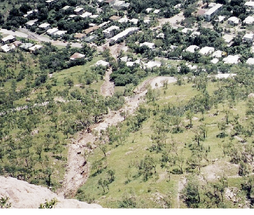
Image: Dr Marion Leiba
Large debris flows at Castle Hill were triggered by Cyclone Tessi.
Around 30 June 2005, at Lansell Avenue, Currumbin, Queensland, a landslide (probably a debris flow) severely damaged and put at risk at least six properties. Decks of at least two houses, and a spa, were washed down the hillside during a deluge and at least one retaining wall was damaged. Residents were advised to evacuate.
On 22 March 2010, intense rain brought by a severe storm triggered a debris flow from the escarpment at Kings Park, Perth, Western Australia, behind the Adelphi, Waldorf, Acacia and Park Lane apartments, causing more than 100 residents to be evacuated. Mud surrounded two vehicles and entered apartments through the windows, filling two with mud deeper than 1.2 metres. A section of the eastbound lane of Mounts Road was also closed.
On 19 March 2004, in Cairns, Queensland, heavy rain associated with a tropical low (later Tropical Cyclone Grace) triggered a fill failure in a disused road uphill from Hillview Street, Whitfield. This pushed trees and topsoil into the downstairs rooms and garage of a house. Luckily the owners were overseas. Two cars in the garage were pushed forward, one into a column which dented the rear of the vehicle. Branches punched holes through the rear wall of the house in two places and through windows. The landslide volume was approximately 1500 cubic metres. Slope instability related to nearby excavations affected five buildings.
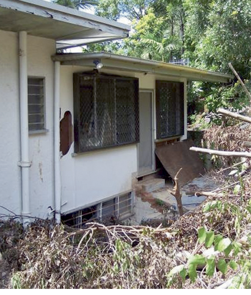
Image: Dr Marion Leiba
Fill failure in a disused road inundates a house in Cairns.
An expensive example was the destruction of the Indian Chilli Restaurant in Crown Street, Surrey Hills, Sydney, on 27 November 2007. Excavation for construction over six months before may have been partly responsible. The restaurant’s foundations were exposed to the weather for the first time in the life of the old, fragile building. The evening before the 27 November there was heavy rain. Noises were first heard during the evening of the 27, and by the next day there was cracking, partial disintegration, and the building was leaning towards the excavation. The old building was subsequently demolished and neighbouring buildings evacuated as well as the road temporarily closed. The contents of the restaurant, valued at more than $200,000, were lost.
A spectacular, though less costly landslide happened on 27 November 2001 on the east side of Northbourne Avenue, Canberra, ACT, in the block north of Cooyong Street. Almost half of the western wall of an eight-metre-deep excavation failed, causing two prefabricated site buildings to tilt at angles of about 15-30 degrees. The headscarp consisted of two steps, each one metre high, coinciding with the inner edge of a concrete footpath. One lane of Northbourne Avenue was closed until 3 December.
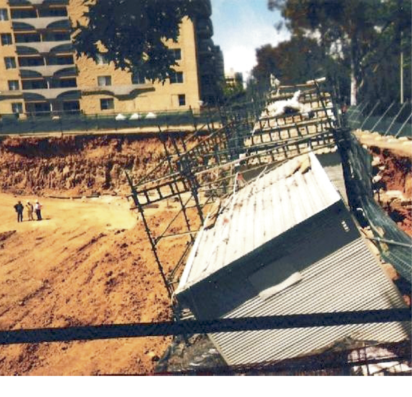
Image: Dr Marion Leiba
A landslide at a building site in Canberra causes two prefabricated site buildings to come off their foundations.
Two slow-moving landslides that damaged or destroyed buildings were both in Buderim, Queensland in 2010. The most destructive was in Durham Crescent on 19 December. Prolonged high rainfall triggered a slow-moving landslide that caused one house and the garage of an adjacent house to move downhill. One house moved two metres in a week and was deemed unlivable. The adjacent house was unaffected as at 4 January 2011 but the garage was warped from the movement. The downhill part of the road suffered large cracks in the tarmac and was cordoned off. The occupant of the house below Durham Crescent voluntarily self-evacuated as a precaution.
Mine subsidence and tunnel failure have damaged or destroyed an estimated 30 buildings during the period 2000-2011. The estimated cost in 2010 dollars is about $6.5 million.
The worst case was at Collingwood Park, Ipswich, on 26 April 2008. Part of the suburb is 130 metres above the disused Westfalen coal mine. Subsidence had previously occurred in 1988 and 1992. The 2008 episode happened in the early morning of 26 April and had stabilised over the whole affected area by the end of 2 May. It damaged around 20 houses in Duncan, Fowler, Moloney, McInnerney and McLaughlin Streets and Warren Court. Seven of the most seriously damaged houses were evacuated. Structural engineers were engaged to assess houses in the subsidence area. The State Government budgeted $10 million to fund present and future repairs caused by the subsidence and to buy houses at pre-subsidence market value if the damage was too great.
In the Sapphire and Rubyvale area gemfields, Queensland, some time during the period 17-19 January 2008, severe flooding caused shallow sapphire mines to cave in, swallowing caravans and sheds, and destroying some homes and livelihoods.
On 2 November 2005, a tunnel failure occurred at the entrance to the Pacific Highway, Lane Cove, NSW. All residents of a three-storey brick block of flats on Longueville Road were evacuated at about 2.30am when a 10-metre-deep hole appeared in front of and under a corner of the building. A water main broke and sections of the building fell into the hole, which was caused by failure of shale in a section of the Lane Cove Tunnel, then under construction. The failed section was the site of an exit ramp that intersected with a ventilation shaft. Over 1000 cubic metres of concrete was pumped into the hole to try to stabilise the area. The city-bound lanes of Epping Road were closed to traffic for two days.
Hundreds of landslides have damaged or disrupted roads, railways, bridges, culverts, paths and drains. There are inadequate data to estimate the financial cost, but it would total many millions of dollars.
The record in the Geoscience Australia Australian landslide database for landslides impacting or damaging roads during the period 2000-2011 is almost certainly incomplete. In a number of entries, particularly those relating to the Cairns area, a series of landslides on a single road are recorded as a single entry. A cursory examination of database entries suggests that well over 300 landslides adversely affected roads during the period. This excludes holes appearing in roads usually due to water beneath the tarmac, or because of mine subsidence.
The effect of landslides can vary from one lane being closed for a few hours because of a failure in the cut on the uphill side of the road, with debris falling on the road, to structural damage to the road necessitating repairs and sometimes closing some or all of the road for days or even longer.
On 4 February 2011, intense, short-period rainfall and an overflowing drain beside the Princes Freeway (Morwell Bypass) in Victoria caused a landslide in the adjacent, un-used north wall of an open cut coal mine. Cracks 2-3cm wide and 2cm deep appeared in both sides of the freeway and the section was closed for three months. Traffic was redirected through Morwell.
Landslides that block an entire road can affect business and tourism. For example, landslides continue to occur near ‘Pooh Bear Corner’ on the Kings Highway, which is the shortest route between Canberra and the South Coast of NSW. This is a popular route for Canberra holiday makers who support coastal communities with tourist dollars.
Another example is the closure of the Cunningham Highway at Cunningham’s Gap in south Queensland. On 5 December 2010, a landslide from the steep mountainside occurred above the road. The Council and the Warwick Chamber of Commerce were concerned about the economic impact of the closure on tourism, including motels, service stations, and fast food outlets.
An expensive case of isolation was the result of landslides triggered by 370mm of rain in a 24-hour period during 22-23 March 2011 at Wilsons Promontory, Victoria. The Wilsons Promontory Road to Tidal River was closed by at least one landslide and a bridge collapse involving a debris fall due to flash flooding. A massive landslide also closed the Mount Oberon access road. At least 200 campers were evacuated by helicopter and 400 were stranded in the National Park. The closure of the park also adversely affected tourist operators.
A very small landslide with serious consequences happened on Greenhill Road, near Greenhill, South Australia, on 22 June 2000. A man was seriously injured when his car was hit by a large boulder. It hit the rear driver’s side of the sedan then bounced onto the other side of the road. Rescue crews cut the roof off the car to free the man who was taken to hospital. Two members of the rescue crew were sprayed with hydraulic fluid while using cutting tools and were also taken to hospital.
A landslide on Springbrook Road, Springbrook, Queensland, on 5 April 2009 had a luckier outcome. Heavy weekend rainfall had triggered a debris slide in the cut in the uphill side of the road. As a station wagon drove past, the slope moved and the vehicle ended up being sandwiched between two large boulders. The larger, with a volume of about 0.5 cubic metres, crushed the bonnet of the car. The smaller, with a volume of about 0.3 cubic metres, came to rest at the rear corner of the vehicle. Rocks also hit and broke through the metal of a back door. Fortunately none of the four occupants was hurt. The road was closed for several weeks.
There have been 15 instances of holes, excluding ordinary potholes or mine subsidence, appearing in paved roads in populated areas. Six of these were identified as being cave-ins caused by broken or leaking water mains under the road. All bar one or two were attributed to water under the road tarmac from flooding or other causes. The amount of disruption caused by these holes depended on their size and location, but one had very expensive consequences.
On 25 March 2009, a five-metre-deep hole appeared in the bitumen at the intersection of Brisbane and East Streets, Ipswich, Queensland at about 9.15am. A leaking water main had eroded soil under Ipswich’s busiest traffic intersection. The hole subsequently grew to be five metres long with an estimated volume of about 50 cubic metres. Traffic was thrown into chaos and, at about 6.30pm, police drew an exclusion zone around surrounding streets and a 300 metre air exclusion zone. The intersection re-opened at 5.00pm the next day. It took 30 hours to repair the hole by pumping in a special concrete mix, at a cost of $750,000. Business losses were expected to take the total cost to more than $1 million.
The tragic events of 10 January 2011 are described separately because it is difficult to differentiate how much of the damage and fatalities were caused by debris flows and their runout and how much was due to the fast-moving floodwaters that did not originate as debris flows. A debris flow near its source is laden with debris and flows as a torrent because of its high water content (up to 50 per cent), but it becomes a flash flood at its farthest end after much of its solid material has been deposited.
The events in Toowoomba and the Lockyer Valley were caused by prolonged high rainfall followed by a super storm which dumped 80mm of rain in just 30 minutes. A rain gauge at Withcott recorded 150mm in 50 minutes. This deluge falling on the Toowoomba Range triggered severe flash flooding in Toowoomba, and debris flows and flash floods in the Lockyer Valley area, which killed 23 people with an unstated number injured, and destroyed numerous houses and other buildings, vehicles, and farm machinery. There was considerable infrastructure damage, including roads, footpaths, bridges, and railway lines.
A two metre wall of water, described as a “torrent, out of nowhere”, hit the Toowoomba CBD at about 1.00pm after the West and East creeks broke their banks. The flash flood piled up cars, flooded houses and businesses and resulted in two deaths. It is unlikely that this originated as a debris flow. However, the railway station at Spring Bluff was destroyed by what appears to have been a debris flow from the steep hill slope above the railway.
A “mud torrent came hurtling down the mountain” (a debris flow) on to Murphys Creek where it destroyed houses, killed people and deposited two metres of mud.
The flash flood arrived in Grantham at about 3.30pm. It appeared as a wave of water across the paddocks, washing away people in their houses and cars. Some of this water would have originated as debris flows from the hill slopes.
The following information is quoted from Risk Frontiers (2011).
“23 people died in the flash flood events in Toowoomba and the Lockyer Valley: 14 in Grantham, 2 in Murphy’s Creek, 2 in Spring Bluff, 2 in Postman’s Ridge, 1 in Helidon and 2 in Toowoomba.
Houses built adjacent to waterways were washed away in the Murphy’s Creek township, Postman’s Ridge, Grantham and other locations due to high water velocities (up to 3 to 4 m/s) and high water depths. 29 houses were completely destroyed in Grantham, with 130 severely damaged. Nearly every house in the ‘southern development’ area of Grantham sustained structural damage caused by the velocity of the floodwaters. Some were washed off their stumps and completely destroyed, whilst others were rendered uninhabitable.”
It is highly likely that the four people killed in the Murphys Creek-Spring Bluff area died as a result of debris flows and their runout. No figures were given for the number of houses damaged or destroyed there but, based on the figures given for Grantham, an estimated 45 houses may have been affected by debris flows. It is possible that debris flows may have caused damage and fatalities in other parts of the Lockyer Valley and that their runout contributed to the tragedy at Grantham.
Although landslides are not well-recognised by the general public as being a problem in Australia, they have killed at least 138 people which is more than nine times the number killed by earthquakes. Deaths from landslides have not decreased in recent times. During the period 2000-2011, 24 people died in landslides and 13 of those were killed by human-caused landslides. The worst culprits were excavation failures, including trench collapses and children digging in sand. Six people died in landslides caused by excavation during the period 2000-2011. Education about the risk of working in trenches and other excavations and of digging in sand may save lives.
Landslides and mine or tunnel subsidence also continue to damage buildings or their contents with around 70 being affected during the period 2000-2011. Of these, an estimated 30 were affected by mine subsidence and 24 by debris flows.
Landslides also continue to damage roads, railways, culverts and bridges. For example, during the period 2000-2011, well over 300 landslides adversely affected roads. There are insufficient data to estimate the cost to infrastructure, but it could be in the millions of dollars.
As in other parts of the world, debris flows in Australia have been lethal and destructive. The two most lethal landslides in Australia’s recorded history are the 1997 Thredbo landslide, killing 18 people, and the 1929 Briseis Dam disaster, killing 14 people. Both were debris flows. Debris flows grade into flash floods as the water content increases. The destructive nature of flash floods was highlighted by the Toowoomba and Lockyer Valley disaster in 2011 in which 23 people were killed and an estimated 200 houses damaged or destroyed in flash floods and debris flows.
Geoscience Australia for supporting this research. Adele Bear-Crozier, Libby Metz and Jane Sexton for critically reviewing the manuscript and suggesting improvements.
Geoscience Australia, 2012, Australian Landslide Database, www.ga.gov.au.
Hand, D., 2000, Report of the inquest into the deaths arising from the Thredbo landslide. NSW State Coroner’s report.
Michael-Leiba, M., 1999, Impact of landslides in Australia to June 1999, Australian Journal of Emergency Management, Vol. 14, No. 3, pp. 30-31.
Risk Frontiers, 2011, State-wide natural hazard risk assessment. Report 8: Major historical flash flooding in Queensland, Report for Queensland Department of Community Safety, July 2011.
Dr Marion Leiba worked as a volcanologist, earthquake seismologist and landslide scientist. She worked with Geoscience Australia for 20 years until her retirement in November 2001. She consults as a Disaster Risk Scientist and updates the Australian Landslide Database for Geoscience Australia. Marion was born in Australia and has a PhD from University of Hawaii.

