By Duncan McLuckie, Chair, National Flood Risk Advisory Group
The recent devastating impacts of floods in different areas of Australia highlights the risks faced by communities when they interact with floods. It provides a demonstration that the occupation of floodplains, whether due to the legacy of former decisions or as a result of future decisions, comes with an inherent flood risk that needs to be managed.
Managing this risk and thereby improving community resilience to flooding needs to consider how to limit the interaction between communities and flooding. Fundamental to this is an understanding of the range of potential flood behaviours so that this can inform decision making.
To support this understanding, the National Flood Risk Advisory Group (NFRAG)1 worked with the Australian Institute for Disaster Resilience (AIDR) and a range of industry professionals to update and expand the handbook collection, with financial assistance from the National Emergency Management Program. The collection now includes:
In addition, background documents were produced as part of development of this series, including:
This collection is available at www.knowledge.aidr.org.au/handbook-7-managing-the-floodplain.
The collection supports improved management of flood risk in Australia by promoting the consideration and, where necessary, management of flood impacts on existing and future development within the community.
It aims to improve community flood resilience using a broad risk management hierarchy of avoidance, minimisation and mitigation to reduce the health, social and financial costs of occupying the floodplain, increase the sustainable benefits of using the floodplain and improve or maintain flood-dependent ecosystems.
Handbook 7 outlines the flood risk management framework that can provide a sound basis for understanding how flood behaviour may vary across the floodplain and between events of different sizes, and assessing and deciding on management options to address flood risk. There are a wide range of management options which may be suitable depending upon the location. These may involve flood warning, flood mitigation, emergency management and land-use planning.
New Guideline 7-5 focuses on managing flood risk related to new development. Such development within the floodplain can expose land uses and their users to a significant risk of flooding, can impact on flood behaviour and can affect the flood vulnerability of existing developments and their users.
Therefore, managing the growth of risk due to increasing development density within the floodplain relies on an understanding of the range, extent and frequency of flood behaviour. In particular, it involves considering the full range of flood behaviour in identifying:
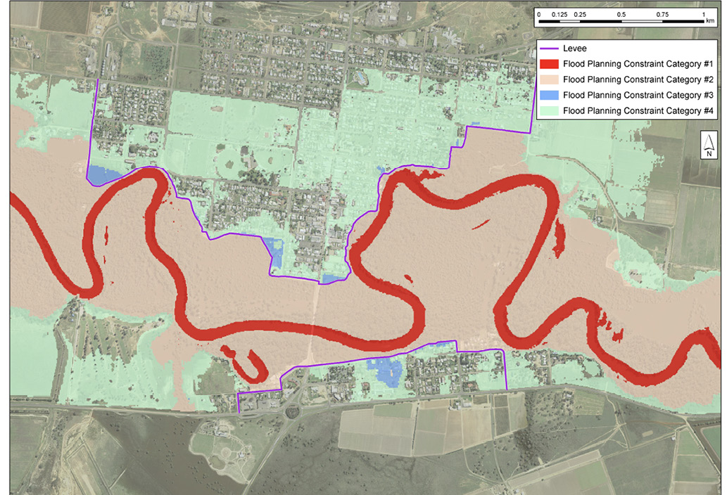
Guideline 7-5 provides advice on how flood risk managers can expect this often complex information to create a single map of four flood-planning constant to readily inform land-use planning activities. This makes information on the full range of flood events more readily available to inform land-use planning activities. It can also reduce the misunderstanding that a single event, such as the defined flood event, which may be an event that is exceeded on average in 1 per cent of years) is the limit of flooding.
The FPCCs also provide a clearer identification of the relative degree of flood constraints that may need to be addressed when considering whether to increase the density of, or change the allowable type of, development in different areas of the floodplain. Figure 1 provides an example of a floodplain broken down into four different FPCCs. FPCC 1 is the most constrained area of the floodplain due to the potential for significant impact on flood behaviour, with flood-related constraints progressively reducing as the FPCC number increases from FPCC 2 to FPCC 4. This breakdown can assist in steering development to areas with fewer flood constraints where flood risk can more effectively be managed, and away from areas where the effects of changes in the floodplain on flood behaviour may be significant and flood-related constraints more difficult to manage.
The FPCC can be derived from flood studies under the floodplain-specific management process outlined in Handbook 7. They can inform land-use planning activities while work to examine management options continues.
To support use of the FPCC in informing land-use planning activities Guideline 7-5 also provides advice on the:
Guideline 7-5 also provide range of examples of the derivation and use of the FPCC and the supporting information.
The Handbook 7 collection will continue to evolve considering gaps in advice, changes in the needs of end users of flood information, technology changes and in response to lessons learnt in using guidance and from flood events. NFRAG will continue to work closely with AIDR and industry to develop and update guidance when the need and opportunity arise.
1 NFRAG is a working group of the Australian New Zealand Emergency Management Committee.

