Mehdi Hashemipour1, Dr Steven M. F. Stuban1 and Dr Jason R. Dever1
- The George Washington University, Washington D.C.
Submitted: 23 November 2016. Accepted 26 February 2017.
Rapid and efficient response will always have a positive effect during and after any disaster. Recent disaster incidents have allowed a better understanding of what is required for more effective response to the emergency situations that can develop into disasters.
There is little doubt that effective disaster response requires preparedness and strategic planning prior to the disaster event. In addition to many other factors, the evaluation of emergency response resources—including task forces, non-government organisations and emergency volunteers—in a designated community has been shown to have a significant impact on the effectiveness of the disaster response operation (Isdr & Ocha 2008). Recently, the U.S. Federal Emergency Management Agency (FEMA 2016) highlighted the important role of local communities, the private sector, and trained emergency volunteers in disaster response and recovery. FEMA has also articulated the need to assign more responsibilities to these groups as have other governments, including Australia via its National Strategy for Disaster Resilience (COAG 2011). Trained neighbourhood (or community-based) emergency volunteers can be extremely effective, as they are familiar with local conditions and vulnerabilities (Israel et al. 1998). A disaster response team with locality-specific information can carry out tasks in the shortest time. In this paper high-performance teams are considered to be effective teams.
Designing an effective team is a critical and challenging problem. Team performance is directly affected by choice of coordination mechanism, organisational characteristics and configuration of the various response teams for a mission scenario (Wong et al. 2011). Forming an effective team is a decision-making challenge in which a response manager must evaluate hundreds of possible combinations while taking design configurations into account. Design configuration factors, which affect team performance, include:
This study’s contribution to this area of research is the development of the Disaster Management Coordination simulation (DMCsim) system, which is a decision-support system that could assist emergency response managers to form effective teams. The DMCsim provides a platform to test, evaluate and optimise team performance (i.e. efficiency) under different configurations.
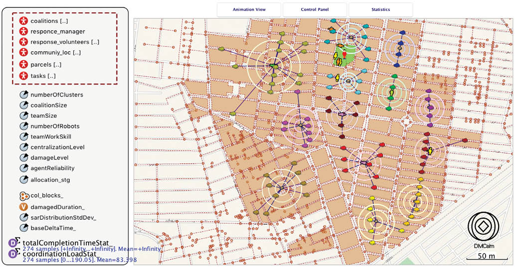
To develop the DMCsim system, an agent-based simulation (ABS), geographic information systems (GIS), machine-learning techniques, and optimisation algorithms were used. Using Anylogic software enabled the development of an ABS that inputs a large amount of data relating to team member characteristics and the disaster-operation environment. It also enables teams to include complex behaviours and interactions that emerge from individual agents with simple behaviours. The DMCsim works with machine-learning techniques such as clustering and market-based auctioning algorithms. The DMCsim data-analysis engine uses advanced statistical method, design of experiments (DOE) to test, evaluate and identify a robust design. An important contribution is a visual interface that allows users to interact with the system’s configuration and observe the operation and team movements.
The DMCsim offers the following benefits:
This paper outlines existing preparedness systems and disaster management coordination tools and the unique advantages of the DMCsim system. The methodologies and technologies used for developing the DMCsim system are described. A case-study scenario for an earthquake response operation in a neighbourhood in Tehran city shows the potential for improving the community-based emergency response.

In the U.S. emergency response includes elements such as preparedness, mobilisation, operation and resilience. This breadth of responsibilities and emergent dynamic tasks make emergency response complicated. A community’s resilience is dependent on the disaster’s disruption level and the community’s level of preparedness.
Several national preparedness systems have been established. These begin at the local level with community or neighbourhood emergency response volunteer teams. Some examples of these are Community Emergency Response Teams (CERTS) in the United States, the State Emergency Services (SES) in Australia and the Tehran Disaster Mitigation and Management Organisation (TDMMO) in Iran. All are overseen by a regional or Branch Disaster Response Team and, at the top of the responsibility pyramid, National Disaster Response Teams.
Various disaster coordination management systems have been developed to assist communities following disasters, such as NEMIS (FEMA 1998), DEFACTO (Schurr et al. 2005), ALADDIN (Jennings et al. 2006) and DRILSIM (Balasubramanian et al. 2006). However, communities that seek to conduct advance planning for a disaster, or that are already engaged in recovery efforts, face a number of challenges when using these systems.
The NEMIS framework was improved by FEMA but is constrained by context and does not offer adequate application mechanisms, such as disaster response coordination and task-allocation optimisation. The current NEMIS framework fails to address the pre-phase (contingency planning) stage of disaster response.
DEFACTO enables emergency managers to evaluate communications among, and the coordination of, the parties involved in a disaster operation but it is unable to use GIS technology. It therefore does not have a task-allocation-strategy element because it lacks location information for responders.
ALADDIN is a user-centric system that helps to design and model a decentralised system that can combine data from heterogeneous sources to carry out a certain action. Its drawbacks are that it lacks an interactive user interface and only receives input tasks as microtasks, such as search and rescue for a specific building.
DrillSim can simulate communications among responders who are also included in the flow of information and predefined task assignments. However, switching to a different disaster environment requires considerable system adaptation. In addition, it is not possible to test a first responder’s ability using different configurations.
In comparison, DMCsim can create numerous scenarios and test team performance in diverse configurations. It integrates GIS technology into simulation models and can create numerous scenarios in any community. Using the DMCsim, the user has the option to change the configuration manually and observe the virtual response operation and agents’ movements. A machine-learning technique, the K-means Clustering Algorithm, is applied in the simulation. This allows the user to cluster microtasks into macrotasks to make them more manageable.
The DMCsim conceptual model has four components. The first is the capability to input real disaster-scenario data into the system in a disaster situation when a massive amount of data is generated. This includes building information, structural damage, casualty reports, unusable roads, sizes of volunteer teams, available equipment, etc. The capability to input and use such data means the simulation scenario will closely resemble the real situation and allow the response manager to coordinate the response better.
The DMCsim next component is its configuration capabilities. Coordinating a response team involves many unknown factors and tasks, such as the time required to perform specific tasks, limited resources, unstable buildings and communication problems. Using constant or variable configuration factors in the DMCsim makes it possible to analyse the operation’s performance under different coordination configurations.
Efficient and consistent communication is essential for response teams to effectively complete their tasks. The DMCsim allows design of simulation scenarios that are more realistic and closer to an actual field operation and works in conjunction with the DMCsim task-allocation capability. Task allocation is perhaps the most important element. Effective task allocation has a direct effect on the efficiency levels of first-response teams. Because these teams must work in such a dynamic environment, effective task allocation requires the combination of coalition-formation and market-based auctioning algorithms. Evaluation of different task-allocation strategies in a disaster response scenario identifies each strategy’s value for the real mission.
The DMCsim system also has a DOE and optimisation capability. This is a built-in experimentation and optimisation framework using DOE techniques that allows emergency managers to test and evaluate possible scenarios for theoretical situations, search for the best team-design factors and determine the optimal response-operation scenario as quickly as possible.
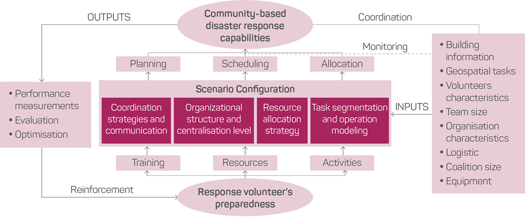
By gaining experience in a simulated environment, emergency response managers and emergency response volunteers can develop a greater sense of preparedness and be better equipped to make correct decisions prior to a disaster event. Figure 1 shows the framework for the evaluation of a community-based emergency response team’s performance in a response operation. This framework was adapted from the model used by TDMMO.

Scenarios created by the DMCsim are intended to evaluate disaster-operation performance in communities. An essential aspect of each scenario is the job structure and available tasks that must be performed during a disaster response.
To evaluate the DMCsim system the city of Tehran in Iran, was selected as a case-study scenario for a community-based disaster response operation. The recent World Disasters Report (IFRC 2014) listed Iran among the countries that has experienced the highest number of major seismic events and resulting fatalities. Numerous reports predict that Tehran will suffer from a major earthquake in the near future (Ashtari 2010). A model of building and human loss estimation for Tehran city in a severe earthquake scenario studied by Mansouri and colleagues (2010) estimated total structural damage of 72 per cent and a possible death rate of 33 per cent.
Input data to the DMCsim system can be classified in two groups: real data and simulation-generated data. Real input data consists of community data and volunteer information. Community data includes geographic and demographic data related to the response-operation field, such as each building’s location, structure and number of residents as well as roads, transportation networks, hospitals, etc. For this case-study modeling, the area vulnerability data collected by the Japan International Cooperation Agency (2000) was used. Information on volunteers, which consists of their preparedness, individual characteristics, skills, experience, team size and equipment are determined by the system’s user. In the real-case scenario, this detail could be replaced by existing information about response volunteers.
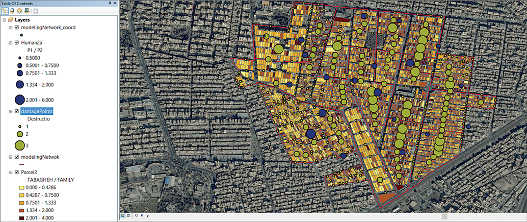
Simulation-generated data include the overall tasks and geospatially clustered tasks that emerge in the disaster environment. Task information consists of the reconnaissance, search, rescue, HAZMAT, medical and logistical tasks that are directly related to the real community data. DMCsim uses geospatial clustering to further segment the field of operations and, in turn, the relevant tasks become more manageable. The DMCsim can also leverage the potential loss estimation analysis generated by techniques offered by FEMA’s Hazus1 application. This is one of the GIS-based tools most frequently used by disaster managers. It offers methodologies and models that enable practitioners to estimate casualties from floods, hurricanes and earthquakes. In this study, the same methodologies that Mansouri and co-authors (2008) adopted to estimate casualties in their Tehran case-study disaster scenario are used. Figure 2 shows the case-study community-input data illustrated in the GIS platform.
The DMCsim requires geospatial information but domain problems must be defined. For the purpose of this study, a section of District 17 in Tehran, of approximately 0.62 sq km, was used. The area contains 41 urban blocks and 320 buildings.

The DMCsim system was validated and verified using a combination of methods such as verifying the problem domain by subject-matter experts, testing for system internal validity, analysing system sensitivity and comparing data generated by the simulation to results from the District 17 study conducted by Vafaeinezhad and co-authors (2009). To further test and evaluate the DMCsim system, we used DOE technique and designed a response-operation experimentation for the case study scenario. The experimentation result allows the performance to be optimised by screening design factors and choosing the best level for each.
The DMCsim result and evaluation for this case study experimentation demonstrates that if, for instance, an earthquake of level 1 intensity or damage level hit the study area and available responders were deployed to the operation field without any coordination strategy, the predicted response operation time would be about 1886 minutes. However, if the optimisation methods suggested by the system were used and the optimal coordination strategies were employed, the operation time would decrease to 1614 minutes. This is a 14.4 per cent improvement in operation performance. Performance also shows significant improvement for scenarios with earthquakes of levels 2 and 3. Performance improvement is 21.1 per cent and 19.8 per cent respectively (refer Table 1).
| Earthquake damage level | Predicted response operation time in minutes | Optimised response operation time in minutes | Potential operation performance increase |
|---|---|---|---|
|
Damage level 1 |
1886 |
1614 |
14.4% |
|
Damage level 2 |
2232 |
1861 |
21.1% |
|
Damage level 3 |
2550 |
2146 |
19.8% |
The DMCsim is a decision-support system that assists local emergency managers, practitioners and planners to test and select optimal coordination tactics for community-based disaster response teams prior to mounting an actual disaster response operation. A competent response manager should be able to design an appropriate team and effectively lead it to complete its assigned tasks within a minimum timeframe. By employing a DMCsim model, local community emergency managers could predict response-operation performance and take necessary steps to improve it. These include choosing appropriate coordination methods and task-allocation approaches and training volunteers based on specific job priorities.

The DMCsim is not solely for use in evaluating emergency and disaster scenarios; it can also be used in a number of other areas by private and public decision-makers, emergency managers and systems analysts. The system can be modified and extended, and can be very effective for the following purposes:
Ashtari M 2010, Statistical prediction of the next great earthquake around Tehran, Iran. Journal of Geodynamics, vol. 49, pp. 14–18.
Balasubramanian V, Massaguer D, Mehrotra S & Venkatasubramanian N 2006, DrillSim: a simulation framework for emergency response drills. In International Conference on Intelligence and Security Informatics, pp. 237–248. Springer Berlin Heidelberg.
Council of Australian Governments 2011, National Strategy for Disaster Resilience. Attorney-General’s Department. At: www.ag.gov.au/EmergencyManagement/Documents/NationalStrategyforDisasterResilience.PDF.
Federal Emergency Management Agency 1998, NEMIS Concept of Operations, report, FEMA Information Technology Services Directorate Operations Division, 15 May.
Federal Emergency Management Agency 2016, Community-Based Disaster Response Teams (CERT) Program. At: www.fema.gov/community-emergency-response-teams [27 October 2016].
IFRC 2014, World Disasters Report—Focus on Culture and Risk. At: www.ifrc.org/en/publications-and-reports/world-disasters-report/world-disasters-report/ [ 27 October 2016].
Isdr & Ocha U 2008, Disaster preparedness for effective response: guidance and indicator package for implementing priority five of the Hyogo Framework. United Nations, New York, Geneva.
Israel BA, Schulz AJ, Parker EA & Becker AB 1998, Review of community-based research: Assessing partnership approaches to improve public health, Annual Review of Public Health, vol. 19, no. 1, p. 173.
Jennings N, Ramchurn SD, Allen-Williams M, Dash R, Dutta P, Rogers A & Vetsikas I 2006, The ALADDIN project: Agent technology to the rescue. In Proceedings of the First International. Workshop on Agent Technology for Disaster Management.
Japan International Cooperation Agency 2000, The Study on Seismic Microzoning of the Greater Tehran area in the Islamic Republic of Iran, Final Report, Main Report, SSF JR 00-186.
Mansouri B, Ghafory-Ashtiany M, Amini-Hosseini K, Nourjou R & Mousavi M 2010, Building seismic loss model for Tehran. Earthquake Spectra, vol. 26, no. 1, pp. 153–168.
Mansouri B, Hosseini KA & Nourjou R 2008, Seismic human loss estimation in Tehran using GIS. 14th World Conference on Earthquake Engineering, Beijing.
Schurr N, Marecki J, Lewis JP, Tambe M & Scerri P 2005, The defacto system: Training tool for incident commanders. Paper presented at the Association for the Advancement of Artificial Intelligence.
Vafaeinezhad AR, Alesheikh AA, Hamrah M, Nourjou R & Shad R 2009, Using GIS to develop an efficient spatio-temporal task allocation algorithm to human groups in an entirely. In Computational Science and Its Applications—ICCSA 2009, Pt I. Springer-Verlag, Berlin.
Wong CY, Sakun B & Wong CWY 2011, The contingency effects of environmental uncertainty on the relationship between supply chain integration and operational performance, Journal of Operations Management, vol. 29, no. 6, pp. 604–615.
Mehdi Hashemipour is a Systems Engineering doctoral student at The George Washington University. His present research interests include the simulation modeling, machine learning techniques and data mining in the area of emergency management and disaster response coordination systems.
Dr Steven M. F. Stuban is a professorial lecturer at The George Washington University and a member of a standing Doctoral Advisory Committee.
Dr Jason R. Dever is a professorial lecturer at The George Washington University and also works as a Systems Engineer supporting the National Reconnaissance Office.
1 FEMA Hazus overview at www.fema.gov/hazus-mh-overview.