By Freya Jones, Bushfire and Natural Hazards CRC
Floods account for some of the worst natural disasters in Australia, costing millions of dollars in damage each year, and devastating communities. Research is testing a new approach to flood forecasting using satellite technology, which could help communities prepare for and deal with floods.
Predicting water depth and its velocity is vital for timely and accurate flood forecasting. The Bushfire and Natural Hazards CRC is undertaking research along the Clarence River in northern New South Wales using a hydrological survey to improve flood forecasting in the area.
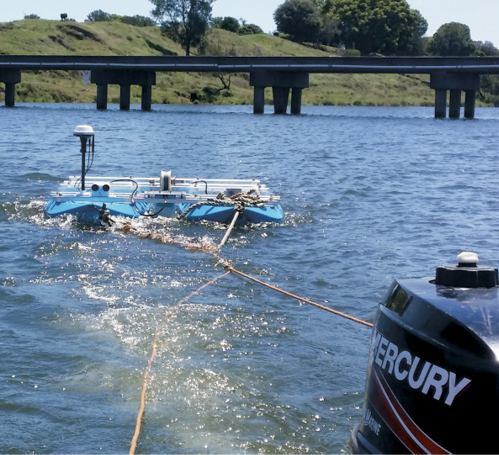
The research team has built a three-dimensional map of the river bed that can be maintained as conditions change. This has been done using a HydroSurveyor, including an echo sounder, Doppler velocity profiler and GPS antenna.
Associate Professor Valentijn Pauwels leads the CRC project, ‘Improving flood forecast skill using remote-sensing data’. He said the research offers significant benefit for communities in the Clarence Valley as it will be used to calculate the capacity of the river channel to deal with incoming flows.
‘With this information we can predict water depth and velocity at any point in the river valley.
‘The availability of timely and accurate flood forecasts allows for time-effective warnings and the implementation of evacuation plans. It also helps the set-up of safe recovery and storage areas,’ he said.
This forecasting relies on the data to predict the arrival time, water depth and speed of a flood using two main models, hydrologic and hydraulic. Associate Professor Pauwels said the models predict different aspects of a flood that are then applied together.
‘The hydrologic model determines the flow of water that is entering a river network using rainfall and catchment conditions, while the hydraulic model predicts how that water will travel downstream along the river system,’ he said.
Although these models have come a long way in terms of capabilities, they do not yet provide all the answers.
‘It is challenging to provide accurate flood warnings because of errors or uncertainties in the model structure and the model parameters,’ said Associate Professor Pauwels.
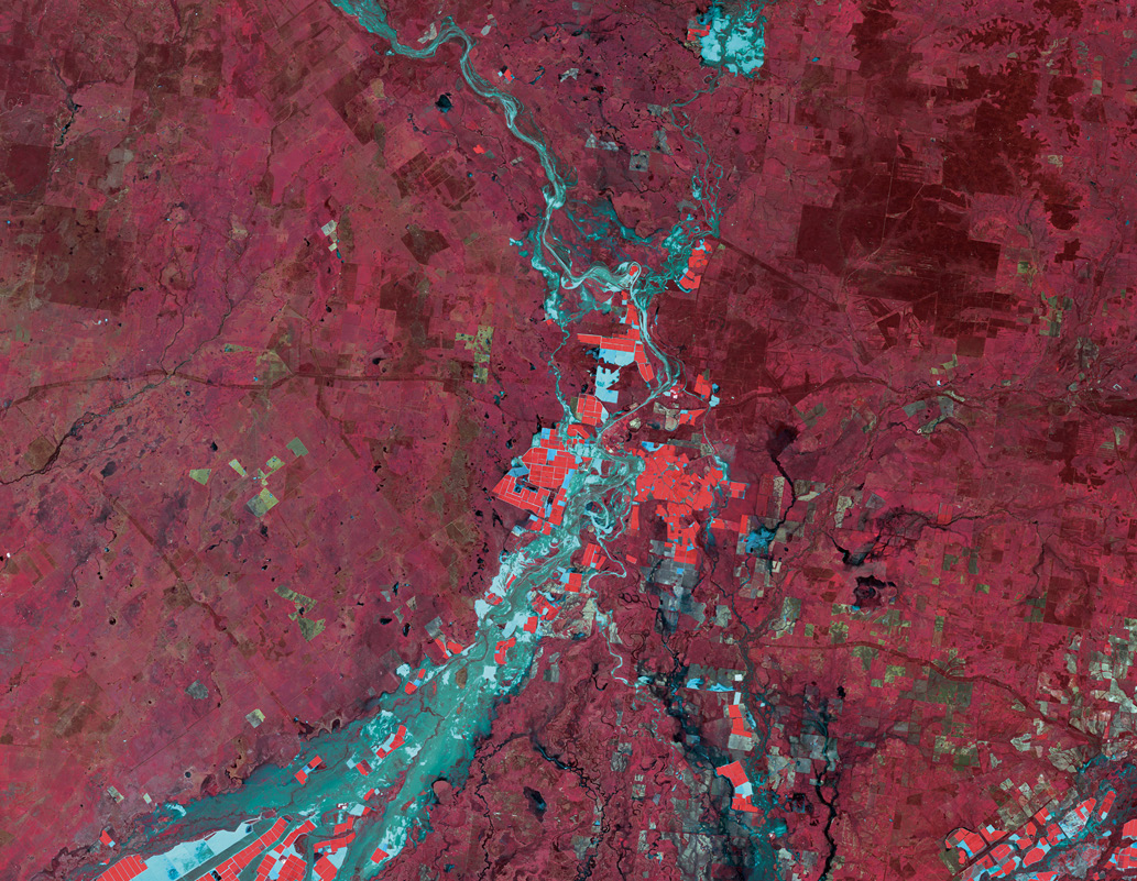
The research is looking at how remotely-sensed data can be assimilated operationally within existing models to improve the accuracy of flood forecasting. Remote sensing involves using satellite technology to capture information about a particular area from far afield. This means regions that are dangerous or inaccessible at ground level can have aerial data collected and used to fill in the gaps and assist with predictions.
Behind flood forecasting is a complex science that is constantly adapting to new technologies. The current models rely on rainfall stations to measure the amount of rain on particular catchments. The hydrologic model then calculates how much of that rainfall will be absorbed by the soil depending on current soil moisture levels.
The Bureau of Meteorology Manager of Policy and Strategy Unit, Soori Sooriyakumaran, is one of the project’s lead end-users and explains that there are particular limitations with existing methods.
‘There are parts of Australia where our rainfall station coverage is quite sparse due to the area being large and remote. Remotely-sensed rainfall data helps us understand the rainfall variability across such areas.
‘Remotely-sensed data also has its problems. But even with those it can add value to the input that goes into the modelling,’ he said.
Remotely-sensed soil moisture products have a great potential for calibrating and updating hydrologic models. The remote observations of flood extent and water levels can be used to correct and constrain, in real time, the prediction of the flooded area and depth generated by the hydraulic model.
A challenge to the project lies in combining the satellite data with data collected on the ground in a way that will minimise errors.
‘The spatial and temporal resolutions with which the on-ground and remotely-sensed data are observed are different so there are some challenges in bringing them together,’ Mr Sooriyakumaran said.
To overcome this and to minimise overall errors when combining the data sets, error characteristics of the data are analysed. The desired goal is to get precise and robust outcomes for flood forecasting and flood warnings.
‘What we’re trying to do with this research is to come up with the best combination of satellite and ground data so we can have as accurate as possible input and constraint information for the modelling’, he said.
The application of remotely-sensed data can be compared to a missing piece of the puzzle for flood forecasting. This brings together information from different sources to form the bigger picture. Mr Sooriyakumaran said this technology will only improve over time.
‘Satellite remote sensing is an expanding new field and we are going to have better and better data coming through in the future with higher resolution and higher frequency. This is one of the technologies that is going to keep improving flood forecasting into the future.
‘This research will be beneficial to emergency management as it supplies a more comprehensive depiction of conditions.
‘[The satellite data] could give us better situational awareness by showing areas under inundation.
‘To forecast future water levels we need good information on what is happening on the ground now, which we can present to the emergency services so they can plan their emergency response better,’ he said.
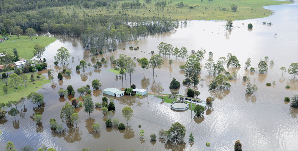
Clarence Valley Council Local Emergency Management Officer, Kieran McAndrew, said the river is the heart of the council area, which has been affected significantly by flooding in recent years. In 2009, 2011, 2012 and 2013 the river experienced serious floods.
‘The Clarence is the largest of all NSW coastal rivers in terms of catchment area and river discharge, which means flooding is part of life for the community of around 50,000 people,’ he said.
The Monash University-based research team comprises Associate Professor Pauwels, Professor Jeffrey Walker, Dr Stefania Grimaldi, Dr Yuan Li and Ashley Wright. They believe the research will have positive impacts on warnings for floods and contribute to lessening the potential damage and costs to communities.
Associate Professor Pauwels said, ‘It’s estimated that floods in Australia cost an average $377 million per year.
‘An improved flood forecasting system will add to the emergency management capability, thus reducing the flood-related financial costs and community distress’.
Mr McAndrew said the council wanted to support the research in any way they could.
‘The Clarence Valley community relies on warnings to prepare for imminent flooding, so there is a real benefit to be gained from the research,’ he added.
The next steps in the project will be to bring all the existing data together with the new satellite information and put it into operational use.
‘Up until now we have focused on collecting the data. From here we will start improving the models,’ said Associate Professor Pauwels.
This process will be made easier using the recently-upgraded platform for modelling, Hydrological Forecasting System, from the Bureau of Meteorology. This platform uses a framework that allows users to easily plug in new models said Mr Sooriyakumaran.
However, Mr Sooriyakumaran believes that the benefits of this research will not be immediate.
‘We are not expecting dramatic changes to happen overnight. They will take time.
‘But as technology advances and this research is applied to an operational setting, the true impact will be realised.
‘The upgrade of our flood forecasting modelling system means we are able to bring research learnings into operations much more readily. This is a capability we did not have before,’ he said.
Find out more about this research at www.bnhcrc.com.au.

