By Brenda Leahy, Communications Officer, Australasian Fire and Emergency Service Authorities Council
Tonimbuk, population 317, is about 90km east of Melbourne beside the Bunyip State Forest. It is one of Victoria’s many pretty and, sometimes, dangerous places. In summer, when heat, wind and fuel conditions converge into severe fire weather, the natural beauty of the densely-forested landscape turns Tonimbuk into a place of high bushfire risk.
Local residents, Mike and Elaine Harrison, like so many others, co-exist with the risk because Tonimbuk is ‘home’.
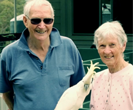
Image: Tom Lowe, Polygraph Productions
Mike and Elaine Harrison say a sense of connection to landscape is part of their response to bushfire risk.
Filled with 40 years of memories, of family, friends, lives lived and lost; home for the Harrisons is much more than the house, possessions or a place on a map. It’s about deep connections with the landscape, beyond the front gate, to the local town hall, the scrubby ridges, pastures and thickly forested hillsides.
‘No matter where you are, when you come back it’s like putting on a good old comfortable coat. You’re home,’ explains Mike Harrison. His story of home within his beloved landscape features in an innovative, online training and development toolkit published by the Australasian Fire and Emergency Service Authorities Council.
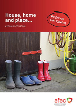
The House, Home and Place: A Visual Mapping Tool Kit for fire and land managers uses stories to help explain why people want to live in fire-prone communities. It helps illustrate some of the values and beliefs that shape their connections to home and place.
The toolkit is based on the research of Professor Ruth Beilin and Dr Karen Reid of the University of Melbourne from their ‘Social Construct of Fuels in the Interface’ project for the Bushfire CRC.
In their studies, the researchers found that emergency services agencies could benefit from ‘stepping into the shoes’ of local residents to understand their perspectives on bushfire in the landscape and their responses to risk. Factors investigated included what people meant by ‘house’, ‘home’ and ‘place’ and what things they valued in terms of their homes and communities, and why.
According to Dr Reid, using this local knowledge and insights would help agency staff to support people to anticipate and reduce the risks to their homes and communities.
Mike Wouters, one of the project’s advisors from the South Australia Department of Environment, Water and Natural Resources (DEWNR), wanted to understand why residents did not appear to assess hazard and risk in the same way as agencies, or respond as they had expected to general fire safety messaging. The key question was: What did people value most in their homes and communities?
A place-based approach, according to Dr Reid, helped explain how residents attached meaning to environments in their everyday lives and how this influenced their thinking about risk.
‘The field work with our colleagues from DEWNR confirmed that people were not ignorant of bushfire risk.
‘It showed that their understanding of risk was far more complex, reflecting their sense of self and how they individually valued assets. For example, trees, wildlife or buildings were inseparable from the broader landscape context. This laid the ground work for the development of the toolkit,’ she said.
The findings highlighted that people’s sense of home and place extended well beyond the house to being part of the local landscape, according to Mike Wouters. This had implications for bushfire education as, traditionally, he says, some fire safety messaging had focused on the ‘house’ and the structural or physical aspects of preparation, such as cleaning gutters and making fire breaks.
During the project, the researchers also held workshops with the South Australia Country Fire Service, the Tasmania Fire Service and Victorian fire and land management agencies, the Country Fire Authority, Department of Environment Land Water and Planning, Emergency Management Victoria and Parks Victoria.
The House, Home and Place: A Visual Mapping Tool Kit features a package of videos, including personal stories and a range of printable resources on how to use and apply the information.
The toolkit is essentially a visual mapping method and interview technique delivered in a workshop format. The method can be used by anyone interested in working with communities to strengthen capacity and to mitigate and recover from natural hazards.
Residents work in small groups and are helped to sketch, or ‘mud map’, their home within the local environment and to reflect on how they live within and use that space every day. As they talk, draw and interact, they are encouraged to consider hazards and risks, such as bushfire.
A key benefit of this method, according to Dr Reid, is that it can start productive conversations about risk and how to manage it. These free-flowing conversations, she says, reveal insights that cannot be gleaned from typical question-and-answer style interviews or surveys.
‘The process of visual mapping helps unlock deeper-held intuitive ways of knowing. It helps explain why certain things are important, and provides an opportunity to pause and reflect on the decisions we make and the actions we take. In this way, the deeply held assumptions we make about the landscape are reflected right back at you on the paper.
‘It doesn’t matter whether you’re a local, a land manager, firefighter or scientist, we all draw on our intuitive ways of knowing, as well as our rational knowledge.
‘But the intuitive is much harder to access than the rational way of knowing, because it’s deeply embedded in our thoughts and assumptions. By going through this process we can understand better where people are coming from,’ Dr Reid said.
Communication consultant, Tom Lowe, was engaged to translate the research into a tool for practitioners. He used video storytelling and narrative to put a human face on complex and abstract concepts.
‘Managers and practitioners often talk about people’s values in broad terms. This may be because everyone has a slightly different take on the world, and it would be almost impossible to take into account the depth and breadth of views that are out there.
‘As a result, we tend to gloss over the reasons for people’s connections to place in an attempt to avoid overcomplicating decision making,’ said Mr Lowe.
In developing the toolkit materials, he aimed to demonstrate what connects people to their surroundings as well as bring to the fore the stories behind people’s view of the world.
‘Fire and land managers don’t necessarily need to remember every individual story, or respond to everyone’s demands, but I do think it is important to be aware of the richness of experience that lies behind each story.
‘By starting from the ground up, and engaging in discussions with local people about their connections to place, practitioners should be able to extract a more detailed sense of where people agree and where they disagree.
‘The toolkit materials will not provide decision-makers or communities with all of the answers, but they should give people the confidence to start a discussion and not be afraid to listen to people’s stories,’ Mr Lowe said.
Access the toolkit at http://tinyurl.com/jdp89bo
Other related resources at www.bushfirecrc.com/research/event/2014-drivechange-06

