Improved interdisciplinary disaster risk reduction has been a consistent theme highlighted in the Hyogo Framework for Action 2005-20151 and its successor, the Sendai Disaster Risk Reduction Framework2. The complexity of elements contributing to disasters requires that effective risk management extends beyond individual disciplines to be effective, through integrated or interdisciplinary approaches (van der Waldt 2009). Many recent initiatives have directly sought integrated action (Dahms 2010, Buckle 1998, Panton & Jonhston 2006). In Australia, the notion of shared responsibility applies not only to emergency management agencies, but requires action by different sectors including government, business, communities and individuals (COAG 2011).
Due to the multidimensional character of bushfire occurrence, intensity and progression, different disciplines and skills are required to assess and treat interdependent risk factors (Menoni 2006). Of the many approaches employed, urban planners and designers can have a substantial influence on the level of damage caused by bushfire and may lessen risk by carefully assessing fire likelihood and consequences to decide between avoidance of high-risk areas or reducing risks to an acceptable level. Urban planning can shape settlements to be ‘spatially and functionally’ arranged to manage bushfire risks (Groenhart, March & Holland 2012). For instance, in Victoria, new bushfire policy from late 2011 sought a more integrated approach applying the precautionary principle and a proactive planning approach (Bond & Mercer 2013). Planning systems are uniquely placed to shape the relationships between disciplines and to integrate their activities, often providing a ‘bridge’ between other risk treatments. Planning professionals can potentially draw on understandings of risk from multiple knowledge sets when considering the bushfire risks of a site or settlement, such as topography, fuel load, likely fire behaviour and interactions with structures to undertake risk assessments and treatments via urban planning. However, these understandings cannot be determined by any one discipline. There is a need for integration of many disciplines to effectively treat bushfire risks.
This paper identifies the main disciplines, skills and activities involved in meaningfully conducting a bushfire risk assessment and treatment, particularly in Victoria. First, interdisciplinarity is examined as a concept. This is followed by a research method and a description of the integrated approach used in planning processes in Victoria. Three broad skill sets are then set out and discussed. It is concluded that while urban planning regulations now encourage interdisciplinary action, planners and other professionals need to develop skills that bridge these broad categories.
In order to consider how disciplines integrate, develop and apply knowledge, it is necessary to first understand the meaning of ‘discipline’. A discipline is a specific field of study or knowledge joined with the ability to conduct tasks proficiently. Interactions between different disciplines can be multidisciplinary, interdisciplinary or transdisciplinary.
In the context of risk management, interdisciplinary approaches are highly desirable because they have the capability to creatively ‘integrate knowledge and modes of thinking in two or more disciplines or established areas of expertise’ to explain a phenomenon, solve a problem and create a product (Krohn 2010). For bushfires, shared responsibility requires the management of risks through shared skills and actions (O’Neil & Handmer 2012) between communities, industries, fire agencies and government authorities, where individual action and responsibility are integrated. This is a form of interdisciplinarity via an integrated and interoperable approach that includes pre-emergency actions. Interoperability is the ability for diverse systems and organisations to work together or to exchange information (Eslami-Andargoli, Bernus & Kandjani 2013). The question then remains how these disciplines and concept of responsibilities are dealt with and are there apparent ways with which they are dealt.
A case study of Victorian planning for bushfire risk management appraised the diverse skills, disciplines and activities involved in bushfire risk assessment and planning. In particular, the Bushfire Management Overlay (2011, 2014), which seeks an integrated approach, was examined. Three data sources were used:
Clause 52.473 of the Victorian Planning Provisions was analysed to identify skills necessary for a bushfire risk assessment in a statutory sense. The ‘assessments’ examined encompassed both the analysis of risks and the proposal and ‘assessment’ of the appropriateness of treatments proposed to reduce these risks. The results were themed around 12 areas of consideration (Table 1). The interviews with bushfire experts, working in public and private sectors, assisted in confirming information.
Table 1: Areas of knowledge and skill derived from Clause 52.47 for exercising judgement in terms of bushfire risk reduction (includes assessment of initial risks, and effectiveness of treatment/s proposed).
| Clause 52.47 | Fire science* | Forest science* | Slope | Settlement type/location | Vegetation location/ type | Site access/ layout | Bushfire hazards/risks | Site design | Building design | Bushfire protection measures** | Bushfire Attack Level | Alternative method | ||
|---|---|---|---|---|---|---|---|---|---|---|---|---|---|---|
| High | Moderate | High | Moderate | |||||||||||
Dwellings in existing settlements |
No |
Yes |
No |
Yes |
Yes |
No |
Yes |
Yes |
Yes |
Yes |
No |
Yes |
Yes |
No |
Landscape, siting and design |
Yes |
No |
Yes |
No |
Yes |
Yes |
Yes |
Yes |
Yes |
Yes |
Yes |
No |
No |
No |
Defendable space and construction |
No |
No |
No |
No |
Yes |
No |
Yes |
No |
No |
Yes |
No |
No |
Yes |
Yes |
Water supply and access |
No |
No |
No |
No |
No |
No |
No |
No |
No |
Yes |
No |
No |
No |
No |
Subdivision |
Yes |
No |
Yes |
No |
Yes |
Yes |
Yes |
Yes |
Yes |
Yes |
No |
Yes |
Yes |
Yes |
Table 1 demonstrates 12 areas of knowledge and skills in which disciplinary activity, data collection and analysis occur for judgement in land-use planning bushfire assessments. The themed areas were developed on the basis of the main skill sets required rather than existing disciplinary practice boundaries. The knowledge and skill requirement of these 12 areas were compared against the three distinct pathways identified in Clause 52.47 for preparing and assessing a planning permit application. The pathways provide a streamlined approach for dwellings in existing settlements (Pathway 1, Clause 52.47-1), a more detailed approach for other types of development (Pathway 2, Clause 52.47-2.1 and 52.47-2.2), and special provisions to guide the subdivision of land (Pathway 3, 52.47-2.4). Clause 52.47-2.3 requires consideration for water supply and access to assist in protecting property and is required to be incorporated in all three pathways.
The table shows that, generally, all the areas of knowledge and skills are crucial for preparing a permit application or conducting a planning permit assessment in relation to all of the three pathways. Typically, Pathway 1 (Clause 52.47-1) requires nine out of 11 areas of knowledge and skills. These are fire science, forest science, slope, vegetation location and type, site access and layout, bushfire hazards and risks, site design, bushfire protection measures and bushfire attack level. Pathway 1 requires moderate levels of fire science, forest science knowledge, and skills as it is within an existing settlement deemed appropriate for development. In addition, there is no requirement of in-depth consideration of the proposed development’s settlement type and location as the area is zoned for residential purposes. Furthermore, no understanding is required in the area of building design for a planning permit and alternative method. In the case of Pathway 2, (Clause 52.47-2.1 and Clause 52.47-2.2), all the 12 areas of knowledge and skills are necessary for making a judgement on the bushfire risks of the proposal. Importantly, unlike Pathway 1, in Pathway 2 the required level of fire and forest science knowledge and understandings are high, as the proposed development is not located in an existing settlement. Furthermore, for Pathway 3, only 11 areas of knowledge and skills are essential. Similar to Pathway 2, a high level of fire science and forest science understanding and skills are essential. Unlike Pathway 2 and similar to Pathway 1, no consideration of building design is required at the planning stage.
Once the 12 areas were categorised, these were then considered within the following themes of:
Before discussing these results, it is appropriate to consider the planning systems role in Victoria in facilitating interdisciplinary approaches.
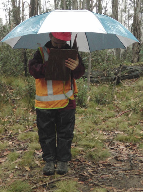
Assessors must classify vegetation during a bushfire risk assessment.
Several regulatory requirements via building and planning regulations that seek to treat bushfire risks were observed in Victoria’s planning system. These are based on zones and overlays that require new development to be built in accordance with relevant regulations. After the Black Saturday bushfires in 2009 the bushfire Integrated Planning and Building Framework in Victoria4 was introduced to ‘strengthen the consideration of bushfire at different stages of the planning process and better integrate the planning and building systems’ (Groenhart, March & Holland 2012).
The Bushfire Management Overlay5 (BMO) is integrated into the Victorian planning scheme at Clause 44.06, regulating land development organisations to manage bushfire risks. The BMO emphasises primacy of human life and the use of the precautionary principle when considering bushfire risks. In particular, the BMO triggers the need for a detailed planning permit for developments and requires that new development include appropriate bushfire protection measures. These include building siting, defendable space, and emergency vehicle and water access. Integration of different referral authorities is required in these processes. For bushfire planning assessment, the Country Fire Authority is the key referral authority that considers a range of bushfire and other matters such as firefighting access, fuel separation, vegetation management, habitat retention, subdivision size and visual amenity. Managing bushfire risk involves a large number of issues in a wider policy context and requires good integration of different fields and experts.
The preliminary stage of the assessment process includes establishing site and surroundings background information. Fundamental or background information includes vegetation type and location, topography, settlement type, location of the area, site access, existing land management activities, and site orientation (Figure 1). Generally these are mentioned in all the three pathways. In particular, Clause 52.47-1, Clause 52.47-2.1 and Clause 52.47-2.4 of the planning scheme require that the location, siting and layout objectives are met, paying heed to the context of the surrounding area.
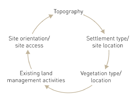
Part of the bushfire risk assessment requires vegetation to be classified into one of seven categories defined by Australian Standard 3959-2009. Classifiable vegetation constitutes vegetation that presents a bushfire hazard within 150 metres of the development. The assessor must be able to classify the vegetation correctly and measure the distance and location of the classifiable vegetation from the site boundary or the building footprint. Understanding the topography of the land is also important as it has a direct influence on the severity of a bushfire. Fire generally moves faster uphill. As a rule of thumb, for every 10 degrees upslope, fires will double in speed (CFA 2012). The slope to be measured is under classifiable vegetation and assessors should calculate the slope in degrees using a clinometer on site. This is detailed in the Fire Safety Officer documentation of vegetation type, location and slope details.
Determination of settlement type, location of the area, site access, existing land management activities and site orientation provides understandings of site context. Evidence shows that less than five per cent of bushfires cause more than 95 per cent of damage (Institute of Foresters of Australia 2009). This is because there is a strong link between fire progression and population patterns with increasing numbers of dwellings in proximity to forests. In a residential settlement the fire may have more catastrophic impact on human life and property, as compared to those in open grasslands, depending on the characteristics of structures and any risk reduction activities used, such as fuel reduction on neighbouring properties.
An assessor needs to exercise judgement and to draw on additional expert opinion as required. Consultants interviewed in complex cases said they relied on the expert opinions of others to augment, validate or support their findings. An experienced bushfire consultant recommended to ‘go out there first and if there are any complex issues then get in other experts’.
For example, a statutory planner might arrange an arborist to assess the site in conjunction with Country Fire Authority assessments. Cross-disciplinary advice and knowledge was apparent as a key aspect of risk assessment.
The main aim of the bushfire risk assessment is to achieve outcomes that successfully manage risk. The County Fire Authority (2012) affirms that critical factors that affect fire intensity include ‘the length of time a fire has to grow and develop, the quantity, arrangement and continuity or fragmentation of vegetation cover and the topography the fire is burning within’. Developing knowledge, skills and understanding in fire and forest science provides an understanding of bushfire risks. Fire behaviour, fire intensity, forest growth and bushfire hazards are topics within this type that develop knowledge about bushfires risks (Figure 2). Therefore, a moderate to high level of understanding in this area is mentioned in each of the three pathways.
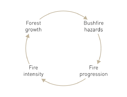
Understanding potential fire behaviour is an integral element of fire management and guides many fire-management decisions. The core skill in relation to the likely fire behaviour is to analyse the probability of ignition or burning (likelihood), flame length (intensity), and effects in likely weather scenarios (Miller & Ager 2013). A general understanding of how a bushfire behaves, from widespread grassfire to intense hot-burning wildfire, and destroys structures is crucial. Fire science is complex and requires the broader context to be considered, such as the possibility for long fire runs versus lower intensity fragmented fires and fire fronts, and topographical or other factors in the wider landscape. Fire behaviour understandings can also be augmented by information of an area’s fire history and assessment of the fuel hazard development over time.
Vegetation is the primary source of fuel for a bushfire until it transitions into an urban area, when structures may provide fuel for fire progression. Assessors need to correctly identify the vegetation type and the likely growth over time, taking into account possible modification of the vegetation and its likely future state. For instance, farmland vegetation may be disturbed because of the agricultural regime in force and is likely to remain disturbed, except if changes to farming practices occur. In cases where sites were complex, the case study showed that many parties seek expert advice, for example from a fire and forest science expert. A statutory planner reflected that, ‘the firm produces better bushfire management statements when it has a multidisciplinary approach, which means they have professional networks they are using or working in collaboration, as compared to someone working in isolation’.
The ability to integrate multiple data and information sources to develop options for a given site that treats risks is integral to planning and design skills in this area. As shown in Figure 3, design response and risk treatment skills include bushfire protection measures, land management, bushfire attack level assessment and the use of alternative methods. The requirements for design responses are discussed in all the three pathways in Clause 52.47 to ensure development only occurs where risk has been reduced to an acceptable level.
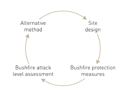
Professional skills in carrying out iterative processes of concept development, testing and evaluation while complying with regulations were observed as a process of selecting the most appropriate risk treatment option. A consultant mentioned that the option selected needs to be ‘a feasible outcome’ that fits into the wider context. In parallel, professionals also need to understand and apply land management measures, such as removal of vegetation and the potential use of environmental offsets and legal agreements for ongoing vegetation management. An additional skill in developing a design response is the calculation of bushfire attack level. This includes skills in calculating and designing defendable space or asset protection zone areas and, occasionally, bunkers in extreme situations. Areas of separation around structures reduce flame contact and radiant heat effects as well as providing external areas for active defence or exit from buildings should it become necessary. A bushfire consultant highlighted that ‘sometimes I act as an educator, as the clients do not understand the risks and management issues’.
The assessor’s role is to deliver solutions that ultimately are consistent with the regulatory standards, that will be granted permits, and also meet client needs. In doing so, they need an understanding of the risk factors associated with developments and the corresponding treatments. This analysis shows that assessors offering services and advice in this area need to carry out an analysis of background information, propose options with calculated defendable space and bushfire attack level ratings and choose one that has an acceptable level of risk in the context of the other treatments being used.
This research shows that the nature of bushfire management is complex and includes physical factors, meteorological conditions, building elements, and human behaviours. Of the many treatments available urban planning can play a key role in improving the survival of dwellings. In states such as Victoria that use all-hazards, all-agencies approaches there is a challenge for assessors undertaking land-use planning bushfire assessments, such as planners, ecologists, foresters and fire officers, to develop a deeper understanding of bridging multiple aspects of bushfire risks and the multiple ways these can be minimised. The research shows that key skill sets, many of which are interdisciplinary, are required for assessors to better understand and treat bushfire risks. The theme that emerged from this research is that while the planning regulations do trigger and facilitate interdisciplinarity action to some extent, assessors themselves need to develop skills in this area to be effective contributors to that interdisciplinarity.
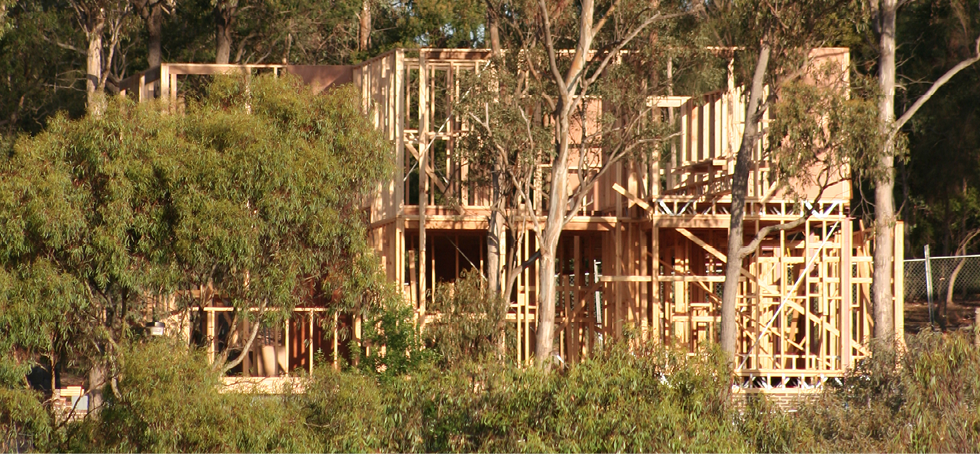
Rapid development in city fringe areas highlights the vital role urban planning can play in improving the survival of dwellings in bushfire events.
Buckle P 1998, Re-defining community and vulnerability in the context of emergency management, Australian Journal of Emergency Management, vol. 13, no. 4, pp. 21-26.
Bond T & Mercer D 2014, Subdivision Policy and Planning for Bushfire Defence: A Natural Hazard Mitigation Strategy for Residential Peri-Urban Regions in Victoria, Australia, Geographical Research, vol. 52, no. 1, pp. 6-22.
Council of Australian Governments 2011, National Strategy for Disaster Resilience. Attorney-General’s Department.
Country Fire Authority 2012, Planning for Bushfire Victoria (Version 2), Melbourne: Country Fire Authority.
Department of Transport, Planning and Local Infrastructure 2014, Victoria’s bushfire planning and building framework, Victoria: Victorian Government. At: www.dpcd.vic.gov.au/planning/plansandpolicies/bushfire-planning-and-building/framework [22 June 2014].
Dahms T 2010, Resilience and risk management, Australian Journal of Emergency Management, vol. 25, no. 2, pp. 21-26.
Eslami-Andargoli A, Bernus P & Kandjani H 2013, Analysis of Interoperability Issues in Queensland Disaster Management System, 15th International Conference on Enterprise Information Systems (ICEIS) Proceedings. SciTePress.
Groenhart L, March A & Holland M 2012, Shifting Victoria’s emphasis in land-use planning for bushfire towards a place-based approach, Australian Journal of Emergency Management, vol. 27, no. 4, pp. 33-37.
Institute of Foresters of Australia 2009, Submission to the 2009 Victorian Bushfires Royal Commission. At: www.forestry.org.au/pdf/pdf-public/Submissions/Vic%20Bushfires%20RC%20submission%2018%20May%202009%20V2%20-%20page%20numbered.pdf [26 March 2014].
Klein J 2010, A Taxonomy of Interdisciplinarity, in Frodeman R, Klein J & Mitcham C (Eds.) The Oxford Handbook of Interdisciplinarity, pp.15-19. Oxford University Press.
Krohn W 2010, Interdisciplinary Cases and Disciplinary Knowledge. In Frodeman R, Klein J &. Mitcham C (Eds.), The Oxford Handbook of Interdisciplinarity. Oxford University Press.
Marinova D & McGrath N 2004, A transdisciplinary approach to teaching and learning sustainability: A pedagogy for life, Teaching and Learning Forum. At: http://otl.curtin.edu.au/tlf/tlf2004/marinova.html [13 June 2014].
Menoni S 2006, Introducing a transdisciplinary approach in studies regarding risk assessment and management in educational programs for environmental engineers and planners, International Journal of Sustainability in Higher Education, vol. 7, no. 3, pp. 309-321.
Miller C & Ager AA 2013, A review of recent advances in risk analysis for wildfire management, International Journal of Wildland Fire, (22), pp. 1-14.
Panton D & Jonhston D 2006, Disaster Resilience: An integrated approach, USA: Charles C Thomas.
Park J-Y & Son J-B 2010, Transitioning toward transdisciplinary learning in a multidisciplinary environment, International Journal of Pedagogies and Learning, vol. 6, no. 1, pp. 82-93.
O’Neil SJ & Handmer J 2012, Responding to Bushfire Risk: the need for transformative adaption, Environmental Research Letters, 7, pp. 172-178.
van der Wald G 2009, Public Management and Disaster Risk Reduction: potential interdisciplinary contributions, Journal of Disaster Risk Studies, vol. 2, no. 1, pp. 14-27.
Dr Alan March is Associate Professor in Urban Planning in the Faculty of Architecture, Building and Planning at the University of Melbourne and is Director of the Bachelor of Environments. His research includes examination of the practical governance mechanisms of planning and urban design and the role of urban planning in reducing disaster risks.
Yogita Rijal is an urban planner who has worked in the private sector in Victoria and as a researcher in the Faculty of Architecture, Building and Planning at the University of Melbourne. She has an undergraduate degree in Architecture and a Master of Urban Planning from the University of Melbourne. She has practical expertise in statutory planning and project management.
1 Hyogo Framework for Action 2005-2015. At: www.unisdr.org/2005/wcdr/intergover/official-doc/L-docs/Hyogo-framework-for-action-english.pdf.
2 Sendai Disaster Risk Reduction Framework. At: www.unisdr.org/we/coordinate/sendai-framework.
3 Victorian Planning Provisions, Clause 52.47. At: http://planningschemes.dpcd.vic.gov.au/schemes/vpps/52_47.pdf.
4 Integrated Planning and Building Framework for Bushfire in Victoria. At: www.dtpli.vic.gov.au/__data/assets/pdf_file/0019/231625/Integrated-planning-and-building-framework-WEB.pdf.
5 Bushfire Management Overlay . At: http://planningschemes.dpcd.vic.gov.au/schemes/vpps/44_06.pdf.

