Nathan Maddock, Communications Officer, Bushfire and Natural Hazards Cooperative Research Centre, tells how researchers are investigating where extreme water levels could impact Australia's coast.
In August 2014 a container ship in Fremantle Harbour, Western Australia broke away from its moorings and collided with the bridge on the Perth-to-Fremantle train line, closing the bridge for two weeks. Unknown to most casual observers, this part of the coast had been hit by a meteorological tsunami, or meteotsunami for short. The strong currents of the meteotsunami broke the ship’s moorings and the increased water height allowed the ship to travel over the sandbar separating the harbour from the Swan River.
Along Perth’s waterfront, meteotsunamis, in combination with high tides and storm surges, have led to flooding of the Swan River. June 2012 saw the highest water level recorded in 115 years, which resulted in the closing of the Kwinana Freeway.
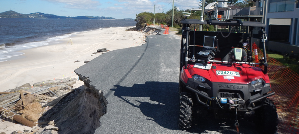
The Office of Environment and Heritage NSW assess erosion at Jimmy’s Beach, NSW, after storm damage in April 2015.
Professor Charitha Pattiaratchi, an oceanographer at the University of Western Australia (UWA) said, ‘Most people do not know that a meteotsunami has occurred. They think it’s just a high tide or a king tide. But it’s the stacking up of the events that causes problems.
‘The timing is really important. If a meteotsunami occurs at low tide there is negligible impact. In contrast, if it happens close to the high tide, it will lead to high water levels. This is what happened at the Perth waterfront in June 2012,’ he said.
Around 85 per cent of Australia’s population is within 50 kilometres of the coast, along with a significant proportion of key assets and infrastructure. Yet these coastlines, and the communities that call them home, are exposed to a range of natural hazards that can cause severe damage. Research underway by the Bushfire and Natural Hazards CRC will improve the knowledge of such hazards.
Professor Pattiaratchi is leading the CRC study, with fellow UWA researchers, Drs Sarath Wijeratne, Ivan Haigh, Matt Eliot, Ivica Janekovic and Yasha Hetzel.
Professor Pattiaratchi said that extreme water levels can result from the combination of different physical processes including tides, storm surges, tsunamis (both seismic and meteorological) as well as seasonal and inter-annual mean sea level variations. Extending the understanding of meteotsunamis and their risk around the country is a key focus of the study.
‘Meteotsunamis are relatively common phenomena, but not well understood. We could consider Western Australia a global hotspot for meteotsunamis with 25 being recorded in 2014,’ Professor Pattiaratchi said.
So what is a meteotsunami and how does it differ from a tsunami caused by an earthquake?
‘In Western Australia, and across most of Australia, meteotsunamis are caused by the passage of thunderstorms or very fast travelling frontal (weather) systems. These weather systems result in a change to the atmospheric pressure and, if the propagation of the pressure disturbance matches the speed generated by a wave, then a meteotsunami could occur.
But not every thunderstorm will cause a meteotsunami.
‘If the passage of the storm or weather system is too slow, or too fast, then you will not have that resonance. But it is more likely if a thunderstorm is travelling parallel to the coast where a range of water depths is experienced,’ Professor Pattiaratchi said.
Many people would not be aware of meteotsunamis because, compared to a seismic tsunami that is often associated with large, destructive waves, meteotsunamis do not necessarily cause loss of life.
‘Meteotsunamis are not that large. In Australia the maximum height is around one metre,’ noted Professor Pattiaratchi.
But that does not mean there is not a risk. When the tidal range is factored in, one metre can become very significant.
‘We know Western Australia is at risk, but we want to understand what other areas of the country are at risk too. This study is about extending our knowledge around the entire coastline to gain a better understanding of their occurrence and, therefore, risk,’ he said.
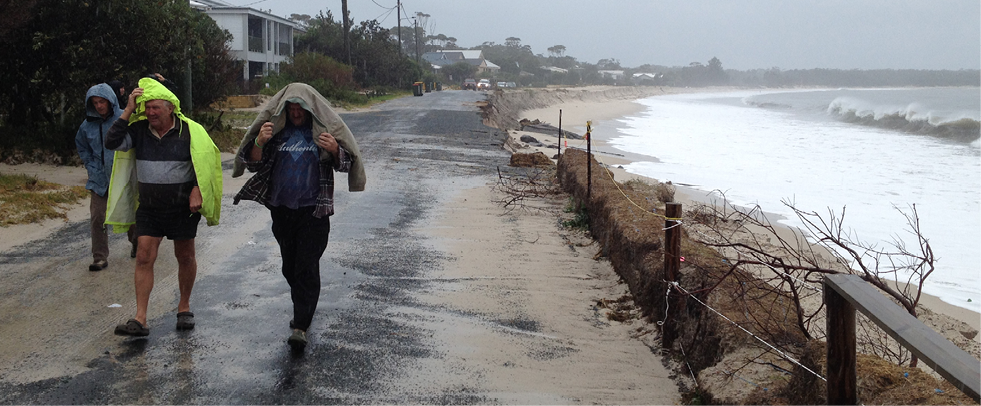
Locals brave the elements during April’s east coast low.
This research documents the risks posed by meteotsunamis and also the risk associated with a combination of different processes such as tides and storm surges generated by tropical and extratropical cyclones. A computer model allows the research team to map the coastline around the country, highlighting where extreme water levels could occur. This provides an accurate assessment of potential impacts on the coastline, leading to better emergency planning and management.
A key aspect of the research is not just about finding the areas that might have problems, but being able to tell when these extreme water levels could occur.
‘We will analyse the identified problem areas to find out under what specific conditions problems occur. This will allow coastal engineers, emergency managers and planners to be better prepared with accurate estimates of extreme water levels,’ Professor Pattiaratchi said.
This outcome is precisely what CRC end user Dr Martine Woolf, Section Leader for Hazards and Risk Application and Infrastructure at Geoscience Australia, believes is needed.
‘We don’t really have a good handle on the likelihood of extreme water heights occurring,’ she said.
Localised studies have been undertaken at various locations, but it is the national aspect of this project that appeals most to Dr Woolf.
‘It is vital that the whole country is modelled using a consistent approach. Professor Pattiaratchi and his team are trying to come up with data on what is ultimately a very localised hazard, but in such a way that you can compare it across the country, from different types of events, from meteotsunamis to tropical cyclones, to extra-tropical east coast lows.
‘It will be a unique, national dataset and benchmark point across the nation, identifying where the issues are, even if they have not yet been experienced at that location,’ Dr Woolf said.
Ultimately, these outcomes will strengthen the resilience of coastal communities and infrastructure.
Find out more about this research at www.bnhcrc.com.au.

