
Australia is prone to the devastating impacts of bushfires and other natural hazards. Climate change and increased global warming means extreme weather events such as bushfires, floods and heatwaves are predicted to increase in both frequency and intensity (IPCC 2012). Adequately preparing for disasters can dramatically reduce the risk to life and assets (Paton 2003). Yet, despite efforts to educate communities with relevant and up-to-date information, research has shown individuals in at-risk communities still may not actively engage in risk reduction activities (Frandsen 2011). Innovative approaches are needed to involve communities in disaster preparation to reduce risk and build resilience. Social media and other online geographic information communication technologies are increasingly providing opportunities to connect communities. The role of these technologies in disaster response has been well-established in recent years, however, research into their utility in the pre-disaster phases of the emergency cycle remains relatively limited (Haworth & Bruce 2015). This article presents findings of a study examining the potential role of social media and other online geographic information technologies in fostering community engagement in bushfire preparation in Tasmania.
Social media are internet-based applications that enable people to communicate and share resources (Taylor et al. 2012). Other geographic information communication technologies referred to in this article include online map-making software open to public contributions (e.g. Ushahidi Crowdmap, OpenStreetMap) and devices such as smartphones, which enable collection, creation, and sharing of data in unprecedented ways. The widespread engagement of the public to voluntarily produce geographic information using these technologies is referred to as volunteered geographic information (VGI) (Goodchild 2007). Prior to the emergence of VGI, community geographical information was collected through focus groups, surveys, and community discussion, with local, traditional, and indigenous knowledge shown to be useful in both environmental management and disaster mapping (Prober et al. 2011, Tran et al. 2009). Despite significant challenges, particularly those of data quality, accuracy and credibility (see Flanagin & Metzger 2008, Elwood, Goodchild & Sui 2012), VGI in disaster management allows for cost-effective rapid collection and dissemination of diverse local information, with large amounts of data collected in near real-time. It enables increased connectedness with communities and authorities and facilitates the understanding of local risk through the mapping and sharing of local knowledge.
This paper builds an evidence base for the use of VGI in building resilience through community engagement. More specifically, this study aims to determine for the study sample in Tasmania:
Analysis of VGI generation methods is not within the scope of this work but rather is the focus of ongoing research.
In Tasmania, bushfires are the most economically disastrous of all natural hazards (Frandsen 2012) and the impacts on communities are long-lasting. Tales of the 1967 Black Tuesday fires around Tasmania’s capital, Hobart, which caused 62 deaths and destroyed over 3 000 buildings (VBRC 2009), are recalled frequently, even by those who weren’t present (Frandsen 2012). In January 2013, disastrous bushfires swept across the south east of Tasmania, destroying 203 residential buildings with an overall financial cost in the order of $100m (DPAC 2013). This event was a major driving force behind Tasmania Fire Service’s (TFS) continued efforts to increase community engagement in risk reduction activities.
Research indicates that developing community bushfire preparedness programs based on community engagement is effective, sustainable, and economical (Frandsen 2012). The TFS Bushfire Ready Neighbourhoods program aims to build resilience and capacity in bushfire preparedness by accessing existing community networks and resources and supporting communities to develop specific local initiatives. The program’s preparation activities include community forums, bushfire rehearsals, women’s programs and property assessments. From an agency perspective, it is important to trial innovative approaches and remain abreast of current and emergent technologies such as VGI.
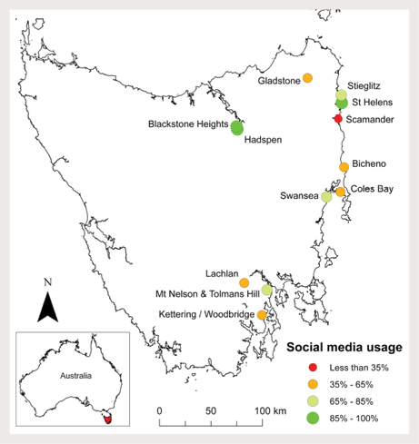
A research questionnaire was developed and administered in 12 at-risk communities across Tasmania (Figure 1). These communities represent a relatively equal distribution across the main populated fire-risk regions.
Multiple survey distribution methods were adopted to reduce potential response bias associated with survey format (e.g. paper-based versus online) and varying lifestyle and work patterns. The lead researcher opportunistically interviewed individuals at each study community. An open access version of the survey was available online and was promoted to communities through sharing on the official TFS Facebook page, local radio, and flyers placed on community noticeboards. In addition, questionnaires were mailed to all residential addresses (n=1075) in four targeted communities spread across each region of the state. A total of 154 complete survey responses were received and collated and analysed in Microsoft Excel and Esri software ArcGIS 10.2, with results standardised using Australian Bureau of Statistics (ABS) 2011 Census data.
The age distribution was uneven with approximately half of the respondents aged 51 or older (Table 1). Comparison with the ABS Census demographic profile confirms the survey dataset was broadly representative of the study communities (Table 1). Each age group was evenly represented except for a slight under-representation of the 18-25 group. An equal proportion of male (n=73) and female (n=77) respondents was recorded (‘other’=2, ‘did not state’=2). The majority of respondents had lived in the area and current house for more than five years.
Table 1. Sample size of each age group as a proportion of the total population of the surveyed communities based on ABS 2011 Census data.
| Age | Sample Size | Total Population | Proportion (%) |
|---|---|---|---|
| 18–24 | 6 | 1 003 | 0.60 |
| 25–34 | 15 | 1 300 | 1.15 |
| 35–50 | 46 | 3 318 | 1.39 |
| 51–70 | 66 | 4 539 | 1.45 |
| 71+ | 21 | 1 485 | 1.41 |
| Sum | 154 | 11 771 |
Awareness of bushfire risk was high with almost all respondents (96 per cent) recognising they live in a bushfire-risk area, 59 per cent of respondents identifying themselves as vulnerable to bushfires. When asked if they felt responsible for preparing for bushfires, 88 per cent of respondents said yes. When proposed that it was the responsibility of local, state and/or federal agencies to prepare for bushfires, 78 per cent agreed. While 70 per cent of respondents considered themselves to be well informed about bushfire and bushfire risk and 74 per cent of respondents were familiar with the Tasmania Fire Service Bushfire Survival Plan, just 59 per cent confirmed they had a bushfire plan. Most respondents (69 per cent) had never attended a bushfire awareness event and only 37 per cent of total respondents said they intend to become more prepared in the next two years (48 per cent said ‘possibly’).
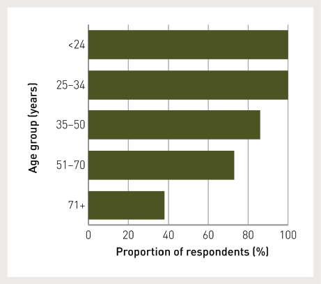
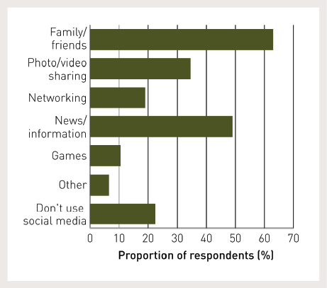
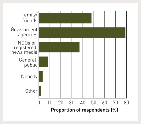
Social media uptake within the study communities was high with 76 per cent of respondents using some form of social media. Social media usage varied spatially with higher rates in more populated areas (Figure 1). There was a decreasing trend in social media use as age increased (Figure 2). The platform most widely accessed among respondents was Facebook (82 per cent), followed by YouTube (53 per cent), LinkedIn (26 per cent), Twitter and Instagram (15 per cent each). Other platforms were reported but not in significant numbers. The main reasons respondents used social media (Figure 3) were to communicate with family and friends and for news and information. Of those who use social media, 51 per cent contribute their own content online and 60 per cent access social media at least once a day. The level of trust given to different online information sources varied with greatest trust given to government agencies (Figure 4).
The potential role of VGI and associated technologies, including social media, for bushfire preparation was well recognised. In this survey, 75 per cent of respondents agreed these technologies can assist to improve preparation, and 74 per cent believed they allow authorities to use local information provided by community members. But at present just 48 per cent of respondents said they would like to share and receive relevant information for bushfire preparation via social media.
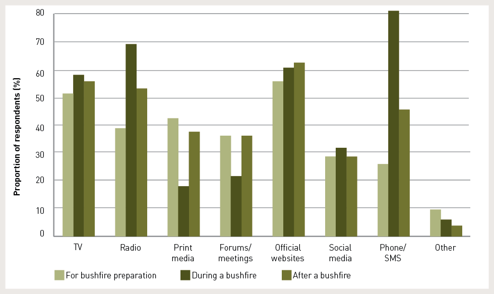
Communication between community members and authorities was identified as important by 97 per cent of respondents. The results presented in Figure 5 show distinct differences in preferred communication methods before, during and after a bushfire.
There is a need for new approaches to engage citizens in risk reduction as shown in this evidentiary analysis. Emerging technologies that allow dynamic and interactive exchange of information may contribute to alternative engagement methods. However, the survey results highlight limitations in the use of these technologies in bushfire management from recognised issues such as the ‘digital divide’ to more nuanced concerns that should be considered in any initiatives to promote adoption of these technologies.
The awareness by respondents of bushfire risk did not necessarily translate to levels of preparedness or intentions to prepare (for similar findings see Whittaker et al. 2013, Eriksen & Gill 2010). Akin to the notion of shared responsibility (McLennan & Handmer 2012), respondents identified themselves as responsible for their own bushfire preparation alongside authorities. Although many respondents stated there was a bushfire risk where they lived and felt vulnerable, fewer respondents had a bushfire plan or intended to become more prepared in the future. Frandsen, Paton and Sakariassen (2011) argue that the goal of facilitating household and community bushfire preparedness cannot be achieved simply by making information on risks and hazards available to people. Sustained hazard preparation is a function of how people interpret information in social and community contexts (Frandsen, Paton & Sakariassen 2011). Thus, novel approaches for communicating bushfire preparedness information are needed; but not only information communication from agency to citizen, but from citizen to agency and between citizens. Approaches that augment traditional processes of information dissemination and reception and facilitate collective, two-way and integrated systems of sharing local and authoritative knowledge may create a wider understanding. They may also increase connectedness and achieve greater participation in risk reduction activities that ultimately increases disaster resilience.
A large portion of the surveyed community used VGI technologies. This use is not limited to reading online content but involves people contributing their own data and information on a daily basis. Many already have the skills, motivation and physical access to the technology required to use social media platforms for various tasks, including communicating with family and friends, information acquisition and sharing photos and videos (Figure 3). Respondents also recognised the potential for new tasks that use the same skillset, such as sharing local knowledge and concerns relating to bushfire preparedness with community members. This presents a potential new ‘virtual landscape’ for preparedness engagement, facilitating both maintenance of existing community ties and the building of new ones. By making users feel connected to a community and increasing their knowledge of other members, social media sites can foster norms of reciprocity and trust and, therefore, produce opportunities for collective action (Valenzuela, Parker & Kee 2009).
The potential use of VGI is also evident in the level of community interest. Most respondents felt social media could assist in bushfire preparation. However, less than half actually like to contribute and receive relevant preparation information with their community through social media. This disconnect between perceived relevance and intent to directly engage is unclear and suggests limitations to the use of VGI technologies and requires further research.
The survey data highlights important challenges to the use of VGI methods in bushfire preparation. The trend of decreasing social media use with increasing age (Figure 2) observed in this study is consistent across the general Australian population (see Socialbakers 2014). The use of these technologies may therefore not be applicable to all members of the community at this time and it is inappropriate to adopt a blanket approach for bushfire management across Tasmania. Research in other fields shows that strategies that use a broad-scale approach to address diverse issues and fail to account for local variation can result in ineffective management (e.g. Haworth, Bruce & Iveson 2013).
Technological factors may also limit VGI approaches resulting in further inequalities associated with remoteness. Spatial variation in the current uptake of social media (Figure 1) may reflect technology access in particular areas (poor internet and mobile phone coverage), or other factors, such as varying life situations. Communities with higher rates of social media usage tend to be in areas of higher population density (such as Launceston, St Helens and Hobart). This may reflect age distribution with higher concentrations of younger people engaged in social media living in cities for increased employment and education opportunities and higher concentrations of retirees in smaller rural towns.
Concern relating to the trust and credibility of online information was an important study finding. While communication with family and friends was most frequently given as a main reason for social media use (Figure 3), less than half of the respondents reported family and friends as a trustworthy information source on social media (Figure 4). Government agencies were cited as trustworthy by most respondents. This is an encouraging result for agencies seeking to incorporate online technologies into their management strategies. But low levels of trust of information sourced from the public may prevent some community members using VGI.
Understanding preferences in communication methods and how they differ at different stages of disaster management (Figure 5) could have important implications for the success of management strategies using a combination of communication tools. The results of this study concur with a recent study by Taylor and colleagues (2012) on community response during Tropical Cyclone Yasi in which respondents preferred to use a range of communication channels, including Facebook, TV news, online news and local radio when seeking information. It is evident that although social media is popular in the community there is still a strong desire for emergency communication via traditional media. The current study showed that although social media is not the most preferred communication medium in any stage of management, those who do prefer social media are consistent in this preference before, during, and after a bushfire event.
Common survey method challenges need to be recognised. Possible biases may be introduced during in-person surveys if respondents alter their responses based on what they perceive to be more socially desirable (Krosnick 1999, Fisher 1993). Question interpretation may influence survey responses (Smith 1987). Both these phenomena are relevant to questions relating to the bushfire plan, for example, resulting in higher reporting of respondents with a comprehensive plan than may actually be the case. Future studies would benefit from placing greater emphasis on explaining key terms or employing methods of data collection that increase opportunity for clarifications. While the mail-out survey distribution method yielded a higher response rate, substantial value was gained from opportunistic, in-person interviews that facilitated informative discussion and the opportunity to manage question misinterpretation.
Significantly, this study provides evidence for the potential use of VGI based on perceived need, uptake of technologies and community interest, but it does not address how this potential could be realised. To offer a possible example, VGI contributed by local individuals to a dynamic community map could identify areas of importance or concern, such as community assets, vulnerable people or areas, ‘safer’ places for evacuation, or high vegetation fuel load areas. This would provide community members with information about their surrounds and assist in planning for bushfire response. Further, spatial awareness of the activities of others may encourage individuals to mobilise and co-operate on preparation tasks that meet mutual needs. Future research should extend this work with more detailed, localised studies to examine how the potential of VGI initiatives highlighted in this paper can be effectively realised.
Results of the community survey demonstrate potential for VGI and associated technologies to be useful in fostering bushfire preparation, but approaches using VGI should not replace traditional methods of bushfire communication and engagement. With increasing access to and familiarity of social media and VGI in communities, it is timely to understand how they can act as a complimentary mechanism for increasing preparedness. The efficacy of these enabling technologies to facilitate greater community awareness, connectedness and collaborative action needs to be evaluated.
Funding and support for this research was provided by the Tasmania Fire Service. It was also supported by the Commonwealth of Australia through the Bushfire and Natural Hazards Cooperative Research Centre. Authors would like to thank the survey participants for providing valuable responses, and Dr Joshua Whittaker and peer reviewers for providing useful feedback on earlier versions of this paper. University of Sydney HREC Approval No. 2013/1069.
Department of Premier and Cabinet (DPAC) 2013, 2013 Tasmanian Bushfires Inquiry Report. At: www.dpac.tas.gov.au/divisions/osem/2013_tasmanian_bushfires_inquiry_report/2013_tasmanian_bushfires_inquiry_report [1 November 2014].
Elwood S, Goodchild MF & Sui D 2012, Researching Volunteered Geographic Information: Spatial Data, Geographic Research, and New Social Practice, Annals of the Association of American Geographers, vol. 102, no.3, pp. 571-590.
Eriksen C & Gill N 2010, Bushfire and everyday life: exploring the awareness-action ‘gap’ in changing rural landscapes, Geoforum, vol. 41, pp. 814–825.
Fisher RJ 1993, Social desirability bias and the validity of indirect questioning, Journal of Consumer Research, vol. 20, pp. 303-315.
Flanagin A & Metzger M 2008, The credibility of volunteered geographic information, GeoJournal, vol. 72, pp. 137-148.
Frandsen M, Paton D & Sakariassen K 2011, Fostering community bushfire preparedness through engagement and empowerment, Australian Journal of Emergency Management, vol. 26, no. 2, pp. 23-30.
Frandsen M 2012, Promoting community bushfire preparedness: Bridging the theory–practice divide (Doctoral dissertation, University of Tasmania). At: http://eprints.utas.edu.au/15309/ [1 November 2014].
Goodchild MF 2007, Citizens as sensors: the world of volunteered geography, GeoJournal, vol. 69, no.4, pp. 211–221.
Haworth B & Bruce E 2015, A review of volunteered geographic information for disaster management, Geography Compass, vol. 9, no.5, pp. 237-250.
Haworth B, Bruce E & Iveson K 2013, Spatio-temporal analysis of graffiti occurrence in an inner-city urban environment, Applied Geography, vol. 38, pp. 53-63.
Intergovernmental Panel on Climate Change (IPCC) 2012, Managing the risks of extreme events and disasters to advance climate change adaptation, In Field CB, Barros V, Stocker TF, Qin D, Dokken DJ, Ebi KL, Mastrandrea MD, Mach KJ, Plattner G-K, Allen SK, Tignor M & Midgley PM (eds), A Special Report of Working Groups I and II of the Intergovernmental Panel on Climate Change, Cambridge University Press, Cambridge and New York.
Krosnick JA 1999, Maximising measurement quality: principles of good questionnaire design, In Robinson JP, Shaver PR & Wrightsman LS (eds), Measures of Political Attitudes, Academic Press, New York.
McLennan B & Handmer J 2012, Reframing responsibility-sharing for bushfire risk management in Australia after Black Saturday, Environmental Hazards, vol. 11, no.1, pp. 1-15.
Paton D 2003, Disaster Preparedness: A social-cognitive perspective, Disaster Prevention and Management, vol. 12, pp. 210–216.
Prober S, O’Connor M & Walsh F 2011, Australian Aboriginal people’s seasonal knowledge: a potential basis for shared understanding in environmental management. Ecology and Society, vol. 16, no.2, pp. 12-27.
Smith T 1987, That which we call welfare by any other name would smell sweeter. An analysis of the impact of question wording on response patterns, Public Opinion Quarterly, vol. 51, pp. 75-83.
Socialbakers 2014, Australia Facebook statistics. At: www.socialbakers.com/facebook-statistics/Australia [21 May 2014].
Taylor M, Wells G, Howell G & Raphael B 2012, The role of Social media as psychological first aid as a support to community resilience building, A Facebook case study from ‘Cyclone Yasi Update’, Australian Journal of Emergency Management, vol. 27, no.1, pp. 20-26.
Tran P, Shaw R, Chantry G & Norton J 2009, GIS and local knowledge in disaster management: a case study of flood risk mapping in Vietnam. Disasters, vol. 33, no.1, pp. 152-169.
Valenzuela S, Park N & Kee K 2009, Is there social capital in a Social Network Site?: Facebook use and college students’ life satisfaction, trust, and participation, Journal of Computer-Mediated Communication, vol. 14, no. 4, pp. 875-901.
Victorian Bushfires Royal Commission (VBRC) 2009, Emergency Management Australia Disasters Database - Major Bushfires in Southern Australia: Hobart and Region, Tasmania: Bushfires. At: www.royalcommission.vic.gov.au/getdoc/a0840c4d-9afa-461b-884f-fbfb0c008b06/RSCH.030.001.0122.pdf [1 November 2014].
Whittaker J, Haynes K, Handmer J & McLennan J 2013, Community safety during the 2009 Australian ‘Black Saturday’ bushfires: an analysis of household preparedness and response, International Journal of Wildland Fire, vol. 22, no.6, pp. 841-849.
Billy Haworth is a PhD candidate in the School of Geosciences, University of Sydney. His primary research interests include GIS and spatio-temporal analysis technologies, volunteered geographic information, citizen science, and natural disaster management.
Eleanor Bruce is a Senior Lecturer in the School of Geosciences, University of Sydney. Her research examines processes of habitat loss in coastal environments, the use of GIS and remote sensing in vegetation change detection, marine zone planning, and the use of geographic citizen science in coastal management.
Peter Middleton is the Community Development Coordinator at the Tasmania Fire Service and facilitator of the Bushfire Ready Neighbourhoods program.