This paper reports the results of research into the design and planning controls of nine international planning jurisdictions dealing with bushfire or wildfire threats. The research sets out fundamental principles to guide the design of settlements at the site and subdivision level with the aim of improving the ability of land-use planning to deliver resilience outcomes in bushfire-prone areas. The analysis and categorisation of design elements internationally was supported by interviews with Australian bushfire experts. The research concludes that there are nine fundamental land-use principles guiding the design of settlements at risk of bushfire impacts.
Bushfires, also known as wildfires, can present significant risks to life and property at the interfaces between urban and rural areas. However, the risks and consequences of bushfire hazards can often be reduced or avoided if appropriate measures are set in place to improve the resilience of buildings and communities. An important way of improving resilience in these urban-bushland and urban-rural interface areas is the initial design of buildings, roads, gardens and other features in ways that reduce bushfire risks.
The research was carried out using a qualitative approach via grounded theory method. Two sources of data were examined. Firstly, nine cases of international policy and guidelines and documentary information from the USA (four cases), France (two cases), Spain (two cases) and Australia (one case) were examined (see Table 1). These cases were chosen based on the quality of detail and evidence base, availability of information to the researchers, the jurisdiction’s potential bushfire severity being high or extreme, and the language knowledge of the authors. Secondly, semi-structured face-to-face interviews with five Australian key professionals and scientists in the bushfire field were conducted to verify the results.
Table 1. International policies and guidelines used in the study.
Country |
Administrative Division |
Year of Publishing |
Name of the Policy |
|---|---|---|---|
USA |
Federal |
2012 |
Codes and Standards, NFPA 1141, Standard for Fire Protection Infrastructure for Land Development in Wildland, Rural, and Suburban Areas. |
2012 |
NFPA 1142, Standard on Water Supplies for Suburban and Rural Fire Fighting. |
||
2013 |
NFPA 1144, Standard for Reducing Structure Ignition Hazards from Wildland Fire. |
||
2014* |
NFPA 1143, Standard for Wildland Fire Management. |
||
California State |
2013 |
California Code of Regulations. Title 14- Division 1.5- Chapter 7- Subchapters 2 and 3 |
|
1943 |
California Government Code. Title 5, Division 1, Chapter 6.8. Very High Fire Hazard Severity Zones, Section 51175-51189 |
||
1939 |
California Public Resource Code. Division 4. , Part 2, Chapter 3. Mountainous, Forest, Bush and Grass Covered Lands 4291- 4299 |
||
San Diego County |
2011 |
General Plan - Chapter Seven, Safety Element. |
|
Orange County |
2005 |
General Plan |
|
FRANCE |
Commune d’Assas |
2005 |
Plan de Prévention des Risques Naturels Prévisibles d’Incendies de Foret (PPRif) |
Commune de la Gaude |
2011 |
Plan de Prévention des Risques Naturels Prévisibles d’Incendies de Foret (PPRif) |
|
SPAIN |
Comunidad Autónoma de Extremadura |
2006 |
Plan de Prevención de Incendios Forestales de la Comunidad Autónoma de Extremadura (Plan PREIFEX) |
Comunidad Autónoma de Galicia |
2006 |
Decreto 105/2006, do 22 de xuño, polo que se regulan medidas relativas á prevención de incendios forestais, á protección dos asentamentos no medio rural e á regulación de aproveitamentos e repoboacións forestais. |
|
2007 |
Lei 3/2007, do 9 de abril, de prevención e defensa contra os incendios forestais de Galicia. |
||
AUSTRALIA |
Victoria State |
2013 |
Victoria Planning Provisions, clause 52.47 |
*Note 2014, referenced as reported, pre-released copy.
By categorising the design intent and mechanisms of the land-use and design controls in the data analysed, this research establishes nine fundamental design principles that guide the design of settlements at the site and subdivision level. This provides an understanding of the range of issues relating to design that can deliver resilience in settlements in bushfire prone environments.
Current international trends show that more disasters occur each year, that their economic impact is higher, and that more people are affected by them (Coppola 2011, p. 18). In Australia, recent analysis has confirmed that climate change effects will lead to significant increases in the incidence of bushfires, and that this will put significant pressure on the ability to manage negative impacts over time as more people seek out rural and natural living environments (Hughes & Steffen 2013, pp. 43-49). However, if managed properly, natural hazards such as bushfires do not necessarily have to become disasters. In fact, all disasters, when systems are overwhelmed with catastrophic effects, are essentially human–made in some sense. Being able to establish clear pathways to deal with the threat of natural hazards so that they do not result in disasters — often understood under the broad umbrella term of resilience — is now a core part of the challenges of urban planning.
An important part of urban planning design is a process of solving problems (within a particular context where actions are needed to improve them (Lawson 1990, Lawson 2004)) through to analysis, synthesis and evaluation. Design facilitated by land-use planning requirements can provide a consistent and logical basis to positively influence design outcomes (Blessing & Chakrabarti 2009, p. 87). For instance, it has been shown that property losses are closely linked with proximity to vegetation, but that, over time, this has not been acted on systematically in Australia (Crompton et al. 2010). Within the 700 metres or so from the urban boundary in which fires typically have impacts
(Chen & McAneney 2004), considerable work is required to improve the characteristics of urban areas to reduce bushfire impacts via design that improves the resilience of settlements and improves opportunities for active interventions during the response phase.
By incorporating disaster management considerations, land-use planning has the capacity to guide the design of settlements to reduce disaster risks, while still allowing some growth in medium risk areas (Burby 1998, pp. 9-10). Further, land-use planning processes can be particularly effective in supporting disaster management. For example, the preparation of land-use plans by local governments ideally includes gathering and analysing data to determine the suitability of land for development (Burby 1998, pp. 1-2, 18), which can include risk assessments (Deyle et al. 1998, p. 160). Moreover, the planning of urban development can include monitoring (Hopkins 2001, p. 16) that can integrate disaster risks and community engagement.
Urban planning can act as a regulatory framework for settlement design, significantly contributing to bushfire risk reduction. While each disaster is to some extent unique, it nonetheless is generally comprised of elements that have a basis in previous events (Alexander 2009, p. 163). Bushfires are no exception. Although bushfires take place in a diversity of contexts and fire regimes (National Wildfire Coordinating Group 2006, p. 75), they behave according to known scientific principles (Ramsay & Rudolph 2003, p. 12). Understanding the main mechanisms of fire behaviour and progression allows fundamental elements to be identified that will lead to improved design of sites and subdivisions at risk of bushfire.
Based on the research, nine planning principles can be identified from international contexts for the guidance of buildings and settlement design in bushfire prone areas. In this paper, the principles are organised under two categories: reducing vulnerability and co-ordinating and improving response (see Table2). The convergence of themes across the different international contexts suggests the value of the principles for developing and testing land-use policies for other places. This applied and place-based approach provides clear pathways to applied resilience via urban planning, adapted to the context of each site.
Table 2. Summary of the nine design principles identified.
Reducing vulnerability |
Co-ordinating and improving response |
|---|---|
|
1) Consideration of the overall context and landscape impacts on exposure from overall fire likely behaviour. 2) Determination of adequate separation from heat and flame sources, given topography, vegetation, likely weather and any other relevant factors. 3) Management or modification of vegetation, landscaping or other fuel sources such as outbuildings. 4) Management of the density, location and design of structures, including reducing vulnerability to ember attack, and integration of building and planning standards appropriate to context and siting. 5) Protection of infrastructure, and care for land uses with greater vulnerability e.g. kindergardens. |
1) Consideration of the availability, capacity, location and travel times of emergency services, if available. 2) Facilitation of the efficient access and egress of emergency services, including integration of separation spaces as spaces for active defence or evacuation locations. 3) Ensure water availability for firefighting, including appropriate location, supply, connectivity and signage. 4) Deal with civilian response actions, including the range of possible actions such as finding refuge, actively defending, or evacuating properties. |
Internationally, five planning principles can be identified in the guidance of the design of sites and subdivisions to reduce vulnerability, based in the first instance on physical mitigation measures. These considerations can improve the mechanisms of interaction between fire as a natural process that takes place in a range of vegetated areas, and the physical structures that support the well-being of humans. Figure 1 summarises these principles diagrammatically.
Figure 1: Reducing bushfire vulnerability.
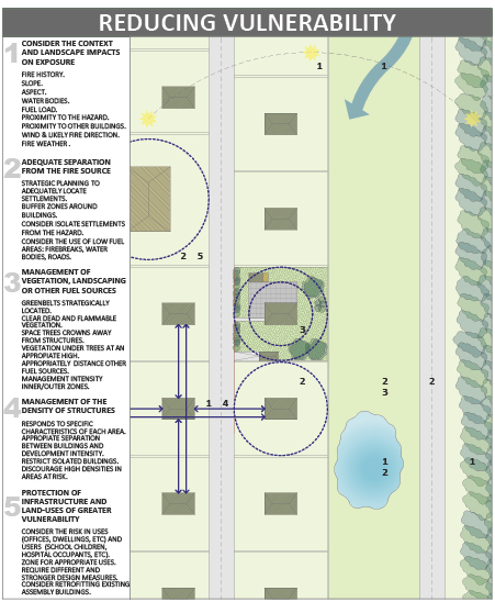
(Source: The authors)
The first planning principle observed across almost all of the cases studied is consideration of context and landscape impacts on exposure as a critical foundation to informing design responses to the nature of fire threats for each context. In order to develop bushfire resilience, urban planning and design outcomes must be directly responsive to the nature of the risks at each site. The codes studied demonstrate establishment of different design requirements according to the range of different possible risk levels and types, by integrating spatial risk assessments within land-use planning processes. These require that the features affecting possible fire behaviour for a given area to be assessed should include aspect, topography, fuel load and proximity to forest/vegetation, water bodies, wind, fire weather, and likely direction and intensity of the fire front. For example, very high fire hazard severity zones are identified in the California Code of Regulations (2006, section 51178):
‘Based on fuel loading, slope, fire weather, and other relevant factors including areas where [….] winds have been identified […] as a major cause of wildfire spread.’
Ideally, the initial design response would have determined the highest likely fuel loading that is possible in the landscape (given that some forests take decades to reach a ‘steady state’) as the basis for the design response. This would preclude the need to subsequently re-assess each year on a site-by-site basis, considering the season’s severity, the area’s fire history and any changes to vegetation over time, to forecast the exposure for each summer. However, since sites often include structures developed prior to bushfire design standards, or ongoing modifications to vegetation, this monitoring may often be necessary as a remedial measure.
Secondly, the determination of adequate separation from the fire source is a fundamental measure for reducing bushfire exposure and, hence, vulnerability. This is required by all codes studied in some way. Separation from ambient heat and direct flame contact can be delivered through the provision of setbacks between buildings or settlements, and the particular fire threats associated with each context. New developments can be required to provide low fuel spaces, such as firebreaks, roads, or managed low-fuel gardens, increasing overall separation from fire hazards. For example, the Comunidad Autonoma de Extremadura (2006 p. 8058) requires 50 metre-wide firebreaks between peri-urban and rural areas, and between urban and peri-urban areas. At the scale of individual sites, buffer zones around buildings can deliver the appropriate separation. For example, a 50 metre buffer zone is required by Comunidad Autonoma de Galicia (2006 p. 10.471). At the subdivision scale, planning and design has real capacity to achieve separation in contrast to small individual sites where possibilities may be constrained by existing lot patterns. This situation implies that existing lots or settlements can be constrained in their ability to provide appropriate separation. Therefore retrofitting measures that modify fuel levels or improve the resistance ratings of individual structures themselves might be appropriate. It also implies that the role of planning at the strategic level is critical to the correct location of new settlements that can achieve these requirements, maintaining that when the risks are too great in some area, no development occurs. Even so, the strategic direction of development may be affected by political and economic interests and pressures separate to resilience concerns.
The third principle is management or modification of vegetation, landscaping or other fuel sources close to settlements and buildings. This principle works in parallel with hazard separation and is one of the most common methods for reducing bushfire risks in the planning codes studied. Nevertheless, it raises significant issues in relation to the appropriateness of human interventions into natural systems, especially the imposition of artificial fire regimes, the removal of natural vegetation, or introduction of non-native species. Considerations include clearance of flammable or dead vegetation, particularly around structures and under trees (National Fire Protection Association 2013 p. 10, County of San Diego 2011, p. 8), adequate separation from other fuel sources, such as wood piles or combustibles (Commune d’Assas 2005 p. 8, 15, Commune de la Gaude 2011 pp. 22-23), and the use of greenbelts (California Code of Regulations 2006, section 1276). Landscape design including the selection of appropriate species can also play an important role. Fuel management can occur on a sliding scale of intensity in relation to the proximity to structures, acknowledging that it is crucial that measures are appropriately maintained over time, and that vegetation may take many years to reach a ‘steady state’. Additionally, there might be social or economic constraints to vegetation management, for example people’s desire to live surrounded by nature, or problems with smoke taint to grapes resulting from fuel reduction burning. Overall, it is more appropriate to manage vegetation at the subdivision scale, a more powerful way of ‘designing out’ underlying bushfire risk via land-use planning. Successful resolution of this principle would represent integration with natural and human processes.
The fourth principle is the management of the density, location and type of structures, which can reduce the likelihood and the impacts of bushfire attack by establishing and integrating the appropriate density of structures and their ability to withstand fire attack according to the specific characteristics of each context. On the one hand, isolated buildings should be restricted where exposure is too high. In the French cases, a minimum separation and prohibition of isolated buildings in peri-urban and rural areas at risk is established (Commune d’Assas 2005, p. 6, Commune de la Gaude 2011, p. 17). On the other hand, in some circumstances higher population densities in exposed areas are discouraged in order to limit population numbers at risk and to avoid building-to-building fire spread. For example, the USA cases studied require that population density minimise the numbers of people exposed to bushfire (County of San Diego 2011, p. 4, Orange County 2005, p. V-75). Nevertheless, it has been demonstrated that larger settlements with clearly defined and well managed edges are generally better at resisting fire penetration. The Australian case that was studied demonstrates integration between the building and planning codes being able to stipulate, on a sliding scale, the ability to withstand heat, flame and ember attack, and the particular characteristics of sites and subdivisions. This means that design outcomes could, within limits, be flexible in many cases, allowing trade-offs between the design standard required of a structure and separation distances or other landscape factors.
Finally, given that certain groups of people or individuals are more susceptible to the consequences of fire events, the protection of infrastructure and land uses of greater vulnerability is another important land-use planning concern for bushfire-prone areas. A common method of managing social vulnerability observed in the codes studied was to zone or regulate land-use to appropriately reflect the risks associated with a given site. For example, high numbers of vulnerable people, such as school children, the infirm or elderly, would be restricted in high risk areas, particularly if evacuation needs exacerbated these risks (County of San Diego 2011, p. 4, Commune de la Gaude 2011). Additionally, the design performance associated with these more vulnerable land uses can require achievement of higher building standards, improving physical resistance (Victoria Planning Provisions 2013, California Public Resource Code 1939, as amended).
An additional four principles that improve active response can be identified in the codes studied. These act as a set of structural measures for the design guidance of sites and subdivisions to reduce vulnerability to bushfires, based on improving the ability to actively defend properties or to evacuate. Land-use planning, through these principles, can increase resilience by facilitating and co-ordinating improved emergency response actions of emergency services and civilians immediately before, during or immediately after potential disasters. Figure 2 shows the main themes associated with co-ordinating and improving bushfire response.
Figure 2: Co-ordinating and improving bushfire response.
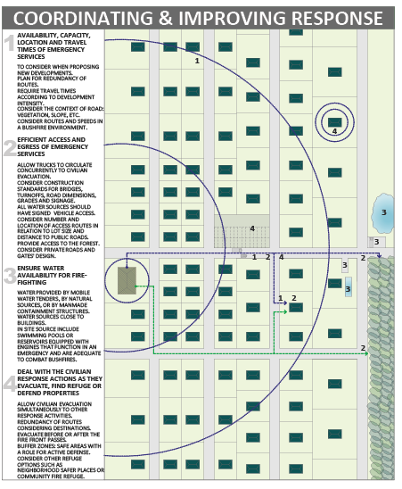
(Source: The authors)
The first principle observed in most of the codes studied is consideration of the availability, capacity, location and travel times of emergency services. This recognises the link between the ability of land-use planning policy to influence the location and layout of settlements, and the ability of emergency crews to respond effectively. However, it was also recognised in many of the policies that this may not be reliable as a viable tactic in many locations due to particular terrain, street layouts or isolation. Response assessments were required in the design phase to integrate several non-planning considerations such as resources, location, dispatch, and expected travel times. Traffic management was required to plan for route redundancy in the case of traffic networks being overwhelmed, for instance, by smoke, road blockages, or other fire effects. In the Victorian context, citizens cannot expect emergency services to attend every site during an emergency. This is a reflection of resources realities and learning since Black Saturday in 2009. Due to the extensive scale of bushfire disasters, emergency services need to prioritise their response actions, suggesting that resilience, in many cases, relies on increasing community responsibility to actively respond to events, based on appropriate design principles underlying the settlement being defended.
Secondly, assuming agency response can take place, facilitation of the efficient access and egress of emergency services is one of the most important and common design measures that land-use planning and design offers to redress residual vulnerability. This may include technical requirements to ensure that fire appliances can circulate in ways that allow active defence, in some cases allowing the access of response agencies and the evacuation of residents concurrently (California Code of Regulations 2006, Section 1273, County of San Diego 2011, p. 8). In addition, opportunities that allow emergency services to access fire edges in active firefighting processes must be provided (Commune d’Assas 2005, p. 9). At the site scale, private roads and gate design, location and number of access routes according to the size of each lot, and distance to public roads is also important (Commune d’Assas 2005, p. 7, National Fire Protection Association 2012, pp. 7-10). The design of sites must also consider the ability for firefighters to circulate, for instance, clearing vegetation along roads.
The third principle is to ensure water availability for firefighting purposes by residents and responding agencies. This is a fundamental and frequent design consideration observed in the study of land-use regulation in bushfire-prone areas. Technical requirements are generally defined based on risk levels. At the subdivision scale, water supply for suppression activities typically takes into account the availability and quantity of water delivered by mobile water tenders, by human-made containment structures, or by natural sources (California Code of Regulations 2006, Section 1275). Also the visibility of water supply points, appropriately signed (California Code of Regulations 2006, Section 1275), and their accessibility allowing vehicle access (Comunidad Autonoma de Extremadura 2006, p. 8092) are important. At the individual site scale, water sources, such as swimming pools or reservoirs equipped with engines that can function in a bushfire scenario (Commune d’Assas 2005, p. 15) without depending on electricity supplies, need to be appropriate for bushfire suppression (County of San Diego 2011, p. 9), be sited near buildings (Commune de la Gaude 2011) and be sufficient to last throughout the event. Additionally, many planning provisions allowed for response mechanisms to include automated fire protection or suppression systems such as sprinklers. Nonetheless, passive measures were prioritised over active ones, which can be less reliable since they may require power and need to be strictly maintained to ensure operation under duress.
The final principle in land-use planning resilience is to deal with civilian response actions as they evacuate, find refuge or defend properties. Facilitating evacuation (if appropriate) and ensuring defensible space can have many and often inter-related dimensions, also affected by other regulations. For example, Australia’s ongoing policy has been to ‘leave early, or prepare, stay and defend’, which strongly discourages late evacuation. While controversial, overall, the policy appears to be appropriate except in extreme cases, but implies that resilience requires significant preparation, information, and social learning—additional to and beyond the scope of planning regulations. In many fires, active defence by appropriately equipped, physically fit and mentally prepared civilians will prevent small fires escalating to destroy buildings. Importantly, at the individual site level, if persons have decided to stay and defend, or have been surprised by events, the design and maintenance of a building will significantly aid the use of a house as a place of refuge while a fire passes. Additionally, if separation from fuel sources and fuel management are integrated into the design of a structure on its site (as specified above), even if a house does catch fire, the managed low fuel area (such as a house’s backyard) will provide a place of refuge for people, because the main fire front is likely to have passed by the time they have to leave the building. This safe area can have a role for active defence, as it can be implied in the ‘defendable space’ concept set by Victoria Planning Provisions (2013) and in the ‘defensible space’ idea established by the California Code of Regulations (2006, section 1271). Nevertheless, since evacuation cannot be relied on as a failsafe mechanism in many situations and the provision of a safe space for active defence is not always possible, it is crucial to consider the provision of other alternatives of refuge, such as neighbourhood safe places or community fire refuges.
Based on examination of a number of leading international examples and verification with leading Australian experts, this paper has summarised nine key principles that ideally would exist as fundamental features of any planning code which seeks to reduce bushfire risks via urban planning and design. Planning approaches can set out fundamental principles for the design of settlements to increase resilience to bushfires. These principles are under two major categories: reducing vulnerability and co-ordinating and improving response. Bushfire resilience depends, to a great extent but not exclusively, on the layouts of settlements being resistant to bushfire effects. The physical design of a settlement can be more bushfire resilient if it reduces human vulnerability through social and physical mechanisms and maximises the ability for active human resistance to bushfire threats, such as firefighting. These design principles can significantly contribute to achieving resilience and design outcomes should respond to the particular nature of the bushfire threat in a given place in order to improve effectiveness. Further, the physical design of settlements can facilitate improved human resistance to threats as another aspect of resilience. This paper has focussed on the level of the site and subdivision, but it is acknowledged that further important work is also required at the strategic level.
Alexander D 2009, Principles of Emergency Planning: Standardisation, Integration and Sustainability. Building Safer Communities. Risk Governance, Spatial Planning & Responses to Natural Hazards, p. 58, pp. 162-174.
Blessing L & Chakrabarti A 2009, DRM, a Design Research Methodology, London, New York, Springer.
Burby RJ 1998, Natural Hazards and Land Use: An Introduction. In: BURBY, R. J. (ed.) Cooperating with Nature. Washington D.C.: Joseph Henry Press.
California Code of Regulations 2006, Title 14- Natural Resources, Division 1.5- Department of Forestry, Chapter 7- Fire Protection, Subchapters 2 and 3. California, USA.
California Public Resource Code 1939, as amended. Division 4. Forest, Forestry and Range and Forage Lands, Part 2. Protection of Forest, Range and Forage Lands, Chapter 3. Mountainous, Forest, Bush and Grass Covered Lands 4291- 4299 California, USA.
Chen K & McAneney J 2004, Quantifying bushfire penetration into urban areas in Australia. Geophysical Research Letters, 31, pp. 1-4.
Commune D’Assas 2005, Plan de Prévention des Risques Naturels Prévisibles d’Incendies de Foret (PPRif). Préfecture de l’Herault, France.
Commune de la Gaude 2011, Plan de Prévention des Risques Naturels Prévisibles d’Incendies de Foret (PPRif). Préfecture des Alpes Maritimes, France.
Comunidad Autonoma de Extremadura 2006, Plan de Prevención de Incendios Forestales de la Comunidad Autónoma de Extremadura (Plan PREIFEX). España.
Comunidad Autonoma de Galicia 2006, Decreto 105/2006, do 22 de xuño, polo que se regulan medidas relativas á prevención de incendios forestais, á protección dos asentamentos no medio rural e á regulación de aproveitamentos e repoboacións forestais: España.
Coppola D 2011, Introduction to International Disaster Management, Amsterdam, Boston, London, New York, Oxford, Paris, San Diego, San Francisco, Singapore, Sydney, Tokio, Elsevier.
County of San Diego 2011, General Plan - Chapter Seven, Safety Element. California, USA.
Crompton R, McAnenery K, Chen K, Pielke RJ & Haynes K 2010, Influence of Location, Population, and Climate on Building Damage and Fatalities due to Australian Bushfire: 1925–2009. 2010 American Meteorological Society, 2, pp. 300-310.
Deyle RE, French SP, Olshansky RB & Paterson RG 1998, Hazard Assessment: The Factual Basis for Planning and Mitigation. In: BURBY, R. J. (ed.) Cooperating with Nature. Whashington D.C.: Joseph Henry Press.
Hopkins LD 2001, Urban Development: The Logic of Making Plans Washington, Covelo, London, Island Press.
Hughes L & Stefen W 2013, Be prepared: climate change and the Australian bushfire threat. Canberra: Climate Council of Australia.
Lawson B 1990, How designers think, London, Boston, Singapore, Sydney, Toronto, Wellington, Butterworth Architecture.
Lawson B 2004, What designers know, Amsterdam, Boston, Hiedelberg, London, New York, Oxford, Paris, San Diego, San Francisco, Singapore, Sydney, Tokyo, Architectural Press.
National Fire Protection Association 2012, Codes and Standards, NFPA 1141, Standard for Fire Protection Infrastructure for Land Development in Wildland, Rural, and Suburban Areas [Online]. At: www.nfpa.org/codes-and-standards/document-information-pages [9 October2013].
National Fire Protection Association 2013, Codes and Standards, NFPA 1144, Standard for Reducing Structure Ignition Hazards from Wildland Fire [Online]. At: www.nfpa.org/codes-and-standards/document-information-pages [9 October 2013].
National Wildfire Coordinating Group 2006, Glossary of Wildland Fire Terminology.
Orange County 2005, General Plan. California, USA.
Ramsay C & Rudolph L 2003, Landscape and Building Design for Bushfire Areas. [electronic resource], Melbourne, CSIRO Publishing.
Victoria Planning Provisions 2013, Particular provisions, clause 52.47 Bushfire Protection: Planning Requirements In: Department of Transport, P. A. L. I. (ed.). Victoria: State Government Victoria.
Constanza Gonzalez-Mathiesen is an Architect and Urban Planner who worked as a researcher in the Faculty of Architecture, Building and Planning before returning to practice in Chile after completing a Master of Urban Planning at the University of Melbourne.
Dr Alan March is Associate Professor in Urban Planning in the Faculty of Architecture, Building and Planning at the University of Melbourne and Associate Dean (Undergraduate). His research includes examination of the practical governance mechanisms of planning and urban design, and the role of urban planning in reducing disaster risks.
Associate Professor Alan March and Susan Henry published a paper titled ‘A better future from imagining the worst: land use planning & training responses to natural disaster’, in the August 2007 AJEM. This paper, freely available online, inspired a Chilean student, Jorge Leon, to research in the field of land use planning and come to Australia to study at the University of Melbourne with Associate Professor March. See page 57 for the full story.

