Uruguayan air force flight 571 was flying from Montevideo, Uruguay to Santiago, Chile when it crashed in the Andes at an altitude of13,800 ft. Amongst the 45 occupants of the aircraft12 died during the crash. The aeronautical searches were stopped after eight days without having found the aircraft. Seventy two days later the world learned that there were some survivors - 2 passengers trekked across the Andes to search for rescue. Amongst the 33 survivors of the crash only16 were still alive by that time.
Forty years have passed since this event. So the question is would the aircraft immediately be found if the same accident happened today or would it take a similar amount of time to locate it?
The subject of this paper is the need for a new tool in the field of the aeronautical search and rescue operations to ensure that emergency management teams can minimise the search time of an aircraft crash location.
This paper first examines the aeronautical search operations starting with a brief overview of the regulations. Based on the past events in the world the different techniques and technologies are explored followed by an analysis of the duration of search operations.
The paper finally exposes why seismology should be taken into consideration by emergency teams to fulfil their commitments towards survivors of an aeronautical event. The principles of seismology are explained and their applications to airport operations are shown through an experiment conducted at Prestwick international airport, in Scotland. Finally, one past event is used to demonstrate the usefulness of seismology.
The signatory states of the “Chicago Convention” must take the necessary steps to ensure that aircraft in an emergency situation can be assisted by search and rescue (SAR) services (International Civil Aviation Organization 2006). To fulfil this commitment, each contracting states under ICAO regulations (International Civil Aviation Organization 2004) defines at least one SAR area within the limits of its territory. Each SAR area needs an adequate number of SAR units equipped with an appropriate number of fixed-wing aircraft and/or helicopters capable to cover the entire surface of the area. Then, an Aeronautical Rescue Coordination Centre (ARCC) is established within each SAR area to initiate and coordinate SAR units.
For example, Australia has set up a National Search and Rescue Council in1999 responsible for the coordination of the Australian SAR operations at the following levels: Commonwealth, State and territory (National Search and Rescue Council 2004). Furthermore, the Australian government has designated the Australian Maritime Safety Authority (AMSA) to be the agency responsible for the provision of the necessary SAR services (Australian Maritime Safety Authority1990) within the entire SAR area that covers Australian mainland, the surrounding Islands, the sectors of the seas surrounding Australia and part of Antarctica (National Search and Rescue Manual 2011). The ARCC, located in Canberra, under the authority of AMSA coordinates and activates the different air units in Australia (National Search and Rescue manual 2011).
When an aircraft fails to report at a compulsory navigation point and radio communication is not maintained, search and rescue operations are initiated. ICAO (2004) has defined three levels of emergency: level one – uncertainty, level two – alert and level three – distress. It is only when the level three is reached that the SAR units are activated. Then, it is the responsibility of the RCC to determine a “possibility area”, usually too large to be searched and further to narrow it to delineate a “probability area” (National Search and Rescue manual 2011). It takes a long time to do so, up to two hours sometimes (Bureau d’Enquêtes et d’Analyses1993).
When a “probability area” is defined SAR helicopters and aircraft start searching for the location of the missing aircraft using different standard aeronautical search patterns jointly recommended by the International Maritime Organisation (IMO) and ICAO (International Maritime Organization and International Civil Aviation Organization 2007). The most commonly used pattern called the track line consists of flying along the missing aircraft track between its last reported position and the position where the next report was due. This technique was used by a USAF C-141 to locate Air New-Zealand missing DC10 in Antarctica in1979, but the wreckage was found only after a twelve hour search (US Navy1979).
Considering that of course each search operation has its own particularities and therefore may require a different amount of time, the previous examples however highlight the point that search operations using traditional methods can be very lengthy – in fact too lengthy for the survivors of an aircraft accident.
In the1970’s the idea of having an emergency beacon on board of each aircraft to shorten the search time for a missing aircraft was proposed. Since, the carriage of an Emergency Locator Transmitter (ELT) by all aircraft is mandatory (International Civil Aviation Organization 2001). This equipment is either manually or automatically activated upon impact. But, do passengers know that this emergency device is on board an aircraft and where it is located and how to use it, certainly not.
The ELT is mainly composed of a remote control in the cockpit, a main unit in the rear top fuselage and an antenna on top of the rear fuselage, all connected by cables. If one of these components is damaged the ELT cannot transmit a signal (Cameroon Civil Aviation Authority 2010). Moreover, even if all the components are not damaged, the antenna may relay an intermittent signal. In 2005, the Nord-Flyg Cessna 208 wreckage was discovered upside down with the ELT antenna pointing towards the ground nearby Helsinki airport runway end, resulting in a weak signal transmission (Accident Investigation Board Finland 2005).
Furthermore, the Emergency Locator Transmitter operates only if a certain amount of G-forces versus the time is recorded (ELTA 2011): a short time impact with a high value of G-forces or a long time impact with a low value of G-forces. In 2009, Gol Transportes Aereos Boeing B737-700 aircraft short time impact and low G-forces were not sufficient to activate the ELT, when it crashed in the Amazonian forest in Brazil (Centro de Investigação e Prevenção de Acidentes Aeronáuticos 2008).
Consequently, it can be said that the Emergency Locator Transmitter has not demonstrated yet that emergency teams can entirely rely on it to reduce the search operations after an aircraft crash.
The Cosmicheskava Sistyema Poiska Avariynich Sudov – Search and Rescue Satellite Aided Tracking (Cospas-Sarsat) satellites system was set up in the early 80s. Each satellite uses its on-board SAR equipment to detect and transmit ELT signals. Ground receiving stations, called Local User Terminal (LUT), transmit distress signals received by SAR satellites to Mission Control Centres (MCC) that process it to ARCC. The constellation of satellites comprises 6 Low Earth Orbit SAR satellites (LEOSAR) in polar orbits and 5 Geostationary SAR satellites (GEOSAR).
LEOSAR satellites do not cover Earth continuously. Instead, they have a field of view of a continent size, around 6,000 kilometres wide. Fifty minutes could be necessary for a distress beacon first to be seen by a satellite, then to have the signal stored on its board before to be downloaded to the nearest LUT. Then, the location of the beacon is made using Doppler techniques (Cospas-Sarsat 2011). More than fifty minutes elapsed between the activation of Nord-Flyg Cessna 208 ELT in Finland and the determination of a wreckage location by the system. But, the aircraft was already found by the search team (Accident Investigation Board Finland 2005).
GEOSAR satellites do not use Doppler techniques to determine the location of a beacon, as they are located above the Equator and on the same Earth position all the time. Instead, the beacon must be equipped with a navigation system, such as the Global Positioning System (GPS). If not, the LEOSAR satellites will need to be used. Also, those satellites cover only the regions located from the Equator up to the 60° Latitude but not up to the higher latitudes (Cospas-Sarsat 2011).
Therefore, anyone can understand that the Cospas-Sarsat is not reliable all the time leaving the SAR teams with no other option that to use the aeronautical search techniques.
Nobody can tell after an aircraft crash how long the search operations will last. The duration depends mainly on the same following factors.
Remote areas still exist all over the planet. Small airports operate airstrips with no radar facilities in these locations. In this case, the latest information concerning an aircraft is not available leading to searches of more than one day ((National Transportation Safety Committee 2009; Department of Transport Accident Investigation Commission 2009).
Airports with no radar facilities can also be located in non-remote areas, leading again to several hours of search (Aeronautica Civil de la Republica de Colombia1996; Spanish Civil Aviation Accident Commission1981).
Radars give the latest known data related to a missing aircraft. But, it takes a long time to extract and to analyse the data, at least 40 minutes or even more (Transport Accident Investigation Commission1997; Bureau d’Enquêtes et d’Analyses1993).
In fact, radar data even if available immediately will only help to delineate a search area (Bureau d’Enquêtes et d’Analyses1993) but will never give the precise location of an aircraft accident.
Aircraft are equipped with an emergency locator transmitter to shorten the finding of their wreckage after an accident. Sometimes the equipment is destroyed or damaged during the occurrence (Bureau d’Enquêtes et d’Analyses1993; Cameroon Civil Aviation Authority 2010).
Also, many aircraft in the world still carry the old generation of ELT using the121.5 MHz frequency. But, since February 2009, the Cospas-Sarsat satellites system no longer processes the distress signals transmitted on that frequency. As a result some aircraft accident locations need at least a day of search before a SAR helicopter or aircraft overflying the area will find the wreckage ((Department of Transport Accident Investigation Commission 2009).
Last, even if the ELT is activated the search area to be covered will be of1260 sq. km for the old beacon generation and of13 sq. km for the new one (Defence Research and Development Canada 2009). The latest is better but it may still take some time to be searched.
Searches at an altitude above 5,000 feet will usually be the longest one, up to several days (National Transportation Safety Committee 2009) as for Merpati Nusantara Airlines missing De Havilland DHC-6 in Papua.
Therefore, it is obvious that the search for an aircraft accident in the mountain would be most of the time longer than one in the lowlands.
Emergency teams encountered snow showers during the12 hours search of Air New Zealand DC10 in Antartica (US Navy1979). Air Inter Airbus A320 in the Vosges Mountain in France (Bureau d’ Enquêtes et d’Analyses1993) and Vnukovo Airlines Tupolev154 in Spitsbergen in Norway (Aircraft Accident Investigation Board Norway1999) wreckages were difficult to find because of the prevailing fog conditions.
Hence, it can be seen from these few examples how meteorology can have a big impact on search operations.
Dense rain forest, swamp are some elements that can lengthen search operations (Centro de Investigação e Prevenção de Acidentes Aeronáuticos 2008; Cameroon Civil Aviation Authority 2010). The search of Air New Zealand DC10 in Antarctica took a long time because the aircraft was on one of Mount Erebus slopes covered by ice. A white painted aircraft on a white ground in a mountain is not easy to find (Transport Accident investigation Commission1980).
Thus, the wreckage location has a great influence on the searches duration.
The different elements that have an influence on the search operations duration have been explained. It can be very well understood why some missing aircraft searches are so lengthy and why a new tool is needed.
Seismology is usually considered as the science that explores both the constitution of the Earth’s interior and the earthquakes. It studies all the vibrations recorded on and in the Earth (Doyle1995, p.1).
Seismographs deployed all over the Planet detect all those vibrations. They are composed of a seismometer to measure the ground motion, of an amplifier to amplify the signals and of a recorder to record all the data (Udías1999, pp. 404-410).
Seismometers are made of pendulums that move vertically or horizontally depending on the motion detected. These movements are conventionally called “Z” for the vertical component and “North-South” and “East-West” for the horizontal component (Bullen & Bolt1985, pp. 201-205).
Seismograms are those documents on which the different components of the seismic waves generated by the ground motions are written.
Seismic waves shown on the seismograms are of three different types: P-waves (Primary waves), S-waves (Secondary waves) both travelling through the internal structure of the Earth and the surface waves. P-waves travel faster than S-waves which in turn travel faster than surface waves. Because they travel faster P-waves arrive first at seismic stations followed respectively by S-waves and surface waves.
P-waves and S-waves average speeds are known. Consequently, the time difference between both waves gives the distance from a seismograph to an event. By triangulation that is by using the records of different seismographs, the location of an event can be determined (Davison1921, p.159).
To answer to the question – can seismic equipment record aircraft crashes? It is first necessary to answer to the following question – can seismographs record an aircraft normal landing at an airport?
For this purpose we conducted an experiment at Prestwick international airport, west of Scotland during a day. The airport is composed of two runways that intersect at right angle at their ends. Three GURALP CMG-6TDs seismographs, loaned by the National Environmental Research Council (NERC) in the UK, were buried at the following positions (Figure1): -seismograph n°1 on the left hand side of runway 03 touchdown marking zone and 90 meters away from the runway centreline, -seismograph n°2 on the right hand side of runway 31 touchdown zone and135 meters away from the runway centreline, -seismograph n°3 on the left hand side of runway13 touchdown zone and123 meters away from the runway centreline.
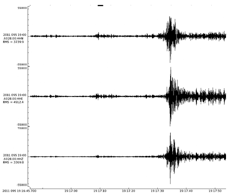
Cargolux Boeing B747-400 landed at19.18’ UTC according to the air traffic control. All the three components of the seismograph n°2 clearly show the aircraft landing around19.17’.35’’ UTC (Figure 2). The runway 31 was in use at that time.
Figure 1. Map of Prestwick airport showing the location of the seismographs.
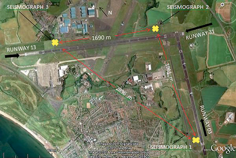
Figure 2. Seismograph n°2, from top to bottom North-South, East-West and Vertical components, filtered to 10.000-15.000 Hz, time in seconds, Y axis in counts (-55000 to 55000), displaying Cargolux Boeing B747-400 landing.
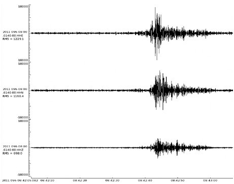
To further illustrate the application of seismology to aircraft normal landings, the records of Ryanair Boeing B737-800 by the seismograph n°3 are used. The touchdown can be seen perfectly around 08.42’45’’ UTC on each component seismogram where on the other hand the air traffic control data gives the official landing time at 08.43’ UTC (Figure 3). The runway13 was in use at that time.
Figure 3. Seismograph n°3, from top to bottom East-West, North-South, and Vertical components, filtered to 10.000-15.000 Hz, time in seconds, Y axis in counts (-18000 to 18000), displaying Ryanair Boeing B737-800 landing.
Knowing that aircraft normal landings could be recorded by a seismograph, the next step was to find an example from a past event.
Vnukovo airlines Tupolev TU-154M crashed into the Operafjellet Mountain near Longyear airport on Svalbard Island in Norway on the 29 August1996. The time of the occurrence was determined by the aircraft investigation board using the seismic data at 08.22’.23’’ (Aircraft Accident Investigation Board Norway1999).
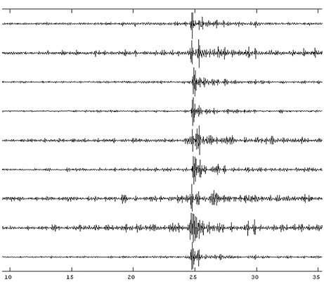
At least nine seismographs have recorded the occurrence. The impact can be seen very clearly around 08.22’.24’’ on each seismograms of the different seismographs vertical components (Figure 8). The investigation report accident time has been corrected by the distance between the event location and the different seismographs.
Figure 4. From top to bottom seismograms of seismographs SPA0, SPA1, SPA2, SPA3, SPB1, SPB2, SPB3, SPB4, SPB5, vertical component, filtered 10.000-15.000 Hz, time in seconds, displaying Vnukovo airlines Tupolev impact.
Despite having set up appropriate search and rescue services that comply with the international regulations, countries in the world cannot ensure that their emergency management teams have the adequate tools in their hands to fulfil their commitment towards survivors of an aeronautical event.
In fact, the traditional search techniques using search and rescue aircraft and helicopters are too lengthy while emergency locator transmitters and the Cospas-Sarsat satellites system are not100% reliable.
Also, while search operations could sometimes be short, different external factors, such as the altitude, the location or the weather can have an important impact and lengthen searches to days.
On the other hand, seismographs not only can record ground motion generated by earthquakes or volcano eruptions but also by a normal aircraft touchdown or by an aircraft crash.
Consequently, the principle of seismology that is the location of an event by triangulation could also be applied towards the location of a missing aircraft.
Therefore, emergency senior management could take into consideration seismology as an additional tool to shorten to its minimum the duration of search operations, thus enhancing the survival probability of aircraft crashes survivors.
A special thanks to my assistant Adah Majala Tole, BEng. in Aeronautical Engineering, University of Glasgow. Alex Brisbourne from SEIS-UK was the first person to accept to loan three seismographs under a “loan pilot” from the UK NERC GEF for this unusual project. Victoria Lane SEIS-UK installed the equipment; her work has been much appreciated. Fiona Longford, Prestwick airport airfield operations manager and Steve Thomson, Prestwick airport engineering manager, gave the authorization to conduct the experiment, dedicated a lot of their time towards its accomplishment and provided all the necessary data and equipment. This experiment would not have been possible without the work of Andy, Prestwick airport operations supervisor, Mathew, Prestwick airport engineering duty manager, and Prestwick airport engineering staff members. Tony Smedley and Ian Scouller, University of Glasgow, have been a great help for the logistics. A great thank to Dr Ottemoller for his help and the Norway data.
Accident Investigation Board Finland 2005, Investigation report B 2/2005 L, Aircraft accident at Helsinki-Vantaa airport on 31 January,2005, Helsinki.
Aeronautica Civil de la Republica de Colombia 1996, Informe sobre el accidente de una aeronave en vuelo controlado hasta caer en tierra, vuelo 965 American Airlines, Boeing 757-223 N651 AA, en las cercanias de Cali Colombia, Diciembre 20,1995, Santafe de Bogota.
Aircraft accident Investigation Board Norway 1999, Report on the accident to Vnukovo Airline’s Tupolev TU-154M RA 85621, near Svalbard airport, Longyear, Norway, on 29 August1996, Oslo.
Australian Maritime Safety Authority Act 1990 (Cwlth), ss.1-7, Office of legislative drafting and publishing, Canberra.
Bullen, KE & Bolt, BA 1985, An introduction to the theory of seismology, Cambridge University Press, Cambridge.
Bureau d’Enquêtes et d’Analyses 1993 Rapport de la commission d’enquête sur l’accident survenu le 20 janvier1992 près du Mont Sainte-Odile (Bas-Rhin) à l’Airbus A320 immatriculé F-GGED exploité par la compagnie Air Inter, Paris.
Cameroon Civil Aviation Authority 2010, Technical investigation into the accident of the B737-800 registration 5Y-KYA operated by Kenya Airways that occurred on the 5th of May 2007 in Douala, Douala.
Centro de Investigação e Prevenção de Acidentes Aeronáuticos 2008, Final report A-00X/CENIPA/2008, Brasilia.
Cospas-Sarsat 2011, LEOSAR system & GEOSAR system, viewed on 3 August 2011, <http://www.cospas-sarsat.org>
Davison, C1921, A manual of seismology, Cambridge University Press, Cambridge.
Defence Research and Development Canada 2009, Emergency locator transmitter (ELT0 performance in Canada from 2003 to 2008: statistics and human factors issues, Toronto.
Department of Transport Accident Investigation Commission, Aircraft accident investigation interim report, collision with terrain, P2-MCB, De Havilland DHC 6-300, 6 NM SSE Kokoda,11 August 2009, Port Moresby.
Doyle, H1995, Seismology, John Wiley & Sons Ltd, Chichester.
ELTA 2011, User’s handbook including installation manual and log book, Emergency locator transmitter, model ADT 406 AP in the Cospas - Sarsat system, Blagnac.
International Civil Aviation Organization 2001, International standards and recommended practices, Annex 6 to the convention on international on international civil aviation, Operation of aircraft, part I, international commercial air transport – aeroplanes, 8th edn, International Civil Aviation Organization, Montreal.
International Civil Aviation Organization 2004, International standards and recommended practices, Annex12 to the convention on international civil aviation, Search and rescue, 8th edn, International Civil Aviation Organization, Montreal.
International Civil Aviation Organization 2006, Convention on international civil aviation, 9th edn, International Civil Aviation Organization, Montreal.
International Maritime Organization & International Civil Aviation Organization 2007, IAMSAR manual, international aeronautical and maritime search and rescue manual, volume II, mission co-ordination, 3rd edn, International Maritime Organization & International Civil Aviation Organization, London & Montreal.
National Search and Rescue Council 2004, Appendix C - Inter-governmental agreement on national search and rescue response arrangements, National Search and Rescue Council, Hobart.
National Search and Rescue Council 2011, National search and rescue manual, National Search and Rescue Council, Canberra.
National Transportation Safety Committee 2009, Aircraft accident investigation report, PT. Merpati Nusantara Airline, De Havilland DHC6 Twin Otter, PK-NVC, near Ambisil, Okbibab, Papua, Republic of Indonesia, 2 August 2009, Jakarta.
Spanish Civil Aviation Accident Commission 1981, Report on the accident to Boeing 727 G-BDAN on Tenerife, Canary Islands, on 25 April1980, London.
Transport Accident Investigation Commission 1980, Air New Zealand McDonnell-Douglas DC10-30 ZK-NZP, Ross Island, Antarctica, 28 November1979, report 79-139, Wellington.
Transport Accident Investigation Commission 1997, Report 95-011, De Havilland DHC-8, ZK-NEY, controlled- flight into terrain, near Palmerston North, 9 June1995, Wellington.
Udías A 1999, Principles of seismology, Cambridge University Press, Cambridge.
US Navy 1979, US Navy SITREP (Situation report) 28 November1979, US Navy, Antarctica.
Nadine Alavès is a graduate of Swinburne University of Technology with a Master of Technology Management (Air Transportation Management) now (Aviation Management).
She is currently a PhD student in Aeronautical Engineering at the University of Glasgow. Her field of research is aeronautical search and rescue operations.

