
The growing incidence of large wildfires over the last decade has revealed the need for more appropriate and effective measures for assessing bushfire risk. For example, during the 2007 and 2009 fire seasons in Greece and California a series of wildfires burned thousands of square kilometres of land causing extensive damage. Thousands of houses were destroyed, critical infrastructure such as major roads and transmission lines were lost, many people were injured or killed and approximately one million people were displaced, with the overall cost of the fires amounting to billions of dollars. The mix of extended drought periods and the increasing number of homes built in canyons and on slopes surrounded by forest and shrubland has only exacerbated the already difficult problem of managing wildfire risk in these areas. Similarly in Australia, vast tracts of land were consumed in extreme bushfires during the 2002/03 and 2006/07 fire seasons, resulting in multiple fatalities and the loss of numerous dwellings and important infrastructure. The fires also devastated ecological, cultural and hydrological assets, with ongoing consequences. The ‘Black Saturday’ fires in Victoria during February 2009 resulted in the destruction of a number of townships and unprecedented loss of life. At the time of writing they stand as the worst natural disaster in Australia’s history.
It is necessary to clarify the term ‘extreme’ used here. Historically in Australia ‘extreme’ has been used for a fire danger rating, corresponding to a fire danger index over 50 until 2009, and redefined after Black Saturday as being between 75 and 100. There is no correlation between extreme fire danger rating and an extreme fire as used in this paper, where the term refers to the fire’s dynamics. An additional point to note, which will be explained below, is that the behaviour of an extreme fire is poorly related to fire danger index.
In the aftermath of these extreme fires there have been a number of inquiries aimed at investigating the potential shortcomings of operational and strategic methodologies surrounding the management of bushfire risk, and devising ways of overcoming them. The Royal Commission into the 2009 Victorian bushfires is one such example. The Royal Commission Interim Report (Teague et al., 2009) covers a wide range of issues arising from the disaster including the causes of the fires, their impact on infrastructure, community awareness and understanding of established bushfire risk management tools and preparation and response measures that follow from them. In examining these issues the Royal Commission produced a list of recommendations aimed at decreasing the susceptibility and improving the resilience of the community to such extreme bushfire events. One group of recommendations concerned the provision of timely and accurate warnings. In particular, Recommendation 4.3 (p144, Teague et al., 2009) calls on the State (of Victoria) to commission research into the development of a new fire severity scale that denotes the risk posed by dangerous and extremely dangerous bushfires. In fact the recommendation alludes to the development of a scale analogous to that defined by the cyclone categories 1 to 5 used in Australia.
There are of course a number of fundamental problems with drawing such an analogy. In the case of cyclones, the categories are determined by well-defined and directly measurable quantities such as average wind speed, maximum wind gust or the central atmospheric pressure. However, in the case of bushfires there does not appear to be any direct analogue of these quantities. The area burned by a fire or its convective power may be suitable measures but neither of these can be measured directly or with the same degree of certainty that the quantities relating to cyclones can. Similarly, while land use patterns can affect the damage a cyclone causes, they cannot affect the likelihood of cyclone occurrence (at least in the short term). This is not the case with bushfires as land use can affect the likelihood of damaging bushfires occurring (e.g. through fuel reduction or lack thereof) as well as the damage they cause to assets (e.g. by extending the rural-urban interface). Moreover, bushfires can be actively suppressed, which is not something that is possible in the case of a cyclone. Thus while a severity scale along the lines of that defined by the cyclone categories may be plausible there are a number of important and unique characteristics of the bushfire risk management problem that must be taken into account. Despite this, the success of the cyclone category system in informing community preparation and response would suggest that developing something similar for bushfires is a worthwhile endeavour.
In this paper we offer some propositions that directly address Recommendation 4.3 and the development of a more appropriate fire severity scale. In particular we introduce and discuss a conceptual framework that considers the evolution of a dangerous or extremely dangerous bushfire as a series of transitions through a number of fire severity categories. Moreover, we discuss a number of factors that could potentially affect the probability of a fire transitioning from one severity category to another and use the framework as a basis to discuss some aspects of risk arising in dangerous bushfire situations.
Traditional methods of assessing the level of bushfire risk in southeastern Australia derive from the McArthur fire danger rating systems, which are essentially a weather-based product. Forecast surface weather conditions are used to produce a single index for each main fuel type that relates to the ease of a fire starting, the speed at which it can be expected to spread, and the difficulty of suppression.
It is important to note that the McArthur fire danger rating systems are based largely on observations of relatively small and low-intensity experimental fires (Cruz and Gould, 2009). So while these traditional approaches have enjoyed considerable success in assessing the degree of risk posed by bushfires there are some notable exceptions. For example, the 1995 Berringa fire exhibited rates of spread that were around 2-3 times more than that predicted by the McArthur forest fire danger rating system (Tolhurst and Chatto, 1999). Research conducted by the Bushfire Cooperative Research Centre in the aftermath of the Black Saturday fires also indicates that current fire behaviour models can under-predict forward rate of spread by a factor of 1.5 to 3 (Bushfire CRC, 2009). Such findings indicate a need for better understanding of very large fires and more appropriate and accurate methods for predicting their growth and assessing their associated risk.
The key component of the proposed framework is a transition model, which can be seen in Figure 1. To reach its most catastrophic state a fire must escalate through a series of different severity classes, via a series of potentially different processes. The conceptual framework is designed to preserve the success of the traditional models, when they apply, and to also accommodate new approaches to understanding very large fires. In effect, the flowchart in Figure 1 is a state diagram for a Markovian process model (Parzen, 1999), with states given by the different fire size or severity classes.
Figure 1. Schematic illustration of the fire size-class transition model.
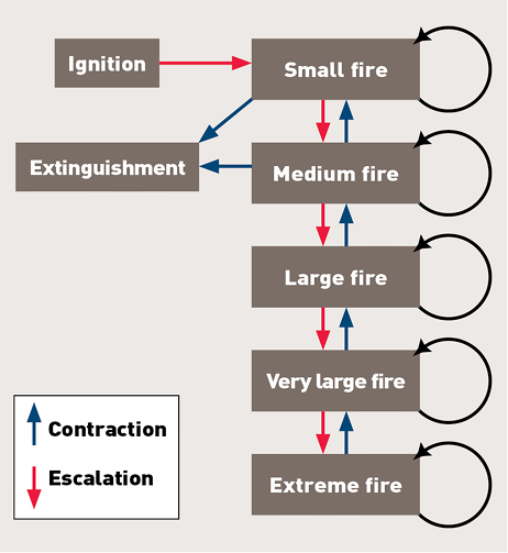
The proposed framework reflects the fact that all fires start small. It also reflects the fact that a fire will escalate or decay in size with a probability depending on the setting of the fire and the likelihood of occurrence of certain processes or events that can affect the development of a fire. For example, events such as wind changes or the incidence of extreme fire weather can cause a fire to escalate, while events such as suppression, or night time weather or rain can cause a fire to decay. The framework formally recognizes the fact that different driving factors will apply to different scales of fire. Recognising these differences in a formal way is especially important in rugged or high-country landscapes, which experience conditions that can be inherently different to less rugged or low-land sites (Sharples, 2009).
It is important to note that the transition model in Figure 1 can be viewed as an extension of the stochastic model considered by Preisler et al. (2004). Of fundamental importance to the utility of the framework is the manner in which we assign membership to the different fire severity classes.
Preisler et al. (2004) define a ‘small fire’ as one that had burnt an area of between 0.04ha and 40.5 ha, and a ‘large fire’ as one that had burnt more than 40.5 ha. However, in Preisler et al. (2004) the focus was on modelling wildfire risk based on historical fire data and so area burnt was a natural choice for the defining variable. Using the proposed framework to assess the risk posed by an evolving fire in the landscape, however, it may be more appropriate to define the size classes in terms of the average burning rate, the total intensity, or convective power of the fire, or perhaps the number of landform elements (e.g. slopes, ridge-tops, etc.) involved at a particular time. Of particular importance in these respects is the behaviour of the convective plume.
The behaviour of the convective plume that forms above a bushfire is driven by the interaction of the heat and moisture released by the fire and the characteristics of the surrounding atmosphere. Typically there is a correlation between the rate of spread or intensity of a fire and the vertical motion of the air in the buoyant, convective plume; the faster a fire spreads, consumes fuel and generates heat, the faster and higher the plume will rise (assuming that atmospheric stability is unchanging). The interaction of the convective plume with the atmosphere thus offers a plausible way of conceptualising fire severity. Indeed, Potter (2002) considers a three-stage model (surface, mixed and penetration stages) for fire development based on the extent to which the fire couples with the atmosphere above it.
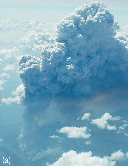
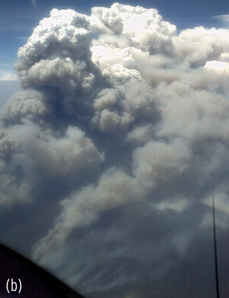
Figure 2. Aerial views of intense pyro-convective events. (a) View of intense pyro-convection, British Columbia 2001 (Photo: Noriyuki Todo, Japan Airlines). (b) Generally equivalent view, but from a lower flight height, over intense pyro-convection, Canberra Fire, 2003 (Photo: Air Target Services Pty Ltd.).
The ‘small’ and ‘medium’ fire size classes of the transition model are identified with fires burning on up to a few landform elements. Such fires are driven by interactions between fuels and meteorological conditions near the terrain surface.
In essence they are surface phenomena that involve negligible interaction with upper levels of the atmosphere (cf. the surface stage fires of Potter, 2002). The evolution of these fires should be well described by traditional approaches to modelling fire behaviour and spread. We distinguish the ‘small’ and ‘medium’ size classes to account for the way different size fires might be affected by changes in surface conditions. For example, a ‘small’ fire might respond uniformly to microclimatic conditions on a knoll, while different parts of a ‘medium’ fire might be affected in different ways by topographically-induced variations in fuel moisture and wind patterns (Sharples, 2009).
The ‘large’ fire size class involves fires burning on multiple landform elements or fires that generate enough convective power to couple with the mixed layer (the part of the atmosphere above the surface layer). Conceptually these fires are able to interact with this higher level of the atmosphere through enhanced convective mixing (cf. the mixed stage fires of Potter, 2002). Consequently these larger fires have the potential to be affected by meteorological extremes that fires in the ‘small’ and ‘medium’ size classes would not be susceptible to. Similarly the enhanced interaction of ‘large’ fires with the mixed layer permits certain processes, such as long distance spotting, which can lead to accelerated fire growth. Furthermore, owing to their spatial extent, fires in the ‘large’ size class will be subject to more variable conditions (e.g. driven by terrain-atmosphere interactions) thereby making accurate prediction of their growth more problematic.
Fires in the ‘very large’ fire size class involve numerous landform elements and consumption of large volumes of biomass. These fires generate enough heat for the convective plume to reach the top of the mixed layer and to interact with the free atmosphere above it (cf. the penetration stage fires of Potter, 2002). As such these fires have the potential to access stronger winds and very dry air, which if returned to the surface can lead to extreme levels of fire behaviour and rates of spread (Potter et al., 2007; Mills, 2005; 2008a; 2008b). Fires in this severity category would also be extremely difficult to suppress and would be very likely to do extensive damage to any assets they impacted.
If the amount of energy emitted by the fire is sufficient and the atmospheric conditions are conducive the convective plume can undergo a phase change and develop into a pyro-cumulonimbus (McRae, 2004; From et al., 2004; Damoah et al., 2006; Fromm et al., 2006; Trentmann et al., 2006; McRae et al., 2007). Photographs of violent pyro-convective events can be seen in Figure 2. A number of case studies (Tolhurst and Chatto, 1999; McRae, 2004; Fromm et al., 2006) have indicated that once the plume develops to such a level, factors such as surface meteorology, fuel characteristics and terrain become much less influential in determining fire spread. Instead fire spread is dominated by processes occurring within the plume, such as ember transport, alteration of wind flow (including downbursts) and heat transfer (Chatto and Tolhurst, 1999; Bushfire CRC, 2009). These case studies have also shown that traditional methods of fire behaviour and spread prediction perform poorly (e.g. under-predict by a factor of around 2-3) when applied to these types of fires.
In these cases the fire and the atmosphere above it have essentially become a convective storm cell. Hence this stage of fire development could properly be termed a ‘firestorm’ or, as commonly referred to in the literature, a ‘plume-driven’ fire. While fires of this type are rare they pose the most serious risk to assets; they are almost certain to cause widespread damage, burning with high intensity and are only likely to decay after encountering an extended region of reduced fuel load or a significant change in atmospheric conditions. Williams (2007) refers to these types of fires as ‘mega-fires’ and notes that in the U.S. they account for 85% of suppression costs while only totalling less than 1% of all wildfires. In terms of the transition model such fires occupy the most severe ‘extreme’ category. Consequently, knowledge of the processes that trigger violent pyro-convection will be particularly important for evaluating the likelihood of a fire escalating from the ‘very large’ to the ‘extreme’ fire size class.
Under the general assumption that larger fires cause more damage, the severity category or size class to which a particular fire belongs provides emergency managers with a measure of the potential consequences of the fire. Gill and Moore (1998) point out that this assumption is not always strictly valid, particularly in the context of damage to houses, due to the nature of the rural- or wildland-urban interface. However, if impacts on ecology, hydrology, cultural values and remote infrastructure such as substations and power lines are also considered it will mostly be the case that the greatest socioeconomic losses result from larger fires. Indeed it is highly unlikely that a small or medium fire would cause the destruction of an entire township. The fact that bushfires have only recently become of interest to insurance companies, in the wake of the recent spate of extreme events, lends further weight to this claim.
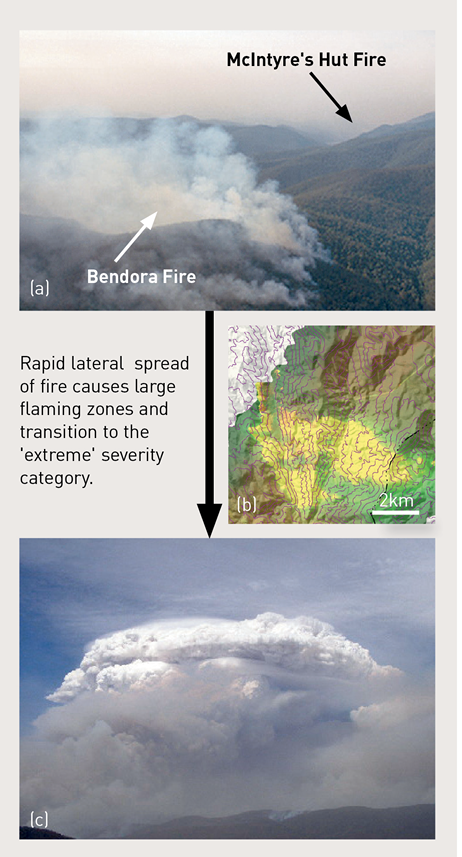
While the fire severity categories themselves are useful for conceptualising risk, the transitions between them also carry information that is fundamentally important to a complete understanding of bushfire risk. Moreover, it is this aspect of bushfire risk that is often overlooked in frameworks based on fire danger rating, which assume a fire severity continuum. For example, traditional approaches to modelling fire spread in undulating terrain often assume that since upslope acceleration will be balanced by downslope deceleration the overall result will be similar to what would be expected on relatively flat terrain (Cheney, 1968). Under this assumption rapid transition from one size class to the next would not be expected. However, Sharples et al. (2011) indicate that if the undulation in the topography exceeds some threshold then processes can occur that may cause a fire to rapidly escalate, resulting in a transition that may even skip intermediate size classes. The rapid development of the Bendora and McIntyre’s Hut fires to the west of Canberra on 18 January 2003 provides an example of this possibility (see Figure 3). The implications of such a transition for bushfire risk management are obvious.
Hence, from the point of view of risk management it is important to understand processes that can affect transition probabilities, as knowledge of them can assist in assessing the likelihood of transition to the most catastrophic class and can also provide knowledge of how to implement prescribed burning and other management strategies so as to reduce the probability of transition to the larger size classes or even to increase the chances of contraction to smaller size classes. Enhanced observation of extreme bushfires in recent years has provided researchers with the means to conduct detailed analysis of processes that can increase the probability of fire escalation (Dold et al., 2005; Finkele et al., 2006; Mills, 2008a; 2008b; Sharples et al. 2010; Sharples et al., 2011). These driving processes can greatly increase the chance of a fire transitioning to the ‘extreme’ size class. Processes that have been identified as being important include wind changes or convergences; the passage of regions of very dry upper air over active fires; wind-terrain interactions; extremely high rates of spread that may result from a combination of extreme weather, high fuel loads and steep or confined topography; enhanced spot fire development; and atmospheric instability. Fig. 3 illustrates how lateral fire spread associated with topographically forced winds can result in such a transition to the ‘extreme’ severity category.
Figure 3. Transition from a ‘medium’ to an ‘extreme’ fire driven by a fire channelling event. (a) The ‘large’ Bendora and McIntyre’s Hut fires burning to the west of Canberra on 13 January 2003 (Photo: Geoff Cutting), (b) Multispectral linescan image showing lateral development of the McIntyre’s Hut fire 15:13, 18 January 2003. The lateral development is driven by terrain-modified wind flow. (c) Pyro-cumulonimbus development over the McIntyre’s Hut fire about 30 minutes after the image in panel (b) was captured (Photo: Stephen Wilkes, NSW Rural Fire Service Air Observer).
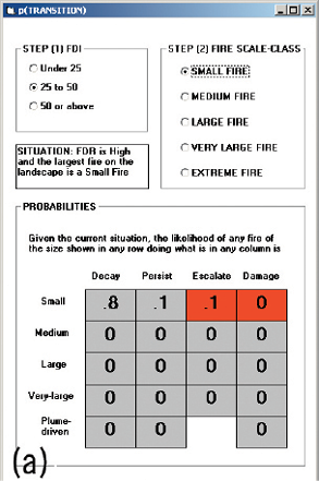
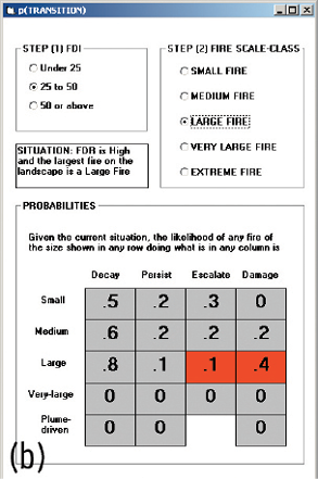
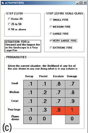
We have presented and discussed a conceptual framework designed to provide a more formal basis to bushfire risk management, and to better reflect current research into interactions between large fires and the upper atmosphere. The framework is based upon transitions between fire severity classes similar to the cyclone severity classes used in Australia. In this respect the proposed framework directly addresses Recommendation 4.3 of the Victorian Bushfires Royal Commission. The proposed framework differs from traditional methods in that it formally recognises that different size fires will be susceptible to different processes. While more research needs to be conducted to be able to formally apply the model in an operational setting, using the model as a conceptual tool can be of benefit. Figure 4 illustrates a hypothetical scenario and how the model can be used to assess the evolving risk. Viewing fires as belonging to a series of different size classes also obviates the fact that methods based on surface observations will become less valid as the fire progresses to the more severe categories.
Figure 4. An example of how the framework can be utilised. A small fire is burning in rugged terrain with high fire danger rating. In panel (a) there is an 80% chance of the fire decaying (going out) and 10% chances of persistence or escalation. There is a low likelihood of damage. In panel (b) the fire has escalated to the ‘large’ fire size class and high fire danger levels have been forecast. The chances of decay or escalation have not changed. The chance of damage has gone up, as might be expected for a larger fire. In panel (c) the fire has again escalated to a ‘very large’ fire and fire danger rating has been forecast at extreme. There is now a 10% chance of decay, a 30% chance of persistence and a 60% chance of escalation to the ‘extreme’ fire size class. Damage is essentially guaranteed.
The framework also highlights the need for more targeted research on the processes that can trigger escalation of fires to their most damaging extremes. Understanding how to mitigate and respond to the occurrence of such processes will require research that combines mathematical modelling, fire behaviour science, (severe storm) meteorology and emergency management. The framework also suggests that the community might benefit from more detailed education about the various stages of fire development. Promoting public knowledge of the severity classes and how they relate to other information such as fire danger rating forecasts would engender a more complete appreciation of the inherent risk posed by a particular bushfire.
The separation of fire severity classes emphasises the fact that certain key phenomena in the “life cycle” of catastrophic fires are confined to certain classes. Through appropriate training we can greatly improve field observations and reporting of these phenomena, and the reaction to those reports within Incident Management Teams. Supporting material is currently under development. Timely and appropriate adjustment of incident objectives and warnings to the public are an essential part of reducing the potential consequences to fire crews and the community arising from extreme bushfire events.
Cheney, N.P., 1968, Predicting fire behaviour with fire danger tables. Australian Forestry, Vol. 32, pp. 71-79.
Cruz, M.G., Gould, J.S., 2009, Field-based fire behaviour research: past and future roles. In Anderssen, R.S., R.D. Braddock and L.T.H. Newham (eds) 18th World IMACS Congress and MODSIM09 International Congress on Modelling and Simulation. Modelling and Simulation Society of Australia and New Zealand and International Association for Mathematics and Computers in Simulation, July 2009, pp. 247-253. ISBN: 978-0-9758400-7-8.
Damoah, R., Spichtinger, N., Servranckx, R., Fromm, M., Eloranta, E.W., Razenkov, I.W., James, P., Shulski, M., Forster, C., Stohl, A., 2006, A case study of pyro-convection using transport model and remote sensing data. Atmospheric Chemistry and Physics, Vol. 6, pp. 173-185.
Dold, J., Weber, R.O., Gill, A.M., Ellis, P., McRae, R., Cooper, N., 2005, Unusual Phenomena in an Extreme Bushfire. In: Proceedings of the 5th Asia-Pacific Conference on Combustion, 17-20 July 2005, The University Adelaide, South Australia.
Finkele, K., Mills, G.A., Bread, G. and Jones, D.A., 2006, National daily gridded soil moisture deficit and drought factors for use on prediction of Forest Fire Danger index in Australia. BMRC Research Report No. 119, Bureau of Meteorology, Melbourne.
Fromm, M., Bevilacqua, R., Stocks, B. and Servranckx, R., 2004, New Directions: Eruptive Transport to the Stratosphere: add Fire-Convection to Volcanoes. Atmospheric Environment, Vol. 38, pp. 163-165.
Fromm, M., Tupper, A., Rosenfeld, D., Severanckx, R., McRae, R., 2006, Violent pyro-cumulonimbus storm devastates Australia’s capital and pollutes the stratosphere. Geophysical Research Letters, Vol. 33, L05815
Gill, A.M., Moore, P.H.R., 1998, Big versus small fires: the bushfires of Greater Sydney, January 1994. In: J.M. Moreno, (Ed.), Large Forest Fires, Backhuys, Leiden.
McRae, R., 2004, Breath of the dragon – observations of the January 2003 ACT Bushfires. Bushfire 2004 Conference, Adelaide.
McRae, R.H.D., Sharples, J.J., Weber, R.O., 2007, Are big fires inevitable? Perspectives from the HighFire Risk project. Proceedings of the Joint AFAC/Bushfire CRC Conference, 19-21 September, Hobart.
Mills, G.A., 2005, On the sub-synoptic scale meteorology of two extreme fire weather days during the Eastern Australian fires of January 2003. Australian Meteorological Magazine, Vol. 54, pp. 265-290.
Mills, G.A., 2008a, Abrupt surface drying and fire weather Part 1: overview and case study of the South Australian fires of 11 January 2005. Australian Meteorological Magazine, Vol. 57, pp. 299-309.
Mills, G.A., 2008b, Abrupt surface drying and fire weather Part 2: a preliminary synoptic climatology in the forested areas of southern Australia, Australian Meteorological Magazine, Vol. 57, pp. 311-328.
Parzen, E., 1999, Stochastic processes. Society for Industrial and Applied Mathematics, Philadelphia.
Potter, B.E., 2002, A dynamics based view of atmosphere-fire interactions. International Journal of Wildland Fire, Vol. 11, pp. 247-255.
Potter, B.E., Charnet, J.J., Heilmen, W.E., Bian, X., 2007, Advances in fire convection dynamics. In: M. Furniss, C. Clifton and K. Ronnenberg, (Eds.), Advancing the Fundamental Sciences: Proceedings of the Forest Service National Earth Sciences Conference, San Diego, CA, 18-22 October 2004, PNWGTR-689, Portland, OR: U.S. Department of Agriculture, Forest Service, Pacific Northwest Research Station.
Preisler, H.K., Brillinger, D.R., Burgan, R.E., Benoit, J.W., 2004, Probability based models for estimation of wildfire risk. International Journal of Wildland Fire, Vol. 13, pp. 133-142.
Sharples, J.J., 2009, An overview of mountain meteorological effects relevant to fire behaviour and bushfire risk. International Journal of Wildland Fire, Vol. 18, pp 737-754.
Sharples, J.J., Mills, G.A., McRae, R.H.D., Weber, R.O., 2010, Foehn-like winds and elevated fire danger conditions in south-eastern Australia. Journal of Applied Meteorology and Climatology, Vol. 49(6), pp 1067-1095.
Sharples, J.J., McRae, R.H.D., Wilkes, S.R., Weber, R.O., 2011, Wind-terrain effects on the propagation of large wildfires in rugged terrain: fire channelling. International Journal of Wildland Fire, under review.
Teague, B., McLeod, R., Pascoe, S., 2009, 2009 Victorian Bushfires Royal Commission Interim Report. Parliament of Victoria. Available from: www.royalcommission.vic.gov.au/Commission-Reports/Interim-Report
Tolhurst, K.G., Chatto, K., 1999, Development, behaviour and threat of a plume-driven bushfire in west-central Victoria. In: K. Chatto, (Ed.), Development, behaviour, threat and meteorological aspects of a plume-driven bushfire in west-central Victoria: Berringa Fire February 25-26, 1995. Research Report No. 48. Fire Management, Department of Natural Resources and Environment.
Trentmann, J., Luderer, G., Winterrath, T., Fromm, M.D., Servranckx, R., Textor. C., Herzog, M., Graf, H.-F., Andreae, M.O., 2006, Modelling of biomass smoke injection into the lower stratosphere by a large forest fire (Part I): reference simulation. Atmospheric Chemistry and Physics Discussions, Vol. 6, pp. 6041-6080
Victorian 2009 Bushfire Research Response Final Report October 2009, 2009, Victorian Bushfires 2009 Research Taskforce Interim Report June 2009. Bushfire Cooperative Research Centre, Melbourne. Available from: www.bushfirecrc.com
Williams, J., 2007. The mega-fire reality: re-directing protection strategies in fire-prone ecosystems. Bushfire CRC Forum, Are Big Fires Inevitable, 27 February 2007, Canberra, Australia. Available from: www.bushfirecrc.com/events/downloads/Jerry-Williams-Final.pdf
Rick McRae is from the ACT Emergency Services Agency. Majura, ACT Australia.
Jason Sharples is from the School of Physical, Environmental and Mathematical Sciences, University of New South Wales at the Australian Defence Force Academy. Canberra, ACT Australia.
They can be contacted at: rick.mcrae@act.gov.au or j.sharples@adfa.edu.au. Also visit http://www.highfirerisk.com.au