Editor's Note: The NDMP in 2009/10 became part of the Natural Disaster Resilience Program. This paper was submitted and reviewed prior to the recent floods in Queensland.
The vulnerability of developed floodplains to extreme rainfall events, particularly under climate change, is increasing; and their vulnerability to inundation has been highlighted in the 2007 Intergovernmental Panel on Climate Change (IPCC) report, particularly in chapter 7 which relates specifically to industry, settlement and society. In Australia natural disasters such as bushfires, floods, landslides and cyclones cause serious disruptions to communities and cause approximately $1 billion in damages annually to homes, businesses and infrastructure, with this figure likely to increase as a result of the impending impacts of climate change (BTE, 2001).
Floods in Australia typically account for 29% of the costs resulting from natural disasters (BTE, 2001). The insurance industry in Australia has broadly classified floods according to three categories: flash flooding, riverine flooding and sea level rise or storm surge (Insurance Council of Australia, 2010). One mechanism by which increases in the costs of disasters is likely to occur relates to the ‘sea change’ phenomenon. This phenomenon has resulted in increased urbanisation of coastal areas in Australia with a consequent increased population at risk of exposure to natural disaster events associated with climate change such as flooding from sea level rise (DOCC, 2009).
An assessment undertaken of the risk of climate change to Australia’s entire coastal zone was compiled by the Australian Government Department of Climate Change (DOCC) in the report ‘Climate Change Risks to Australia’s Coasts’. It found that between 35,900 and 56,900 residential buildings along the Queensland coastline were located within 3 kilometres horizontally and 6 metres vertically of the shoreline (DOCC, 2009a). The report concluded that Queensland residential buildings at risk of a sea level rise of 1.1 metres were valued between $10.5 and $16 billion dollars, the second highest level of any state in Australia (DOCC, 2009a). Mackay was included as one of the top six Local Government Areas in Queensland that collectively represented 85% of these residential buildings at risk of inundation along the Queensland coastline (DOCC, 2009a). Additionally, the IPCC 2007 report found flooding in inland areas such as Charleville may become worse in the future under climate change scenarios in which extremes of both flood and drought will be amplified.
In the paper ‘Adaptation to Environmental Change: Contributions of a Resilience Framework’, Nelson et al. (2007) conclude that adaptation is “a process of deliberate change in anticipation of or in reaction to external stimuli and stress” which takes into consideration Smit’s (2000) definition where human adaptation techniques are either ‘autonomous’ or ‘planned’. Planning and development that both mitigate and augment the adaptive capacity to flood disaster events through building and engineering solutions have been addressed in Australia by the National Disaster Mitigation Program (NDMP)1 which identifies and addresses natural disaster risk priorities (AGD, 2009). Australia’s Regional Flood Mitigation Program, which was rolled into the NDMP in 2007, invested $75 million in 270 projects over the program’s eight year duration comprising: construction of levees, house raising, flood proofing buildings, bypass floodways, flood control dams, retarding basins, channel improvements, flood warning systems and activities to raise community awareness (AGD, 2009). Legislation is another approach that addresses climate change mitigation and assists adaptation. Different jurisdictions in Australia have different disaster planning policy approaches for example Victoria has promoted a ‘retreat’ policy to the threat of coastal inundation from sea level rise and associated storm surge; whilst New South Wales has advocated the position of ‘defence’, endorsing engineering solutions (see Table 1).
Table 1. Flood related disaster planning legislation and policy in Australia.
| Australian State/Territory | Emergency Management Legislation | Planning legislation | Flood mitigation planning policy | Coastal legislation | Coastal Policy | Sea level rise benchmark |
|---|---|---|---|---|---|---|
| Australian Capital Territory (ACT) | Emergencies Act 2004 | Australian Capital Territory (Planning and Land Management) Act 1988 | Floodplain Protection Guidelines | N/A | N/A | N/A |
| New South Wales (NSW) | State Emergency and Rescue Management Act 1989 | Environmental Planning and Assessment Act 1979 | State Environmental Protection Policy Flood Prone Land Policy and Floodplain Development Manual 2005 | Coastal Protection Act 1979 Coastal Protection and Other Legislation Amendment Act 2010 | Draft NSW Coastal Planning Guideline: Adapting to Sea Level Rise | 40cm by 2050 & 90cm by 2100 |
| Northern Territory (NT) | Disaster Act 2008 | Planning Act 2009 | No specific legislation | NT Marine and Coastal Biodiversity Management Strategy being developed | Not stated | |
| Queensland | Disaster Management Act 2003 | Sustainable Planning Act 2009 | State Planning Policy 1/03: Mitigating the Adverse Impacts of Flood, Bushfire and Landslide | Coastal Protection and Management Act 1995 | Draft Queensland Coastal Plan – Draft Guideline Coastal Hazards | Draft – 30cm by 2050 & 80cm by 2100 |
| South Australia (SA) | Emergency Management Act 2004 | Development Act 1993 | Coast Protection Act 1972 | Under review – Coastal Planning Information Package | 30 cm by 2050 & 100cm by 2100 | |
| Tasmania | Emergency Management Act 2006 | Tasmanian Planning Commission Act 1997 | No specific legislation | Revised Draft State Coastal Policy 2008 | Not stated | |
| Victoria | Emergency Management Act 1986 | Planning and Environment Act 1987 | SPPF Coastal Areas policy (Clause 15: 08-2) | Coastal Management Act 1995 | Victorian Coastal Strategy 2008 | 80cm by 2100 |
| Western Australia (WA) | Emergency Management Act 2005 | Planning and Development Act 2005 | State Planning Police No. 3.4: Natural Hazards and Disasters 2006 | No specific legislation | Statement of Planning Policy 2.6: State Coastal Planning Policy 2003 (under state planning legislation) | 38cm by 2100 |
Sources: Emergency Management Australia (2008; AGD, 2009); Briggs et al. (2010)
Research was undertaken to determine the effectiveness of disaster planning policy approaches in Australia by assessing the Queensland State Planning Policy 1/03: Mitigating the Adverse Impacts of Flood, Bushfire and Landslide (SPP 1/03) which was introduced in 2003 as a statutory instrument under the Integrated Planning Act 1997 (now superseded by the Sustainable Planning Act 2009 (SPA)) and the Statutory Instruments Act 1992. The focus of this policy is to mitigate against the disaster impacts of natural hazards on communities and the environment, and to effectively create more resilient communities including households and businesses under Queensland state planning legislation. This is of particular importance given the recently enacted Queensland Sustainable Planning Act 2009 (SPA) which will cause state planning policies to expire after ten years. The key themes of the SPP 1/03 are:
Prior to introduction of the SPP 1/03 there was no planning policy in Queensland that imposed any restrictions to developments in natural hazard prone areas. Floods have been recognised under Emergency Management Legislation throughout jurisdictions in Australia and planning for floods was first recognised in New South Wales planning legislation under section 55 (2)(d) of the Environmental Planning and Assessment Act 1979 (Table 1). However, Queensland was the first state in Australia to introduce a state planning policy in 2003 specifically aimed at mitigating floods with New South Wales subsequently releasing in 2005 the Flood Prone Land Policy and Floodplain Development Manual. The introduction of the SPP 1/03 has resulted in mitigation measures being introduced into local government planning schemes and the development of strategic regional plans to prevent urban development in areas particularly vulnerable to natural hazards. According to the SPP 1/03, the Queensland Government’s position is: “The appropriate flood event for determining a natural hazard management area (flood) is the 1% Annual Exceedance Probability (AEP) flood.” (Annex 3, A3.2).
The research undertaken was a qualitative study which focused on reconstructing an event recording the actions taken at the various stages of the Integrated Emergency Management System in relation to the Charleville and Mackay 2008 flood disaster events.
The study used a purposive sampling research design that was composed of three phases of quantitative and qualitative data collection in the form of questionnaires and face-to-face structured and semi-structured interviews (Kreuger and Neuman, 2006). Each phase of data collection was targeted at a different group of stakeholders: household residents, businesses and institutions. The sample sizes and response rates are given in Table 2 with the low response rates for Mackay households explained by the large proportion of the sample either not home at the time the survey was undertaken or not present during the floods, having moved into the house following the event.
Table 2: Total sample and response rates.
| Sample Group | Statistical group | Charleville | Mackay | Total |
|---|---|---|---|---|
| Households | Number contacted | 65 | 400 | 465 |
| Effective in-scope sample | 55 | 87 | 142 | |
| Response rate | 85% | 22% | 31% | |
| Businesses | Number contacted | 15 | 142 | 157 |
| Effective in-scope sample | 13 | 47 | 70 | |
| Response rate | 87% | 33% | 44% | |
| Institutions | Number contacted | 30 | 38 | 68 |
| Effective in-scope sample | 23 | 12 | 35 | |
| Response rate | 77% | 32% | 41% |
The questionnaire asked whether they had required approval of a development under the SPP 1/03 and respondents were asked to rate its effectiveness.
The rural town of Charleville is situated west of Brisbane and is the main town servicing the Central West region (Wagner, 1991). The Charleville population grew around the agricultural industry from 1871 to peak in 1961 with 5,154 people and then declined to a population of 3,278 recorded at the 2006 Australian Census of Population and Housing (CGQ, 2009; ABS, 2006). The decline in population is reportedly linked to the downturn in the pastoral industry, fluctuating sheep-wool and cattle prices, a number of poor seasons and the effect of rising operational costs (Lord, 1982).
Charleville lies on a floodplain in the heart of Queensland’s mulga country on the left bank of the Warrego River and was laid out in the form of a grid by a Government surveyor (Wagner, 1991). The Bradley’s Creek catchment covers 200 km2 and flows through Charleville running almost parallel to the Warrego River before it discharges into the Warrego River downstream of the town (Sargent, 1991). Charleville has a low average rainfall of 450mm but the township has historically been flooded by the Warrego River numerous times to the point where the flood disaster event of 1997 led to the construction of a levee to protect the town (figure 2; BOM, 2009).
Figure 2. History of flooding of the Warrego River at Charleville.
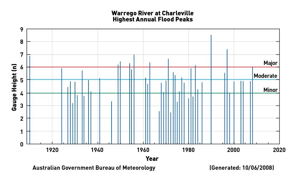
Source: BOM (2009)
The January 2008 flood was not caused by the flooding of the Warrego River but by the riverine flooding of Bradley’s Gully which flows through the township of Charleville (BOM, 2009). Flooding occurred over 3 days from 17 to 20th January 2008 and it was the largest Bradleys Gully flood event since 1963 with floodwaters reaching approximately 3.1 metres (BOM 2009).
Approximately 40 businesses and residents in the lower-lying areas of Charleville and some hospital patients were evacuated (ABC, 2008). There were 920 families assisted through the Natural Disaster Relief and Recovery Arrangements (NDRRA) grants totalling over $446,000 in Emergency Assistance and Essential Household Contents Grant payments (pers. Comm. Jill Peters. Community Recovery Unit, Queensland Department of Communities, Brisbane, 23-12-2009). There were 96 primary producers that received grants to the value of $1.341 million and several other small business grants and concessional loans paid out to primary producers under NDRRA (QRAA, 2010). The total cost of the restoration of essential public assets was estimated at $2.5 million by the Queensland Department of Infrastructure and Planning (pers. comm. Allan Pemberton, Murweh Shire Council, 2-11-09). Emergency Management Queensland counter disaster operations costs for Murweh Shire totalled $216,000, whilst no freight subsides were paid out to primary producers by the Department of Employment, Economic Development and Innovation (pers. Comm. Stephen Hinkler, Queensland Department of Community Safety, 18-01-2010).
The city of Mackay, situated in Northern Queensland, was established in 1860 by explorer and harbourmaster John Mackay on an expedition in search of northern grazing land, and was founded on an estuarine wetland floodplain (Mackay Family History Society Inc., 2009). The township has developed, including reclaimed wetlands areas, around the port and services that support the primary industries of the region such as the large mining and agricultural sectors (REDC, 2009). The Mackay statistical division is a relatively wealthy area in comparison with many other regions of Australia with 10-16% of households earning a gross income of $2500 or more per week with almost 50% of workers employed in construction or mining-related professions (46.7%; ABS, 2006; ABS, 2008).
The history of flooding from the Pioneer River is illustrated in Figure 3 and records date back to 1884 (BOM, 2009). The highest occurring flood recorded was in February 1958 which peaked at a height of 9.14 metres on the Mackay flood warning gauge at the Forgan Bridge (BOM, 2009). The February 2008 flood was not a riverine flood but a flash flood, caused by intense local rainfall, with the river peaking at only seven metres (BOM, 2009).
Figure 3. History of flooding of the Pioneer River at Mackay.
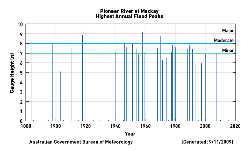
Source: BOM (2009)
On 15 February 2008 the Bureau of Meteorology (BOM) Mackay Alert automatic gauging station located in North Mackay recorded a total 24 hour rainfall of 629.2 mm and classified the rainfall as a synoptic scale event (BOM, 2008).
Mackay’s annual rainfall is between 1600 – 2000 mm and February’s average rainfall based on records since 1959 records is 326.7 mm and median rainfall 275.2 mm (BOM, 2009). Twice the city’s monthly average rainfall and almost a third its annual rainfall fell within six hours on the morning of 15 February 2008 between 3:00am and 9:00am.
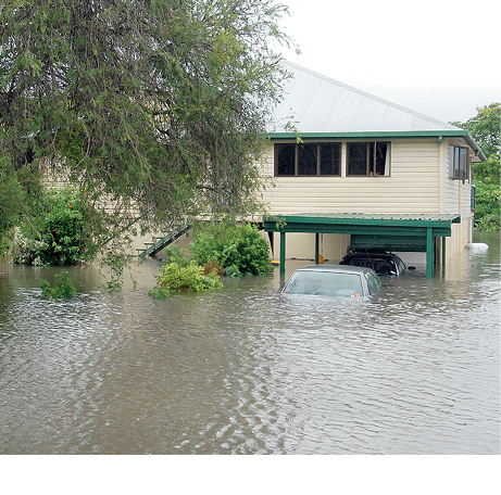
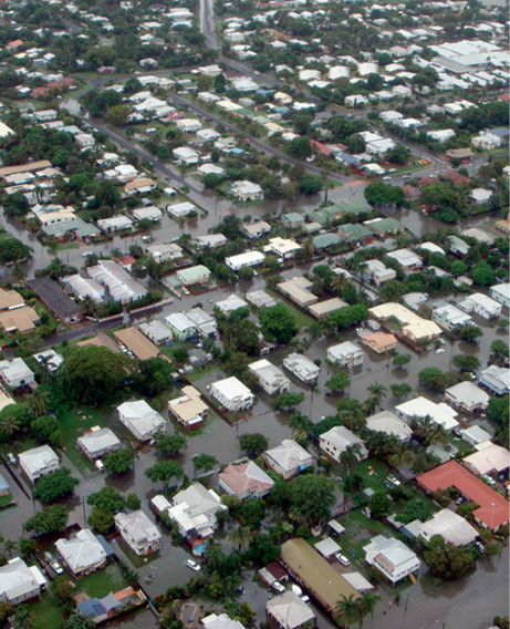
The whole city of Mackay was affected by the rainfall but the worst impacts were caused by a wave of runoff which travelled from the north-west in Glenella and followed the Gooseponds creek using roads as channels in an effort to get out to sea through the city. This wave of runoff caused the most significant disaster impacts, resulting in the greatest impacts in the low lying, sloped areas of the suburbs of Glenella and North Mackay. It was particularly notable that in the suburbs of Glenella and North Mackay, residences located adjacent to new in-fill developments, which were former wetland areas, appeared to receive the greatest amounts of water in their homes.
The State Emergency Service (SES) responded to approximately 2000 calls for assistance during the 2008 Mackay floods (EMA, 2008). The floods resulted in disruption to power and telecommunications, overflow of sewerage stations into an estimated 200 homes, people trapped in their homes and vehicles, and closure of the airport and roads into the city (Courier Mail, 2008). Six evacuation centres were established and there were two deaths associated with the floods (EMA, 2008). Post disaster dangers included water passages which enabled crocodiles to travel to and within urban, more populated areas (Courier Mail, 2008).
More than $419 million in infrastructure and contents damage occurred as a result of the floods. The Insurance Council of Australia (ICA) recorded a total of $410 million in claims of flood damage to private residences including buildings and contents, cars, rural fences, business interruption, motor cars and business (ICA, 2009). Many insurance companies did not cover riverine flood damage in Mackay due to the high likelihood so if the February 2008 flood had not been a result of flash flooding but a riverine flood, many insurance companies would not have covered the damage. This would have left flood impacted households and businesses at greater economic vulnerability which would have increased the impacts on the Mackay community. Expenditure by government institutions in response and recovery operations to the floods was in the millions, for example, the Department of Transport and Main Roads alone spent $9.3 million on public infrastructure repairs following the 2008 Mackay floods.
An estimated 200 homes experienced disruption to power, telecommunications and an overflow to sewerage systems.
This study highlights the creative solutions that enable development to continue on flood-prone areas and key findings relating to research on the SPP 1/03 are listed in Table 3. The levee construction in Charleville has created a flood-proof mindset which has resulted in reverting to building on slabs as opposed to raising the floor level. Loopholes in the Mackay City Planning Scheme 2006 that enable extensions to existing developments were also detected. This case study shows the difficult task of forward planning in towns built on historic planning decisions where restrictions for building above flood lines were only introduced in 2003.
Table 3 outlines the limits to the implementation of the SPP 1/03 in both Charleville and Mackay including mitigation measures attempted and those omitted, misconceptions and loopholes. The case study examples of Charleville and Mackay are illustrative of many issues in other councils throughout the state.
Table 3: Summary of findings relating to the SPP 1/03: Mitigating the adverse impacts of Flood, Bushfire and Landslide.
| Town | Findings |
|---|---|
| Charleville |
|
| Mackay |
|
The importance of planning is highlighted in a changing climate where this study reveals that a greater disaster event is only a matter of time for the city of Mackay and other similar coastal cities built on floodplains. Alarm was raised amongst Mackay residents in the two years following the 2008 disaster event when flash floods were forecast in February 2009 as a tropical low, a remnant of former tropical cyclone Ellie, crossed the coast and again in March 2010 from tropical cyclone Ului (Daily Mercury, 2010; MRC, 2010). Moreover, Charleville was flooded again by Bradley’s Gully in March 2010 which demonstrates the town’s vulnerability when around a third of the population in Charleville had to be evacuated and flood waters from Bradley’s Gully cut through the centre of the town (BOM, 2010; ABC, 2010).
A rebuild of parts of the city was required after the floods.
The substantial costs required to rebuild following flood damage may result in unaffordable insurance premiums leaving a cleanup bill to be paid. Historically natural disasters have caused insurance companies to become insolvent and costs have been passed onto government agencies and ultimately tax payers (Salt, 2003). This raises the question of who should pay for the costs associated with climate change. The risks associated with climate change have caused increasing concern amongst the Australian population. This has been evidenced at the federal level where politics has been dominated in the last three years by significant decisions relating to climate change policy. For example, it has been suggested that the 2007 federal election was won on the key election promise to ratify the Kyoto Protocol and that confidence was said to have been lost in the Labor government because of its failure to deliver an Emissions Trading Scheme (Flannery, 2010). In attempting to address the costs associated with climate change, whilst government will inevitably be required to play a role as extreme weather events result in natural disasters, greater responsibility should be placed on individuals to consider the impacts of climate change in their own risk assessments.
Australians continue to make the lifestyle choice of living by the beach and councils face significant liability concerns under climate change where the legislative responsibilities are often held by local governments and so the trend by both state and federal governments has been to devolve responsibility for decision making and costs to the local council level (Gold Coast City Council, 2010). Local governments feel as though they face a no-win liability situation under climate change scenarios (Gold Coast City Council, 2010). They are afraid that they will be sued if they approve developments in flood prone areas but are equally concerned that they will be taken to court if they do not allow development along the coast, as in the recent case where landowners took the South Gippsland Shire Council to VCAT ([1545] 2008) in relation to the Victorian state planning policy that requires councils to identify and avoid development in areas susceptible to flooding. Despite the case brought by the landowners being unsuccessful, it highlights that coastal policies such as the Victorian approach are having the effect of reducing coastal property values which could also lead to an alteration in former real estate market trends over time as impacts from climate change compound. Approaches in other jurisdictions have cost local governments such as the recent court proceedings between Byron Shire Council and a local resident where the court upheld an owner’s right to protect their property from sea level rise in Byron Bay, New South Wales (Briggs et al, 2010).
Instruments are currently being designed at both state and federal levels that address the increased impacts on infrastructure resulting from climate change. For example, Queensland’s coastal policy, the ‘Queensland Coastal Plan’, is in draft form and likely to include measures that recognise a rise in sea level by incorporating a height above which buildings must be constructed and a sliding scale from 800 mm above current sea level which is unclear as to how this will be assessed (DERM, 2010a). Emergency Management Queensland currently uses the ‘Guidance for considering climate change in Natural Disaster Resilience Program funded projects in Queensland Guidelines’, issued by the Department of Climate Change, when assessing the funding of disaster recovery projects to ensure that alterations that recognise resilience to climate change impacts are considered in future design (DOCC, 2009b). Engineers Australia is in the process of updating the Australian Rainfall and Runoff (ARR) tables used currently by engineers to incorporate climate change models (Engineers Australia, 2009).
The recent changes in Queensland planning legislation will have the effect of overriding local government policies. This may result in increased destruction from natural disasters where state government policy that aims to encourage development and economic activity overrides initiatives by local governments – for example in the case of Mackay, where local government planners have been trying to influence state planning policy to introduce stronger measures to prevent development in areas susceptible to flooding. The introduction of an expiry date for all state planning policies could create havoc for the Integrated Development Assessment System (IDAS) in three years time when this policy is due to expire at the end of 2013.
The changes in Queensland’s planning legislation have already been enacted to slow the development of wetlands in the Great Barrier Reef Catchments by the introduction of the Temporary State Planning Policy 1/10 Protecting Wetlands of High Ecological Significance in Great Barrier Reef Catchments, which was released in May 2010 by the Department of Environment and Resource Management (DERM, 2010b). This will require any developments on wetlands in the Great Barrier Reef catchment area to undergo a specific assessment and will also assist in reducing the severity of floods by allowing overland flows and ground water infiltration. This is the first planning policy that has been enacted in Queensland by joint Ministers, the Honourable Kate Jones MP, Minister for Climate Change and Sustainability, and the Honourable Stirling Hinchliffe MP, Minister for Infrastructure and Planning, under the new legislation included in chapter 2, part 4, division 3 of the Sustainable Planning Act 2009 (SPA; DERM, 2010b). The introduction of this policy indicates the state recognition of the threat of wetlands in the Great Barrier Reef catchment to development as requiring urgent protection. It should be noted that the current status of this policy is ‘temporary’ so will expire within a year under SPA.
Policy solutions that rely heavily on emergency management as distinct from solving or mitigating problems at source during development may be considered as negligent under climate change scenarios. Planning policy solutions which effectively address development patterns in floodplains are critical to increasing the resilience of communities and decreasing the cost of natural disaster recovery. The emergence of coastal planning policies that address storm surge flooding from sea level rise should be consistent with disaster flood mitigation planning policy to ensure their effectiveness as flood mitigation tools and provide resilience to climate change impacts. The SPP 1/03 needs to be revised to increase its effectiveness, to incorporate the projected impacts of climate change and to ensure that it is harmonious with Queensland’s coastal policy.
We would like to thank the National Climate Change Adaptation Research Facility (NCCARF) for funding this work.
We would like to extend our appreciation to all the Charleville and Mackay householders, businesses and personnel from institutions for sharing valuable insights on the 2008 floods. Thank-you to Yetta Gurtner from the Centre for Disaster Studies for reviewing the Emergency legislation.
Some portions of this journal article were also published in the Conference Proceedings from the Engineers Australia ‘Practical Responses to Climate Change National Conference 2010’, 29 September – 1 October 2010.
Attorney-General’s Department (AGD) (2009), Emergency Management in Australia [Online]. Australian Government. Available: http://www.ema.gov.au/ [Accessed 23 May 2010].
Australian Broadcasting Commission (ABC) (2008), Charleville town inundated in water from Bradley Gully. Available: http://abc.net.au/local/stories/2008/01/18/2141596.htm [Accessed 4 November 2009].
Australian Broadcasting Commission (ABC) (2010), Hundreds evacuated from flood-bound Charleville. Available: http://www.abc.net.au/news/stories/2010/03/02/2834213.htm/ [Accessed December 2009].
Australian Bureau of Statistics (ABS) (2006), Census of Population and Housing, Canberra.
Australian Bureau of Statistics (ABS) (2008), National Regional Profile: Mackay (Statistical Division) [Online]. Canberra. Available: http://www.abs.gov.au [Accessed 16 February 2010].
Australian Institute of Marine Science (AIMS) (2007), Floods muddy waters off the Great Barrier Reef [Online]. Townsville: Australian Government. Available: http://www.aims.gov.au [Accessed 30 January 2010].
Bates, B. C., Kundzewicz, Z. W., Wu, S. and Palutikof, J.P. (2008), Observed and projected changes in climate as they relate to water. In: Secretariat, I. (ed.) Climate Change and Water: Technical Paper VI. Geneva: Intergovernmental Panel on Climate Change (IPCC),.
Bennett, S. (2000), “New approaches to assessing vulnerability and resilience”, Australian Journal of Emergency Management, 15, 8-15.
Briggs, P., Taberner, J., Voros, M. and Bilski, A. (2010), Climate change litigation to flood planning and development in coastal areas, Freehills.
Bureau of Meteorology (BOM) (2008), Report on Queensland Floods: February 2008, BOM, Queensland.
Bureau of Meteorology (BOM) (2009), available: www.bom.gov.au [Accessed 6 March 2010].
Bureau of Transport Economics (BTE) (2001), Economic Costs of Natural Disaters in Australia. ACT.
Centre for the Government of Queensland (CGQ) (2009), Charleville, The University of Queensland [Online]. Available” http://queenslandplaces.com.au/charleville [Accessed 21 December 2009].
Cooper, T. F., Gilmour, J. P. and Fabricius, K. E. (2009), ‘Bioindicators of change in water quality on coral reefs: review and recommendations for monitoring programmes’, Coral Reefs, 28: 589-606.
Daily Mercury (2009), Nth Qld braces for more rain, floods [Online]. Available: http://www.dailymercury.com.au [Accessed 17 July 2010].
De’eath, G., and Fabricius, K. E. (2008), Water Quality of the Great Barrier Reef: distributions, effects on biota and trigger values for the protection of ecosystem health, Final report to the Great Barrier Reef Marine Park Authority, Australian Institute of Marine Science, Townsville, Australia.
Department of Climate Change (DOCC) (2009a), Climate Change Risks to Australia’s Coasts: A First Pass National Assessment, Australian Government, Canberra.
Department of Climate Change (DOCC) (2009b), Guidance for considering climate change in Natural Disaster Resilience Program funded projects in Queensland, Commonwealth of Australia.
Department of Environment and Resource Management (DERM) (2009), Queensland Wetland Map Version 2.0: MACKAY – 8755. Queensland Government.
Department of Environment and Resource Management (DERM) (2010a), Draft Queensland Coastal Plan, Queensland Government.
Department of Environment and Resource Management (DERM) (2010b), Temporary State Planning Policy: Protecting Wetlands of High Ecological Significance in Great Barrier Reef Catchments, Queensland Government.
Elsner, J. B., Kossin, J. P. and Jaggar, T. H. (2008), “The increasing intensity of the strongest tropical cyclones”, Nature, 455, 92-95.
Emergency Management Australia (2008), EMA Disasters Database [Online]. Australian Government. Available: http://www.ema.gov.au [Accessed 12 January 2010].
Engineers Australia (2009), Australian Rainfall & Runoff Revision Project [Online]. Available: http://www.engineersaustralia.org.au [Accessed 13 June 2010].
Flannery, T. (2010), ‘Plenary Session’, National Climate Change Adaptation Research Facility (NCCARF) 2010 International Climate Change Adaptation Conference, 29 June – 1 July 2010, Gold Coast.
Gippsland Coastal Board v South Gippsland Shire Council & Ors (No. 2) [2008] VCAT 1545
Gold Coast City Council (2007), Gold Coast Planning Scheme: Our Living City, Gold Coast.
Gold Coast City Council (2010), ‘Public Seminar’, National Climate Change Adaptation Research Facility (NCCARF) 2010 International Climate Change Adaptation Conference, 28 June 2010, Gold Coast.
Great Barrier Reef Marine Park Authority (GBRMPA) (2003), Great Barrier Reef Marine Park Zoning Plan, Australian Government, Townsville.
Great Barrier Reef Marine Park Authority (GBRMPA) (2009), Great Barrier Reef Outlook Report 2009, Commonwealth of Australia, Townsville.
Insurance Council of Australia (2009), Personal Commonunication from Assoc. Prof. Armando A. Apan and Assoc. Prof. David King, RE: Total insurance claims paid in Mackay in 2008, FYI, No information available for Charleville, 13 November 2009.
Insurance Council of Australia (2010), Consumer tips: Flood Insurance in Australia.
Intergovernmental Panel on Climate Change (IPCC) 2007 ‘Climate Change (2007): Impacts, Adaptation and Vulnerability’, Report of the Intergovernmental Panel on Climate Change, E. M.L. Parry; O.F. Canziani; J.P. Palutikof; P.J. van der Linden and C.E. Hanson, Contribution of Working Group II to the Fourth Assessment,. Cambridge, UK, Cambridge University Press: 976.
King, D. (2007), ‘Government, Non Government and Community Organisations in Disaster’, in David King and Alison Cottrell (ed.), Communities Living with Hazards. Centre for Disaster Studies, James Cook University, Townsville.
Kreuger, L. W., and Neuman, W. L. (2006), Social Research Methods: Qualitative and Quantitative Approaches, Allyn and Bacon.
Lord, M.A. (1982), Murweh Shire 100 Years of Local Government 1880-1980, Western Times, Charleville.
McCook, L. J., Jompa, J. and Diaz-Pulido, G. (2001), “Competition between corals and algae on coral reefs: a review of evidence and mechanisms”, Coral Reefs, 19, 400-417.
Mackay Family Hsitory Society Inc. (2009), Early Settlers of Mackay 1860-1885, Queensland Government.
Mackay Regional Council (2006), Mackay City Planning Scheme, Mackay Regional Council.
Mackay Regional Council (MRC) (2010), Clean up has started after Tropical Cyclone Ului [Online]. Available: http://www.mackay.qld.gov.au [Accessed 17 July 2010].
Nelson, D. R., Adger, W. N. and Brown, K. (2007), “Adaptation to Environmental Change: Contributions of a Resilience Framework”, Annual Review of Environment and Resources, 32, 395-419.
Nicholson, P. (2005), “Hurricane Katrina: Why Did the Levees Fail?”, American Society Society of Civil Engineers, Committee on Homeland Security and Governmental Affairs, U.S. Senate, Washington.
Queensland Rural Adjustment Authority (QRAA) (2010), Assistance Provided to the Murweh and Mackay Shires as a result of the Queensland Monsoonal Flooding event in January & February 2008, Queensland Government, Brisbane.
Regional Economic Development Corporation (REDC) (2009), Regional Economic Profile, Mackay.
Sargent, D.M. (1991), “The Western Queensland Floods – April 1990”, International Hydrology & Water Resources Symposium, Perth, 2-4 October, 935-940.
Salt, J. E. (2003), The insurance industry: Can it cope with catastrope? in Pelling, M. (ed.) Natural disasters and development in a globalizing world, Routledge, London.
Shaw, M., Negri, A., Fabricius, K., and Mueller, J. F. (2009), “Predicting water toxicity: Pairing passive sampling with bioassays on the Great Barrier Reef”, Aquatic Toxicology, 95.
Smit, B. (2000), ‘An Anatomy of Adaptation to Climate Change and Variability’, Climatic Change, 45: 223-251.
Staff reporters (2008), “Mackay emergency as 625mm deluge in three hours floods city”, Courier Mail.
Victorian Coastal Council (2008), Victorian Coastal Strategy, Melbourne.
Wagner, C. (1991), Frontier Town Charleville 1865-1901, Boolarong Publications, Bowen Hills, Brisbane.
Melanie Thomas is a research worker for the Centre for Disaster Studies at James Cook University.
Associate Professor David King is the Director of the Centre for Disaster Studies and the Director for the Centre for Tropical Urban and Regional Planning, at James Cook University.
Dr Diane Keogh is a Lecturer at Central Queensland University.
Associate Professor Armando A. Apan, is Associate Dean (Research) for the Faculty of Engineering and Surveying & Group Leader of the Spatial Analysis and Modelling Australian Centre for Sustainable Catchments, University of Southern Queensland.
Dr Shahbaz Mushtaq is the Deputy Director for Research at the Australian Centre for Sustainable Catchments, University of Southern Queensland.

