Rapidly defining the extent of a new incursion of an invasive species shares similar challenges to emergency response strategies, particularly emergency animal disease (EAD) responses. In an EAD response, defining distinct areas such as infected premises (IP), restricted area (RA) or control area (CA) are vital for compartmentalising response strategies and minimising risks of further spread of organisms (Animal Health Australia 2002, Anon 2006). For EADs, declaration of designated areas is dependent on a number of factors. Many of these relate specifically to livestock production such as defining the industries involved, livestock movement patterns or livestock products. However, some factors are generic and could be used for defining potential areas for invasive species. These include identifying environmental factors and potential barriers, and understanding the species involved and the nature of the outbreak (Animal Health Australia 2001). A compartmentalisation approach to a new incursion of an invasive species would therefore maximise efficient use of resources, both to detect and define the new incursion in a timely manner and reduce the risk of spread. The incursion by Common starlings, Sturnus vulgaris, in south-western Western Australia was used to test these propositions.
The starling was originally introduced to south eastern Australia in the nineteenth century (Long 1981). As in other parts of the world, the starling spread rapidly and established large populations throughout eastern Australia, causing damage to agriculture and the environment and becoming a social nuisance (Tracey et al. 2007). The spread of starlings in Australia has been restricted by a number of geographic barriers including deserts. Movements into Western Australia (WA) have been limited by the semi-arid Nullarbor Plain and more than 30 years of ongoing control work at the western edge of the main distribution of starlings (Figure 1, Woolnough et al. 2005). However, there have been a number of incursions into WA and these infestations have either been eradicated or are subjected to ongoing control (see Woolnough et al. 2005).
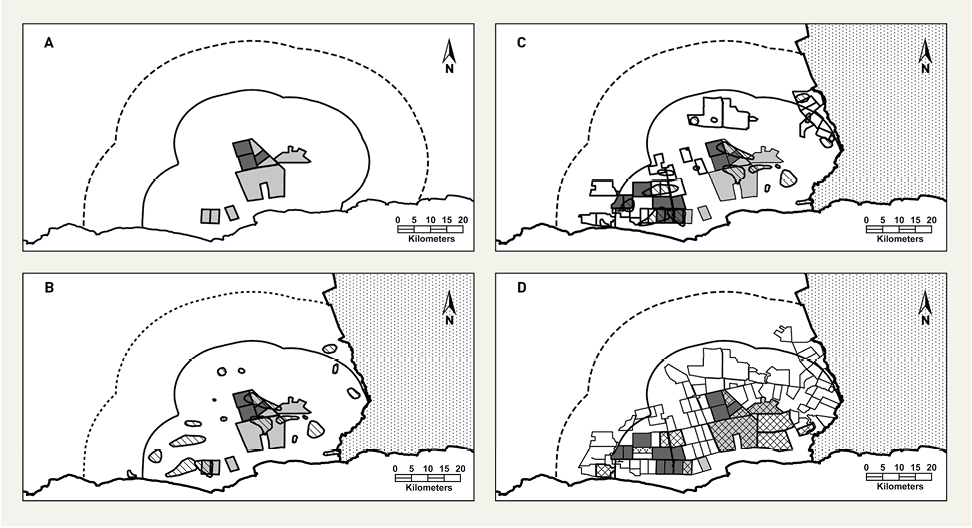
Figure 1. Generalised distribution of starlings in south eastern Australia (shaded) adapted from Birds Australia atlas data (www.birdata.com.au), excluding low density records in north Queensland and Western Australia. The emergency response was situated at the boundary of the Ravensthorpe and Esperance Shires (local government boundaries).
There are compelling economic arguments that it is cost-effective to control starlings in WA before they become widely established (Roberts and Cramer 2006). When an infestation of starlings was detected near the town of Munglinup in south-eastern WA in 2001 they were subjected to concerted control efforts. However, in February 2006, a report from a landholder resulted in the confirmation of a new infestation at Jerdacuttup more than 30 km to the west of the Munglinup infestation. Immediately, an emergency response was initiated to define the western-most distribution of this new infestation using the principles of EAD response strategies. Here, it is demonstrated how the principles of EAD responses were used and how the underlying generic strategies can be adapted for biosecurity emergency responses, such as the detection and quantification of a new incursion of an invasive species.
Part of adapting EAD principles is using the terminology, although some liberal interpretation may be required (e.g. ‘infected’ cf ‘infested’). Definitions are widely available in EAD response in many manuals (see Animal Health Australia 2001, Gaynor and McAteer 2003, Anon 2006) but may vary slightly between jurisdictions.
Like diseases, invasive species do not recognise land tenure as a boundary or barrier. Nevertheless, land tenure is often used as a management unit in EAD responses and the same pragmatic course was used in this exercise.
After starlings were first detected on a property at Jerdacuttup in the Ravensthorpe Shire in February 2006, follow-up surveillance detected starlings on two adjacent properties. Consequently, 3 IPs were defined and an additional 6 suspected infected premises (SPs) were identified through preliminary reconnaissance and intelligence from highly experienced starling control officers (Figure 2).
Figure 2. Location of the three infected premises (IPs – dark shade) and six suspected infected premises (SIPs – light shade). The control area (CA) is compartmentalised by an inner buffer of 15 km (Protection Zone or PZ – solid line) and an outer buffer of 30 km (Surveillance Zone or SZ – dashed line), with the buffers set about the IPs and SIPs.
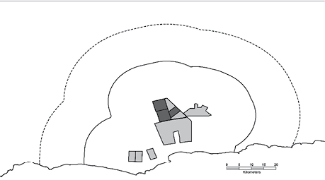
A two-zone strategy was implemented to define the CA in a similar manner to an EAD Protection Zone (PZ) and Surveillance Zone (SZ) strategy (see Gaynor and McAteer 2003). Unlike EAD manuals, this incident did not have any disease-specific distance measurements to define the area of each zone. Analogous EAD criteria were used to define zones. However, sound epidemiological principles and natural boundaries could be used to define each zone. The inner zone (equivalent to the PZ) was defined as the maximum span of short-term home ranges used by starlings centred about the IPs and SPs. This distance was conservatively set at 15 km, based on radio telemetry data from a starling infestation immediately to the east of the IPs (Woolnough et al. 2006, Woolnough et al. unpublished data). The outer zone (equivalent to the SZ) was defined as twice the maximum span of short-term home ranges used by starlings, or 30 km. This was based on a demographic assessment that it was unlikely (see Higgins et al. 2006), but not impossible, that the starlings from the IPs or SPs would move no further than the PZ and that any birds detected towards the edge of the PZ would move no further than the edge of the SZ. In this way, all likely encounters directly related to the IPs or SPs should be accounted for.
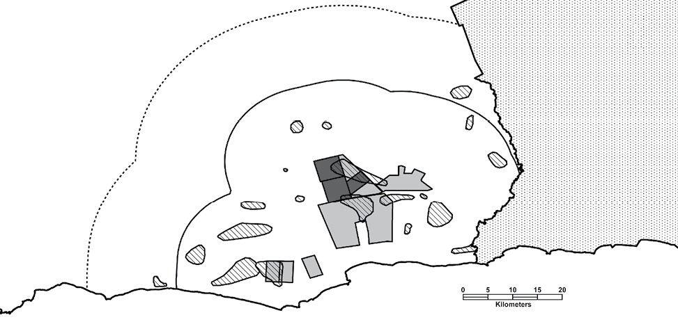
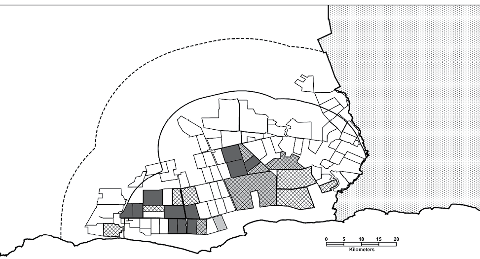
Using the buffer feature of a GIS (Geomedia V6.0) to create the PZ and SZ, area estimates of these two CA components were 2,250 km2 and 4,700 km2 respectively. This clearly represented a very large area in which to detect low density, cryptic birds. Consequently, the CA was delineated to the east by the local government boundary (Figure 3) and surveillance efforts were concentrated in the western three quarters of the CA. This focus on the western region of the CA was chosen as the most critical front for starlings in Western Australia (i.e. western most boundary), rather than for any definitive biological reason.
Figure 3. Because of the large area of the CA, surveillance efforts are restricted to the Ravensthorpe Shire to the west. The eastern edge of the CA is delineated by the Ravensthorpe-Esperance Shire boundary. Stippled area east of Shire boundary (Esperance Shire) was excluded from the final PZ and SZ. High priority target areas, identified by aerial surveys, are indicated in diagonal fill. Other features are described in the caption for Figure 2.
Land use in the CA is primarily mixed farming, with cropping, grazing (sheep and cattle) and feedlots cattle (Woolnough et al. 2006). A common feature of the habitat of the CA is the many permanent and seasonal swamps surrounded by Saltwater Paperbarks (Melaleuca cuticularis) and/or Yate trees (Eucalyptus occidentalis). Other habitat characteristics of the CA include remnant tracts of native vegetation (dominated by Banksia spp. and Eucalyptus spp.), particularly along riparian strips, road-sides, property boundaries and fence lines, and introduced stands of Tasmanian blue gums (E. globulus) used for wind breaks or plantations.
Starlings in south-western WA are often associated with swamp habitats, which they use for shelter and breeding. Surveillance used these habitats as focal points. However, within the CA there are more than 430 swamps. Because of time constraints similar to an EAD response, rather than assess each individual swamp for suitability, an assessment was made by aerial survey. Priority areas (PAs) to be targeted for surveillance were then selected on the basis of scores. Two observers flew east-west transects over the CA and independently scored each swamp on a three-point scale. Where the scores differed, the score of the most experienced observer was used. This observer had over 100 hours of aerial radio-tracking starlings in similar habitats, so was familiar with preferred starling habitat from the air. This is an important point, since interpretation of habitat from the air can be much different than from the ground.
An emergency incident centre was established which was equivalent to a Local Disease Control Centre (LDCC; Animal Health Australia 2004). Key roles at the LDCC included an LDCC controller, a logistics manager, a mapping officer, a land holder liaison officer, a public relations officer and team leaders for the field surveillance teams. Many of the roles and responsibilities outlined in the Animal Health Australia (2004) manual were incorporated into the roles outlined above, with some participants taking on multiple roles. In all, 24 staff were engaged for the week-long emergency response, with additional staff involved prior to and after the response.
Surveillance was undertaken by three teams of four and one team of five observers (N = 17) experienced in observing birds and familiar with starlings. Surveillance was undertaken in two shifts per day (early morning and late afternoon) to maximise the opportunities at times when starlings were most active moving into and out of roost areas. For each surveillance session, teams were allocated to one of the 20 PAs (Figure 3), with surveillance concentrated on swamps and surrounding pastures. When starlings were detected, and confirmed by multiple observers, teams moved on to other swamps and priority areas. If starlings were not observed, a combination of observer judgement and pre-set criteria for the minimum observing time (3 hours by 2 observers per swamp) was used by the surveillance team leaders to determine that properties and/or swamps were not infested. Each team recorded details of time spent at each location, whether starlings were sighted, how many starlings were sighted and at what time. More specific details on observations of starling behaviour or suitability of a particular swamp for starlings were recorded separately for subsequent follow-up investigations. Results of each surveillance session were reported in a twice-daily debrief. The LDCC controller reallocated PAs based on information from each debrief. Central to this process was the rapid generation of detailed aerial photographs, superimposed with cadastral boundaries and ownership information, produced by the mapping officer.
Following this exercise, ongoing surveillance and control strategies were developed to clarify the western-most boundary of the new infestation.
Four hundred and fifteen swamps were visually assessed from the air of which 158 were deemed suitable for starling habitation. These were allocated into 20 PAs for surveillance, with each targeted area covering multiple swamps (Figure 3).
Over 575 person-hours of surveillance were undertaken in the week-long emergency initiative, not including the > 850 person-hours in pre-deployment planning and preparation. This allowed for comprehensive surveillance of 30 properties selected within the CA. The owners/managers of these priority properties were contacted in person and briefed prior to teams conducting investigations. Of the 158 swamps targeted for surveillance from the 30 properties, 97 of these were investigated in detail.
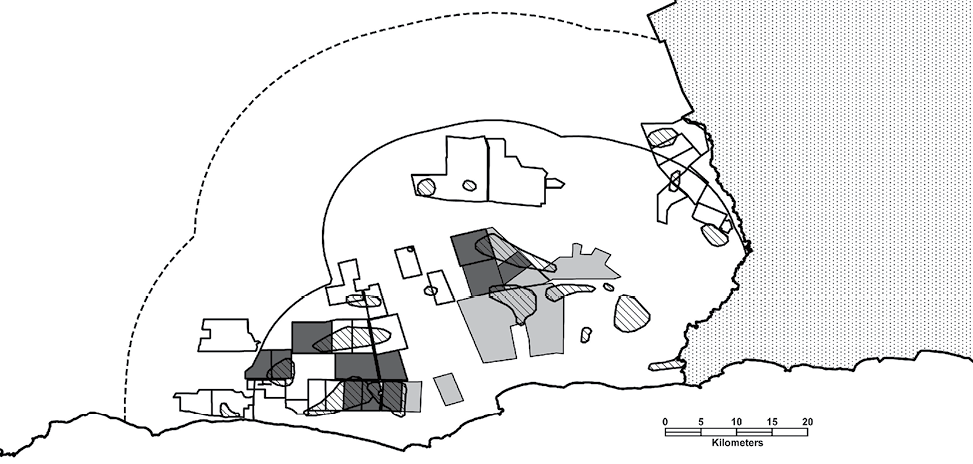
In addition to the IPs, six additional properties were found to have infestations of starlings during the initial emergency response, including one of the SPs (Figure 4). Independent (time distinct) counts of starlings detected individual birds, as well as flocks of up to 60 birds.
Figure 4. Results of the emergency response including existing and new IPs (dark shade), properties surveyed that were clear from infestations (no shade) and the SIPs (light shade). Other features are described in the captions for Figures 2 and B.
Subsequent to this emergency response, surveillance of all potentially infested properties in the Ravensthorpe Shire (N = 64), until December 2006, found starlings on another 10 properties, bringing the total number of IPs to 20 (Figure 5). This represents a surveillance and control effort of more than 2250 person-hours, investigating 192 swamps, including all of the high priority swamps.
Figure 5. Results of ongoing surveillance in the CA until December 2006. Cross hatching represents properties where starlings have been detected following the initial emergency response, along with all properties surveyed without infestations (no shade). Other features are described in the captions for Figures 2, 3 and 4.
The success of the emergency response in this exercise was largely due to adherence to the overarching principles contained within emergency response plans. Furthermore, this example demonstrates that the generic principles outlined in plans such as AUSVETPLAN, can readily be applied in other similar biosecurity emergencies. In this case, it was the rapid detection and quantification of a new incursion of an invasive species, the common starling in WA.
In Australia, the biosecurity sector has a number of emergency response plans that are sector-specific: PLANTPLAN for emergency plant pests, AUSVETPLAN for terrestrial animal disease management, AQUAVETPLAN for aquatic animal disease management, and CCIMPE for marine pests. These plans share similar fundamentals and constructs including organism control strategies, enterprise manuals, management manuals and operational documents (Murray and Koob, 2004). It is interesting to note, that apart from the Wild Animal Response Strategy (Animal Health Australia 2005) of AUSVETPLAN, vertebrate pests are largely overlooked in these biosecurity strategies. Evidence presented here suggests that the generic principles in these management manuals are sufficient to form the basis of real-life emergency response procedures in invasive species emergencies. Furthermore, there is perhaps no need to develop a different strategy for invasive species.
The concept of a generic set of policies, strategies, operational and tactical arrangements for all types of biosecurity incidents is being developed by the Emergency Risk Management Unit, Australian Government Department of Agriculture, Fisheries and Forestry (Peter Koob, personal communication). It is important that the relevance of invasive species (plants and animals) is considered when the preparedness and response strategies are agreed upon for each biosecurity sector.
The EAD management manuals are also suitable to develop appropriate training programs and scenario-based simulations (e.g. Saunders and Bryant 1988, Anon 2002, Koob 2004). In this scenario, training for one of the key roles was provided by participation in a field-based EAD exercise (Exercise WIldThing; Anon 2002). Field-based training provides unanticipated outcomes that require real-time responses and solutions. For example, Saunders and Bryant (1988) demonstrated that the compartmentalisation of the CA, though ecologically well-founded, was inadequate to anticipate the additional dispersal pressures created by persecution of the feral pig population, and that a level of flexibility in the management of the scenario was vital to achieve eradication of the disease from the feral pig population. Likewise, in this scenario, the LDCC needed to respond immediately to reports from the field to deploy teams in the most meaningful way to quantify the western front of the infestation. Even though desk-top exercises are very useful, particularly for refining high-end policy making and communication strategies (Koob 2004), nothing can replace the suite of challenges created during field-based testing of a simulated emergency response or indeed the lessons learnt from a real-life emergency response (Tarrant 2006).
Using the EAD analogy, the immediate rapid emergency response did not achieve complete containment. However, using the same strategic approach, the complete extent of the infestation was eventually defined. This demonstrates that the underlying principles were robust and applicable.
Additional challenges with starling control and eradication continue. Following the defining of the extent of the infestation, we could easily use the principles of emergency response to suggest that we have entered a period of response and recovery within a preparedness, prevention, response and recovery (PPRR) framework. However, the length of time that this may take is presently unclear. Nonetheless, following an emergency management framework (PPRR or its derivatives; see Tarrant 2006) will lead to a better understanding of how this and future incursions of starlings need to be managed into the future. The principles of emergency management could also be considered for general management of invasive species. For example, a biosecurity emergency response strategy may provide policy and management support for setting priorities or allocating resources for invasive species within an increasingly resource-demanding sector. For this to occur, it is important that there is a multidisciplinary approach to biosecurity emergency management, including invasive species emergency management, and that there be a strong ethos of knowledge sharing, cooperation and the capacity to adapt within the sector.
The emergency response was primarily funded by the Department of Agriculture and Food, with support from the Department of Environment and Conservation and Birds Australia, Western Australia. Numerous people assisted with the emergency response and their input is greatly acknowledged. Special mention for key roles includes Marion Massam (Incident Manager/Public Relations Officer), Ron Payne and Garry Gray (Logistics Managers), Kate Steward (Mapping Officer), Lisa Jolly (Landholder Liaison Officer), and John Bruce, Ted Knight and Col Parry (Field Surveillance Team Leaders). I thank Tony Higgs, Garry Gray, Gary Martin and Ken Rose for comments on the manuscript.
Animal Health Australia, 2001, Disease strategy: Foot-and-mouth disease. (Version 3.0). Australian Veterinary Emergency Plan (AUSVETPLAN), Edition 3, Animal Health Australia, Canberra, Australia. http://www.aahc.com.au/ausvetplan/index.html (accessed February 2007).
Animal Health Australia, 2002, Summary document (Edition 3.0). Australian Veterinary Emergency Plan (AUSVETPLAN), Edition 3, Animal Health Australia, Canberra, Australia. http://www.aahc.com.au/ausvetplan/index.html (accessed February 2007).
Animal Health Australia, 2004, Management manual: Control centres management Part 1: Management and organisation of control centres (Edition 3.0). Australian Veterinary Emergency Plan (AUSVETPLAN), Edition 3, Primary Industries Ministerial Council, Canberra, Australia. http://www.aahc.com.au/ausvetplan/index.html (accessed February 2007).
Animal Health Australia, 2005, Wild Animal Response Strategy (Version 3.2). Australian Veterinary Emergency Plan (AUSVETPLAN), Edition 3, Primary Industries Ministerial Council, Canberra, Australia. http://www.aahc.com.au/ausvetplan/index.html (accessed February 2007).
Anon, 2002, Exercise wild thing: report and review. A Report to the Wildlife and Exotic Disease Preparedness Program, Australian Government Department of Agriculture, Fisheries and Forestry, Canberra, Australia.
Anon, 2006, Terrestrial animal health code. 15th Edition. OIE Publications, Paris, France. http://www.oie.int/eng/en_index.htm (accessed February 2007).
Gaynor, S. and McAteer, B., 2003, Foot and mouth disease operations manual. Department of Agriculture and Food, Dublin, Ireland. http://www.agriculture.gov.ie/index.jsp?file=publicat/fmd_manual/contingency_plan.xml (accessed February 2007).
Higgins, P.J., Peter, J.M. and Cowling, S.J., 2006, Handbook of Australian, New Zealand and Antarctic Birds. Volume 7. Boatbill to Starlings. Oxford University Press, Melbourne.
Koob, P., 2004, Improving Australian animal health emergency preparedness – the experience of Exercise Minotaur. The Australian Journal of Emergency Management, Vol. 19, No.3, pp. 66-69.
Long, J.L., 1981, Introduced birds of the world. A.H. and A.W. Reed, Sydney.
Murray, G. and Koob, P., 2004, Biosecurity in Australian agriculture. The Australian Journal of Emergency Management, Vol. 19, No.3, pp. 5-8.
Roberts, J. and Cramer, R., 2006, Starlings in Western Australia. Assessing the likely cost of an incursion. Unpublished Report, ACIL Tasman, Perth, Australia. http://www.invasiveanimals.com/images/pdfs/Starling_Incursion_Report_-_Final_Report_-_191206_2.pdf (accessed February 2007).
Saunders, G. and Bryant, H. (1988). The evaluation of a feral eradication program during a simulated exotic disease outbreak. Australian Wildlife Research Vol. 15, No.1, pp. 73-81.
Tarrant, M., 2006. Risk and emergency management. The Australian Journal of Emergency Management, Vol. 21, No.1, pp. 9-14.
Tracey, J., Bomford, M., Hart, Q., Saunders, G. and Sinclair, R., 2007, Managing bird damage to fruit and other horticultural crops. Bureau of Rural Sciences, Canberra.
Woolnough, A.P., Lowe, T.J. and Rose, K. (2006). Can the Judas technique be applied to pest birds? Wildlife Research, Vol. 33, No.6, pp. 449-455.
Woolnough, A.P., Massam, M.C., Payne, R.L. and Pickles, G.S., 2005, Out on the border: Keeping starlings out of Western Australia. Proceedings of the 13th Australasian Vertebrate Pest Conference, Wellington, pp. 183-189.
Dr Andrew Woolnough is the Discipline Leader of the Department of Agriculture and Food’s Vertebrate Pest Research Section. An ecologist with an interest in applied and theoretical invasive species biology, Andrew contributes to strategic pest management in order to keep Western Australia free from starlings. He can be contacted at andrew.woolnough@agric.wa.gov.au

