In the past few years if we have learned anything about emergency management and weather related disasters it is that they are unpredictable. Many studies and models have been developed regarding planning and preparation for such occurrences (Schaffer, 2010). Emergency management organisations at various governmental levels will choose a model based on their specific requirements or possibly budgetary restrictions. But in either case, detailed planning will generate individual Courses of Action (COA) due to different scenarios obtained from a model. When situations arise that do not follow the model then the Emergency Operations Center (EOC) and the Incident Commander (IC) are thrown into a foot race to create a new COA because time can mean everything in disaster situations, as noted with the western US wildfires during the summer of 2010, Hurricane Katrina (Sovada, 2008), and the earthquake devastation in Haiti relief effort (Cruz, 2010).
The military is probably the best benchmark for plan development and having an alternate plan ready for implementation. This may be due to a common saying within the military, ‘no plan survives first contact with the enemy’ (Moltke et al., 1993). Not that the overall plan is forgotten but a strategy of ‘adapt and overcome’ is implemented to move beyond the roadblocks to success. A part of that adaptive nature is feedback. New information is obtained and a new plan is generated in order to continue the mission. In today’s planning environment, technologic advancements in Intelligence, Surveillance and Reconnaissance (ISR) fill a large part of that feedback loop.
“ISR is the integrated capability to task, collect, process, exploit, and disseminate accurate and timely intelligence” (U. S. Air Force, 2002). This is a critical function for the military commander to have in order to successfully plan and conduct operations. The timely input of new information allows for personnel and equipment to be utilized in the most effective manner possible. The assets that are tasked to collect the required information encompass satellites, manned, and unmanned vehicles; these same capabilities are becoming available to civilian disaster planners particularly in settings where federal and state (e.g. National Guard) resources become involved. A growing area of ISR is within the unmanned aerial vehicle (UAV) community. Some examples of UAV’s are Predator and Global Hawk. The Department of Defence defines UAV’s as ”a powered aerial vehicle that does not carry a human operator, uses aerodynamic forces to provide vehicle lift, can fly autonomously or be piloted remotely, can be expendable or recoverable, and can carry a lethal or nonlethal payload”(Staff, 2007). In 1982 the Israelis proved how useful UAV’s can be when conducting operations in the Bekaa Valley, Lebanon. Israeli forces used unmanned systems for ISR and to activate Syrian air defence systems, allowing other aircraft and surface-to-surface missiles to destroy the now active air defences (US Air Force). In subsequent years, a US joint services program developed the RQ-1 Predator system. The US Air Force in 1996 eventually took control of the program. A growing area of UAV capability is in the disaster relief support role.
After the 7.0 magnitude earthquake hit the country of Haiti, a Global Hawk was tasked to provide high altitude damage assessment imagery. The priority was to capture images of key infrastructure such as airstrips, bridges, and ports throughout the country, where relief efforts could gain entrance to reach injured and trapped people (Force,15 January 2010). In 2007, a Predator was acquired by NASA for earth science studies, technology development, and possible support of wildfire fighting in the western United States. Within that year NASA received a request for assistance from the National Interagency Fire Center and the California Office of Emergency Services. The Predator was equipped with a thermal-infrared imaging system, capable of seeing through heavy smoke and darkness to identify hot spots, flames, and temperature differences (NASA, 2007). The collected data was sent to NASA’s Ames Research Center where it was overlaid on Google Earth maps, then transmitted in near real time to the Interagency Fire Center in Boise, Idaho, to assist fire incident commanders in allocating their resources (NASA, October 2007).
Linked ISR systems fit within the Systems-of-Systems engineering paradigm defined as “an interoperating collection of component systems that produce results unachievable by the individual systems alone.” (Haskins, 2007). The integration of ISR systems with the emergency management system could serve the EOC and the IC with the same timely and accurate information needed to convert the current reactive modelling process into a dynamic process in order to keep pace with fluid, real world events.
Eveleigh (2005) proposed combining a systems engineering design model with a geospatial model to improve disaster management. Eveleigh concluded that “this technique has great potential to advance disaster management practice and help disaster managers understand the complex interface between natural, human and technological systems.” (Eveleigh, 2006). This paper will explore the advantages of incorporating a systems engineering approach to developing a feedback loop for decision makers in the emergency management system. The paper will begin with a flooding hazard model identifying the critical infrastructure nodes and decomposing those nodes into a free body wire diagram. The wire diagram will be used to reduce background noise and highlight the targeted points of interest. A perspective of the US Department of Defence Architecture Framework (DoDAF) will be introduced for possible modelling of the physical and functional architectures during a disaster. The use of the DoDAF architecture-derived modelling framework will be evaluated and conclusions will be discussed.
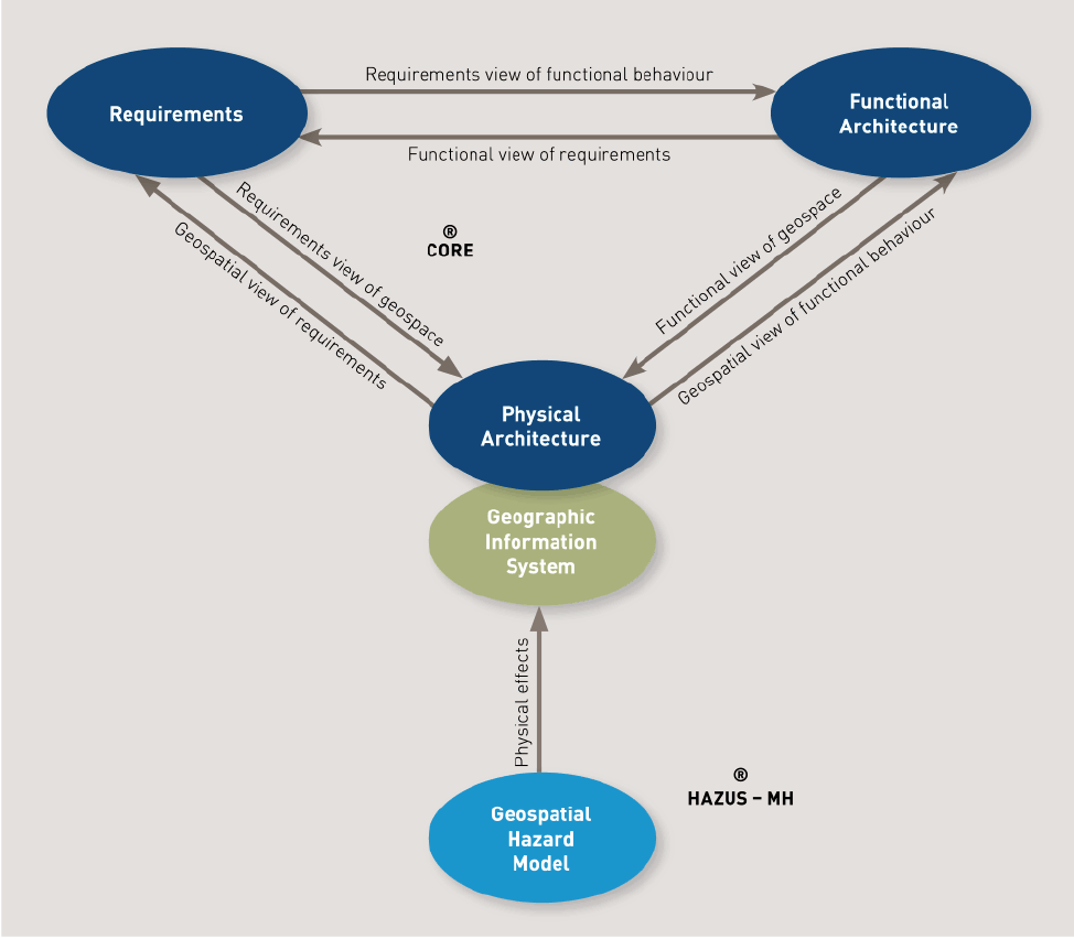
This study takes the methodology introduced by Eveleigh and extends it in a dynamic way. In Eveleigh’s study, a systems engineering design approach was taken that linked modelled disaster requirements to a functional architecture representing disaster response system behaviours and a physical architecture representing a realizable solution. Additionally, a Geographic Information System (GIS) (Figure 1) was used to augment the physical architecture to assign its elements to real world objects and locations (e.g. bridges, roadways, buildings) (Eveleigh, 2006). The combined systems engineering design/geospatial model was shown to provide a new methodology for disaster management practitioners as it was able to couple physical effects (e.g. flooding, wind damage) to physical infrastructure that provided critical response system functions (e.g. evacuation, fire protection, safe havens).
Figure 1: Geographic Information System (Adapted from Eveleigh, 2006).
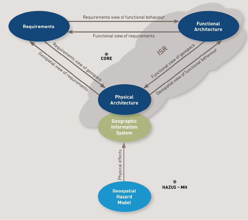
When ISR is integrated into the disaster management process shown above we get a new and dynamic view of the changing physical world. ISR will provide the feedback on specific ‘targeted’ points of interest that have been developed in the planning phases of disaster management or due to ‘ad hoc’ requirements that arise in real world events (Figure 2). ISR has the potential to update the content of the infrastructure GIS keeping it more current as well as to monitor and confirm the ongoing effects of a natural hazard e.g. flooding, wind effects. This approach will not only keep the models more current and potentially capable of tracking the progressive failure (and recovery) of function-providing infrastructure but will allow ISR assets to be used more effectively by allowing them to be focused on the monitoring of critical physical nodes.
Figure 2: Geographic Information System (integrated model).
ISR is a process used by the military for many years. This process includes the integrated capabilities to task, collect, process, exploit, and disseminate accurate and timely information (Baier and Rower, 2002). The collected information must be exploited and fused with other sources of exploited data to form valuable information prior to dissemination. In our improved model, ISR provides fresh information on the modelled physical architecture through geospatial analysis. Part of that analysis will also include information on the functional architecture allocated to physical elements of the sensed infrastructure. “Functional and material flows are useful means to portray and model dependency between functions” (Eveleigh et al., 2006). Eveleigh has shown with his combined model that disaster management functional architectures can be decomposed into networks of functions which are linked to geospatial objects. Our approach, like his, models physical infrastructure using ESRI’s ArcGIS software and hazard effects using FEMA’s HAZUS-MH “Multi Hazard” disaster modelling program. Depending on the disaster type or hazard to be mitigated, some geospatial objects will require a higher degree of scrutiny or ‘targeting’ than others as they are linked to critical nodes in the disaster management functional model. For example, a certain bridge may be a key physical node in the system of features that are allocated to a “provide regional evacuation” functional model. When disaster effects (e.g. coastal and riverine flooding, wind blast) are generated by HAZUS-MH the geospatial objects at greater risk are identified by their role in the functional model. A Functional Flow Block diagram can then be created to show the infrastructure (main roadways, hospitals, elderly care facilities, power and communications centres) without background clutter for clarity. Since the functional architecture is in turn linked to the geospatial objects, a target list can be quickly generated that will identify hazards to the functional architecture. The target list can then be evaluated by the EOC or the IC for possible ISR collection with target priority. ISR assets would be tasked to provide imagery or Full Motion Video (FMV) for analysis and feedback to the EOC or IC.
Modelling with HAZUS-MH for flooding and following Eveleigh’s approach of tying functionality to physical locations allowed us to identify infrastructural elements providing essential functionality in danger of flood inundation that should be targeted for ISR monitoring. When ISR is incorporated into the modelling process, the resulting architecture framework is shown in Figure 3. The architecture will be described below.
Figure 3: Functional flow block diagram.
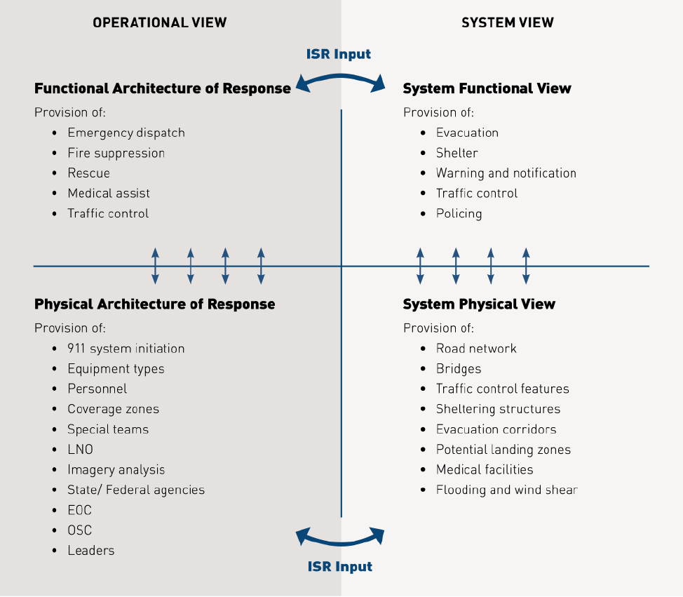
We adapted the DoDAF viewpoint structure to show the linkage between the operational context and the system context and how they relate to ISR input. However, for disaster response, a new paradigm on the DoDAF architecture emerged. System views will describe the systems within the community or region involved in the disaster. Within that system, a system physical view contains the physical features that make up the region which are elements that can provide an actual service. The system functional view models the functions of those features. The operational views represent the emergency management system and its attributes within a functional and physical response to the disaster. The operational function of the response will show what the emergency management response activities could be. And the operational physical architecture of the response will identify the ‘who’ and the ‘where’ of the response. The ISR input for the functional views will provide information on the degradation of system element functionality and of disaster response. Lastly, the ISR input for the physical views will provide status of community physical elements, damage assessments and timely updates for determining physical elements in danger of rising flood waters.
A combined model was proposed by Eveleigh (Eveleigh et al., 2006) which explored physical effects from disasters and their impact on both the physical and functional architecture of a disaster management (DM) system. A natural extension for the combined model was to provide a dynamic capability to DM decision makers using ISR. ISR has been used in conjunction with previous disasters but only as a tool for generalized monitoring, not treated as a system to be integrated into the larger DM system. “At the operational level, the ISR community did not have an ISR plan ready to rapidly provide damage assessments following a catastrophic natural disaster within the United States” (Sovada, 2008, US Air Force, October 2005). Using a systems engineering modelling methodology, we have developed an architecture for incorporating ISR into DM. The modified DoDAF viewpoints will allow us to “move away from looking at isolated situations and their causes, and start to look at the disaster system as a system made up of interacting parts” (Simonovic, 2011). When reviewing the modified DoDAF architecture we start in the lower right quadrant and move counter clockwise through the four separate views. When a disaster strikes a community, the system physical view in the lower right quadrant will be impacted first. As the physical elements become damaged we follow view linkages to DM functions allocated to the physical elements and can access functional damage to the community DM systems. This can be seen in road networks being damaged which will then impact the evacuation function. In the upper left quadrant, the emergency functional response will respond to the community functional damage. An example of this is simply the emergency response system responding to the community ‘system’ functional needs. Based on the emergency functional response, we move to the lower left quadrant to determine asset response, i.e. specific teams and equipment that will support the functional response. In other words, if the functional response requires fire suppression then the physical response will be the Firefighters and fire trucks. We then move back across to the lower right community ‘system’ physical view. The response physical elements are tied to the community ‘system’ physical view through the asset and team physical location within the community. The counter clockwise spiral will continue to move through the quadrants in a tightening loop with ISR feedback. The ISR feedback will provide timely analysis of the damaged element functionalities and/or the recovery of the physical elements.
ISR imagery analysis for targeted infrastructure will provide real time information that could allow equipment and personnel to work longer in dangerous areas. For populated areas with limited roadway access, the roadways often form choke points as rising flood waters begin to deny alternate routes. As the roadways close down, a UAV could provide an over watch function on the last remaining open roadways. This will prevent sending personnel out to each potential choke point in order to just sit, observe and report as the waters rise. Personnel numbers will be at a premium and should be employed in much more productive way. However, UAV’s are the recommended asset for missions that are considered dull, dirty, and dangerous (Cruz, 2010; Cambone, 2005). With the capability to loiter over a target for extended periods of time, the UAV is well suited for this tasking. UAVs could potentially provide imagery (including radar) and real time information to ground crews as to when they must leave to prevent being trapped.
We have shown that the addition of ISR to the disaster management system and decision making process can provide the dynamic facet needed for real time feedback modelling. The modified DoDAF viewpoints have shown how the ISR system could be merged with the disaster management system model to create a new combined system model that is adaptable and responsive. While ISR may have been used in previous disaster responses, the planning and coordination needed to effectively merge the two systems fell short. Neither the ISR community nor the disaster management community had developed any pre-planning for working together. We have shown how the establishment of a systems engineering architecture model can be utilized to insert ISR into the disaster management system. We believe that this will assist the disaster management community to understand the complex relationships that exist between the ISR community, decision makers, and the physical/functional architecture during and after a disaster.
Baier, F. & Rower, N. 2002. Information Operations. In: Force, U. S. A. (ed.). HQ AFDC/DR.
Cambone, S. A. 2005. Unmanned aircraft systems roadmap 2005-2030, Washington D.C., Defense Technical Information Center.
Cruz, H. L. 2010. Role of DoD Unmanned Aerial Vehicles for Homeland Security. Masters.
Eveleigh, T., Mazzuchi, T. & Sarkani, S. 2006. Systems engineering design and spatial modelling for improved natural hazard risk assessment. Disaster Prevention and Management, 15, 636-648.
Eveleigh, T. J. 2006. An approach for combining a systems engineering design model with a geospatial model for improved disaster management and impact modelling. THE GEORGE WASHINGTON UNIVERSITY.
FORCE, U. S. A. 15 January 2010. 480th ISR Wing Supports Disaster Relief Efforts. Print News Today [Online]. Available: http://www.acc.af.mil/news/story.asp?id=123185802 [Accessed 17 January 2010].
Haskins, C. 2007. Sysytems Engineering Handbook A Guide for Sysytem Life Cycle Processes And Activities. In: INCOSE (ed.).
Moltke, H., Hughes, D. J. & Bell, H. 1993. Moltke on the art of war: selected writings, Presidio Pr.
NASA. 2007. Release 07-58: NASA Aircraft Aiding Southern California Firefighting Effort Edwards Air Force Base. Available: http://www.nasa.gov/news/index.html [Accessed 7 January 2010].
NASA. October 2007. Wildfire Imaging Flights by NASA’s IkhanaUAV Conclude. Available: http://www.nasa.gov [Accessed 12 January 2010].
Schaffer, C. 4 June, 2010. RE: Emergency Management Interview with City Public Safety. Type to QUARLES, K.
Simonovic, S. P. 2011. Systems Approach to Management of Disasters: Methods and Applications, Wiley.
Sovada, J. P. 2008. Intelligence, Surveillance, and Reconnaissance Support to Humanitarian Relief Operations within the United States: Where Everyone is in Charge. Masters, Naval War College.
Staff, J. 2007. Joint Publication 1-02: Department of Defense Dictionary of Military and Associated Terms. Washington, DC.
U. S. AIR FORCE, The U. S. Air Force Remotely Piloted Aircraft and Unmanned Aerial Vehicle Strategic Vision.
U. S. AIR FORCE, 2002. Air Force Doctrine Document 2-5. In: Command, A. F. D. (ed.).
US AIR FORCE, October 2005. Air Force Support to Hurricane Katrina/Rita Relief Operations: Joint Lessons and Observations. In: FORCE, H. U. S. A. (ed.). Washington D.C.
H. Keith Quarles, MSc is the Engineering Manager, Department of Engineering Management and Systems Engineering, The School of Engineering and Applied Sciences at the George Washington University
Thomas A. Mazzuchi, DSc is Department Chair and Professor of Operations Research and Engineering Management, Department of Engineering Management and Systems Engineering, School of Engineering and Applied Sciences at the George Washington University
Shahram Sarkani, PhD is Professor of Engineering Management and Systems Engineering; Infrastructure Safety and Reliability Laboratory, Department of Engineering Management and Systems Engineering, the School of Engineering and Applied Sciences at George Washington University.
Timothy J. Eveleigh, DSc is a Research Scientist, Department of Engineering Management and Systems Engineering in the School of Engineering and Applied Sciences at George Washington University

